Feeds:
Posts
Comments

Archive for April, 2022

Painters and photographers who recorded our community in years past allow us to see the community as they saw it.  Often the view is very different today: some houses no long stand, roads have been widened and paved, whaling ships no longer lie at anchor in the harbor, vistas are now obscured.  It is with these images created long ago that we can get a better understanding of the past.

For a view of late nineteenth century Long Island, one painter is indispensable—Edward Lange.  The artist was an immigrant from Germany who lived in Elwood from 1871 to 1889.  During those two decades, he painted at least fifty locales in Huntington alone; he produced dozens more across Long Island.  Often proud farmers would commission Lange to paint their tidy farmsteads.  Sometimes, local entrepreneurs would hire him to paint their businesses to serve as advertising and help attract customers.  Lange also painted vignettes of town scenes.  He would then photograph the painting and offer to sell prints to the public.

Preservation Long Island has almost thirty of his works in its collection, representing about one sixth of Lange’s known oeuvre on Long Island.  PLI is currently conducting an in-depth investigation into Lange and his work.  Once completed, there will be an exhibit at the Long Island Museum in Stony Brook and a new book about the artist and his work.

Lange’s paintings are a treasured part of many local historical society and museum collections.  An untold number of others are in private hands, including a Cold Spring Harbor scene that was recently discovered in South Carolina.  The 1881 painting depicts a mansard roofed house on Shore Road that disappeared decades ago and had not been known to local historians.  It is an exciting and confounding discovery.

Edward Lange, Residence of William Neale, Cold Spring Harbor, 1881, Watercolor and gouache on paper, 17.625 x 24.125 (unframed), Collection of Rebecca and Charles Wadsworth. Image courtesy of Preservation Long Island.

The painting was discovered thanks to an internet request for Lange paintings posted by Preservation Long Island.  The owner had purchased the painting at a tag sale in South Carolina.  The painting does not identify the house or location, presenting local historians with a mystery to solve.

Peter Fedoryk, who is the Edward Lange Curatorial Fellow at Preservation Long Island, surmised the painting may be of a house on Shore Road in Cold Spring Harbor.  However, there are no mansard roof houses on Shore Road and local historians were not aware of any such house ever existing on Shore Road.  Not wanting to let a good mystery go unsolved, Toby Kissam and I spent the next month obsessing over this painting.

To start the hunt, Toby searched the term mansard roof in the online archives of The Long-Islander newspaper, which produced an intriguing clue from the August 11, 1876 edition.  The item reported that a worker installing a mansard roof for Mr. Neale had fallen from the roof.  He was not expected to live.  This sad news was our first clue.

The following month the paper reported that Mr. Neale was soon to move into his new house, “one of the handsomest houses on Ocean avenue.”  Roads usually did not have official names in the nineteenth century; and it is conceivable that Shore Road could have been called Ocean Avenue.  The only other item found referring to the elusive Mr. Neale was a probate notice posted by his wife on April 13, 1883.

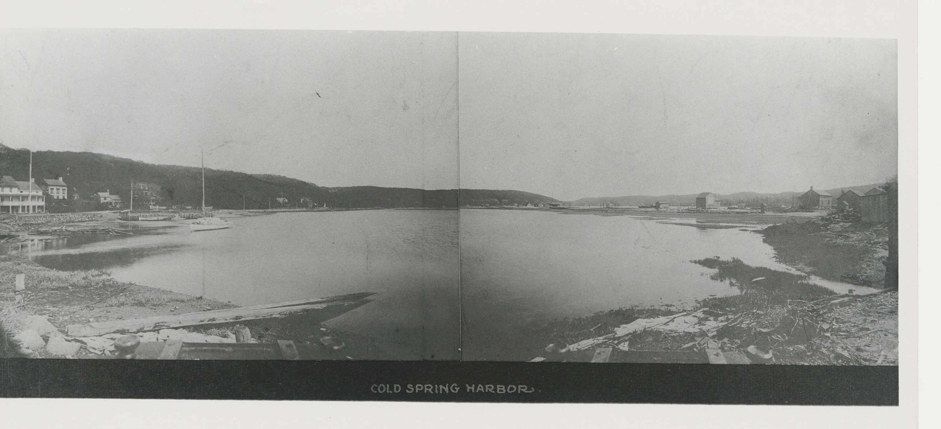
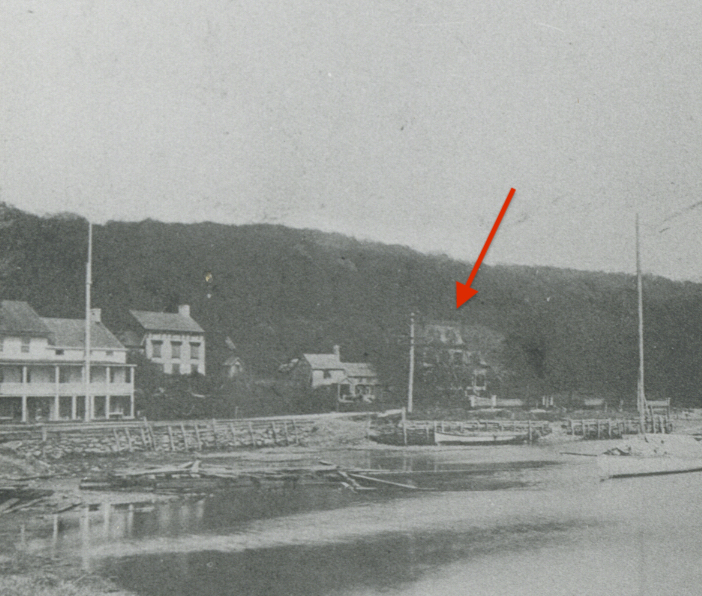
While researching the photograph collection at the Huntington Historical Society on another topic, I found apanoramic photograph of the outer cove of Cold Spring Harbor taken from what is now the driveway to Eagle Dock Community Beach.  Partially hidden behind trees is a glimpse of a mansard roof house along Shore Road.  The supposition that the house was in Cold Spring Harbor appeared to be correct.

A search of deeds on file with the Suffolk County Clerk revealed that William Neale purchased a three-quarter acre lot on the east side of Cold Spring Harbor from Susan Titus in 1872.  Without tracing deeds for the neighboring properties, it was unclear exactly where on the east side of the harbor this land was.  It was thought that it was perhaps the property identified as the Titus estate on an 1873 atlas.  

 Tracing the deeds for this property as well as neighboring properties confirmed that Neale had purchased the “Titus Est.” property.  But where exactly was that house.  Perhaps it was on the property now occupied by a house built in 1941—the only “modern” house along Shore Road (that house was built by Johnston de Forest as a wedding gift for his daughter Priscilla and her husband Doug Williams).  What happened to the house?  It was assumed that the house must have burnt down because there are no mansard roof houses on Shore Road.  Yet no article about a fire or other calamity could be found.

After a month of sleuthing, the answer suddenly became clear, especially after reading the early twentieth century deeds in Riverhead.  The house had not burnt down.  It was still standing at 72 Shore Road.  

72 Shore Road in 2022

William Neale’s widow sold the property in 1886.  Over the next five years, it changed hands five times.  Finally, in 1891, John P. Dole, who lived three doors down on Shore Road, purchased the property.  Dole died in 1902 and the next year his widow sold the property to their son Edward Everett Dole.  He in turn sold the property in 1916 to William A.W. Stewart, whose wife was the daughter of Robert W. de Forest.  Everett Dole continued to live on Shore Road; presumably he moved back to his parents’ house at 48 Shore Road, which he called Tide Crest (his mother died in 1925).

According to a historic structure inventory for the Titus House completed in 1979, for which Priscilla de Forest Williams (Robert de Forest’s granddaughter) is listed as the source, “The house was remodelled by Mrs. W.A.W. Stewart, Jr. about 1920, to more closely resemble a Southern plantation house.”  Mrs. Stewart was Priscilla Williams’ aunt Frances Emily de Forest.

The inventory also cited a survey dated September 9, 1871 made for George Mowbray, who at that time owned 60 acres along Shore Road.  The survey included a sketch of the Titus House showing it to have been “a 3-bay 1 ½ story house with small eaves windows, sidehall entrance, and an interior end chimney on the north.”

 It seems that William Neale remodeled the Titus House in 1876 by adding a mansard roof and that half a century later Mrs. Stewart had it removed.  Mystery solved.  

The research also shed light on the other two nineteenth century houses at this end of Shore Road.  The one and half acre property immediately to the north (at 76 Shore Road) was purchased in 1828 by Eliphalet Rogers from the estate of John Lefferts.  The property stayed in the Rogers family for the next 80 years.  There had been two houses on the property into the twentieth century.   The first house built on the property was southwest of the existing house.  The panoramic photograph of the cove shows it to have been a modest house.  It was demolished some time after 1916.  The surviving house may have been added after Eliphalet Rogers died in 1862–or Eliphalet could have built it.  

The last Rogers family members to live there were Eliphalet’s son Charles and daughter Catharine.  But they didn’t own the house, their brother Henry did.  

Henry Rogers lived in Brooklyn and was well-off, although it is unclear what he did for a living.  In an obituary, Henry is identified as a manufacturer.  Later articles say he was a sea captain.  The 1880 census lists him living on Shore Road in Cold Spring Harbor, and gives his occupation as an architect/house builder.  In 1900, he is identified as a carpenter.  In any event, Henry Rogers seems to have been well off–his estate was valued at $65,650, which is equivalent of $1.8 million today.  His brother and sister, neither of whom ever married, were not so well off.  They were described as indigent and relied on their brother for financial support.

When Henry died in 1906, there was a dispute about his will, which had been drawn up shortly before he died.  The will left everything to his wife, leaving nothing to Charles and Catharine, who had been dependent on Henry’s support.  The will was disallowed.  During the administration of the estate, the property was auctioned off.   Edward Everett Dole, who had grown up down the street and whose summer house was next door in the Titus-Neale House (he also lived in Brooklyn), purchased the property from the estate.  He sold it a few months after Catharine Rogers died in 1916.  I suspect Dole let Charles, who died in 1914, and Catharine live out their lives in the homestead.  In the same deed, Dole also sold the Titus-Neale House to the south to Stewart.

The house to the north of the Rogers’ house was at one time a hotel.  Robert H. Bold, who appears to have immigrated from England in 1834, purchased the southern half of that property in two transactions in 1838.  He was identified on one of the deeds as a merchant.  On the 1850 census, he is identified as a Hotel Keeper.  Bold must have died sometime between 1850 and 1856 because by 1860, his wife Sarah had married a Portuguese immigrant, with whom she had a three-year-old daughter.  The two younger daughters of Robert Bold are listed in the household.  The oldest daughter would have been 18 by this time. 

Sarah Bold’s new husband’s name was given as Joseph Prayer on the 1860 census; Joseph Prairie on the 1870 census; and Joseph Perry on the 1880 census.  No telling how his name was really spelled.  He is identified in the census records as a boatman in 1860 and 1880 and as a watchman in a shipyard in 1870.  The Abrams boatyard was located across the street.

In 1884, the three daughters of Robert Bold sold the property to Elwood Abrams, who operated the shipyard across the street.  One could assume that their mother had probably died shortly before the land was sold.  According to the book Clamtown, written by Leslie Peckham, who lived nearby, Elwood Abrams operated an ice cream, soda, candy and tobacco store as well as a boarding house in the home.  After he died in 1917, his daughter Ella and her husband William Wright continued to run the boarding house.  William White also worked as a painter at his brother-in-law’s shipyard and Ella White was also a dressmaker. 

According to Maggie Norton, who was born in 1910 and grew up on Shore Road (and was the granddaughter of John & Jane Dole), the house was known as “Dirty Dick’s boarding house” and it was run by a widow and her son Raymond, whose erratic behavior the children of the neighborhood found scary—he would “spent the day walking back and forth on the porch tearing up tin cans.”  In the census records, no occupation is ever listed for Raymond, who died at age 42 in 1925.  Raymond’s father also died in 1925, so the boarding house was not operated by a widow.   William White must have stayed out of sight. 

Ella White died in 1930.  She spent the last year or so of her life with her daughter in Glen Cove.  In 1929, her brother Walter Abrams sold the house to Julia Fairchild, who added an addition to the north.

Read Full Post »

Babylon 150

 In the 1870s, the Town of Huntington gained a one-mile road, but lost 114 square miles of land.

 Through numerous land purchases from the indigenous residents in the seventeenth and eighteenth centuries, Huntington stretched from sea to shining sea, or at least from the Long Island Sound to the Atlantic Ocean, including the 114 square miles that is now the Town of Babylon.  Originally, European settlers established homes on the north shore.  The south shore was valued for the abundance of salt hay, which north shore farmers would cut to feed their livestock.  Every fall, the farmers would cross the island to cut, cure and cart the hay from the south shore to their farms.

 Eventually, Huntington South, as the area was known, attracted full time residents.  Three hamlets developed—Babylon, Amityville, and Breslau, now known as Lindenhurst.  As these South Side areas grew, their interests diverted from those on the North Side.  In addition, to attend to Town affairs, such as the annual Town meeting, they would have to travel across the Island.  By the 1850s, the Town meetings were held at Elias Smith’s house in Long Swamp  (on the east side of Beverly Road, north of Jericho Turnpike).  Intended to accommodate South Side residents, it must be admitted the location was closer to the north shore than halfway between the shores.

As early as 1852, there were proposals to split the town in two.  Thirteen residents gave notice that they intended to ask the Suffolk County Board of Supervisors to create a new town of Babylon from the lower half of the Town of Huntington.  The boundary line would run west from the southwest corner of the Town of Smithtown through Melville along Old Country Road. Nothing came of that effort.

Enter Henry Livingston, who on July 7, 1869 published the first edition a new newspaper, the South Side Signal.  Livingston was a booster of the South Side, particularly the village of Babylon.  By his third issue, he was advocating for succession: “The division of the town of Huntington is being talked of by those who object to going to the North Side to attend to town business.  In many respects there would be much to gain by a proper division of the Town, as it is full large for convenience.”

A few months alter, he was more explicit: “Huntington is large enough in territory to make two good-sized towns, while the rapid increase of population on the South Side will allow this half to govern itself. We feel kindly towards the North Side but the village of Huntington cannot much longer make laws for Babylon.” (South Side Signal, February 12, 1870). South Siders also contended that “they pay the largest share of the taxes, while the most lucrative offices are given to the people on the north side.” (The Brooklyn Union, January 16, 1872, page 4).

In addition to the convenience of being able to conduct town business closer to home, those agitating for a new town were incensed by the construction of a new road from Main Street in Huntington village to the harbor.  William A. Conant, Suffolk County’s representative in the Assembly, introduced a bill “for the laying out and opening of a highway in the village of Huntington.” The bill was approved by the legislature in May 1869.  The so-called “road bill” authorized the purchase of land for a street to run from Main Street opposite the center line of South Street (now New York Avenue, NYS Route 110) northward to the east side of Huntington Harbor, a distance of one mile.  

The bill authorized the County on behalf of the Town to levy a tax of $4,000 to cover the expense of constructing the road.  The cost of acquiring the land, which was to be determined by independent appraisers, would be raised by another tax.  To put that sum in perspective, in April 1871, the Town raised $200 for roads and bridges throughout the town.  The amount collected for “Contingencies,” i.e., general expenses, was $ $4,500.  In other words, construction of the road would almost equal all other Town expenses for the year (other than care of the poor, which was the largest annual expense at $7,000).  

The tax was not well received.  Several residents petitioned the Town Clerk to call a Special Town Meeting to consider “what measure, if any, shall be pursued by the taxpayers of this Town, to resist, as we consider the unjust expenditures intended to be levied and collected upon the assessed property of the whole Town” for the building of the new road.

 The Special Meeting was held at Long Swamp on June 15, 1870.  Opponents of the new road contended that the road bill was pushed by Assemblyman Conant “for his own personal benefit, and that of a few of his friends, in violation of the rights of the people, and contrary to the interests and wishes of his constituents.”  Furthermore, they contended that the road “is intended to benefit the few at the expense of the many; it is unnecessary and uncalled for; its construction will impose upon the Town a heavy taxation, for which no adequate benefit will be received.”

  “We condemn the whole scheme as selfish, oppressive, unequal, unjust and insulting to our people.”

 The vote in favor of the resolution against the road was 403 to 0.  Soon after the Special Town Meeting, an injunction was issued restraining the Commissioners with proceeding on the road project.  However, since the road was authorized by the State, only the State could abandon the project.  By July the road was complete from Mill Lane to the harbor and by Halloween it was completed from Main Street to the harbor.  Litigation continued even after the road was completed. But all proceedings were finally dismissed in April 1871.

In his annotation to the Town Records, Charles R. Street notes that “There was much public excitement over the matter and considerable of opposition to the road, resulting in a protracted lawsuit, but the Commissioners performed the duty imposed on them by law, and all their proceedings were sustained.  The utility of the road is now [in 1889] universally conceded.”

The energy directed at stopping the road was now directed to splitting the town.  In addition to the burden of paying the tax assessment to construct the road, arguments were made about the lack of representation for those who could not afford the time to travel long distances to town meetings.  Democracy required smaller towns, both in terms of geographic area and population.  The argument was not limited to the town of Huntington.  The same considerations applied to Brookhaven, Southampton and other large towns in both Queens and Suffolk Counties.  Yet only Huntington was divided.

 By September 1871, it seemed leaders on both the North Side and the South Side agreed that the town was too large to serve the interests of “convenience, unity or harmony.”  In December 1871, the Elias Smith House, which the Town had purchased in 1868 for use as the Poor House as well as a venue for Town meetings, burned down. (Coincidentally, the Poor House was offered for sale for $4,000—the same amount the State Legislature directed the County Board of Supervisors to tax for construction of New York Avenue.  The sale only realized a price of $2,600.)  With no centralized place to meet, it was thought the time to proceed with a division of the town was at hand.

On January 9, 1872, less than a month after the fire at the Poor House, residents of the first election district met at Euterpean Hall in Huntington village and adopted the following resolution:

Whereas A diversity of interests has been created within the last few years by the rapid growth and increase of the villages on the North and South Sides of the Town of Huntington, and 

Whereas, the Town House, where the people have heretofore held their Town Meetings has recently been destroyed by fire, and no appropriate or commodious building now exists in the central part of the Town, where Town Meetings can conveniently be held and 

Whereas, the People of the South side of the Town have, through their local Press and otherwise, exhibited a desire to have the Town divided and to erect a new Town, [it is] now therefore 

Resolved, That it is the sense of this meeting, that a fair and equitable division of the Town of Huntington would result in benefit to each section, and that we are in favor of such division. 

Resolved, That a written request be immediately executed and delivered to the Town Clerk for a Special Town Meeting to be held at or near the Town Farm at Long Swam at an early day as practicable, to take the sense of the people of the whole Town, on the Question of a division of the Town, and if favorable to such division, to decide upon a dividing boundary, and to take such further action as will effect the object. 

Resolved, That we deem an application to the Legislature for the passage of a suitable Act to be the best, most expeditious and most advisable method of procuring such division.

The residents also appointed a committee of three (Town Supervisor J. Amherst Woodhull, Henry C. Platt and former State Assemblyman William A. Conant) to confer with committees from the Town’s other four election districts.  The residents of the Babylon and Amityville election districts adopted a similar resolution.  In the Central or Long Swamp District, the residents expressed an interest in dividing the Town into three new Towns.  They felt that as currently constituted the residents of the middle of the Town could hold the more populous North and South Sides in check by aligning with whichever one was to their advantage on  a particular issue.  Being part of a Town with one or the other would leave them helplessly outnumbered.  The proposed central Town would include the area between the Main Line of the Rail Road and the northern branch line (i.e., the Huntington line).  

With a speed that would astonish the modern-day residents of Long Island, the wheels of government now turned quickly.  Representatives from each district met in Deer Park on January 17 and adopted resolutions calling for a town-wide vote on January 27 to decide whether to divide the Town into two parts, three parts, or leave it as is.

As we know, the vote favored the two Town proposition as follows:

DistrictTwo TownsThree TownsNo Division
Huntington15623983
Northport303195
Babylon21500
Amityville23004
TOTALS631242282

The central district chose not to hold a vote and instead planned to attack the division separately.

The voters also elected two representatives from each district to determine the dividing line between the Towns.  The Division Committee met the Monday after the election in Babylon and drew the dividing line a half mile north of the Melville Church, on Old Country Road, to run directly west to east, the same line proposed in 1852. Melville residents objected, preferring to stay in the Town of Huntington.  The line was then moved south about three miles to a line one mile north of the Rail Road’s main line. 

The legislation creating the Town of Babylon was passed by the State legislature on March 13, 1872.  An election for the new Babylon Town Board was held on April 2 and the newly elected representatives met that same day.

Read Full Post »