What’s in a name? When trying to promote development of an area, its name is important, especially if the name is not appealing. Think Mosquito Cove (now Glen Cove) or Drowned Meadow (now Port Jefferson). In Huntington, what had been known for over a century as Gallows Hill is now Fort Hill.
The story begins during the American Revolution when Huntington was occupied by the British. To guard their position in Huntington, the British built a fort at the eastern approach to the Town Common. The fort stood at the intersection of today’s East Main Street and Maple Hill Road, at the point where East Main Street descends to the Park Avenue valley. Traces of the fort could still be seen as late as a century after the war but are now lost.
At the end of the war, the area near the fort was the site of a hanging. Over the years, the identities of the men hanged and even which side they were on became confused. In one telling, the two men were British soldiers who rode to their execution on their coffins. The other version claims the men were American spies.
In 1975, Huntington’s Bicentennial Committee went with the American spies version of the story and erected a historic marker on Huntington Bay Road. The marker text: “Near this spot, two American Martyrs were hanged by the British during the Revolution.” Why that particular spot was chosen to place the marker is not known.
Recent research by David M. Griffin, who has written two books about the American Revolution on Long Island,* confirms that the Bicentennial Committee chose the wrong version. The two condemned men were Isaac Algar and Nathaniel Parker, who fought for the British. In August 1783, they were convicted of robbing and beating Platt Carll, who operated an inn on the north side of Jericho Turnpike between Manor and Warner Roads. The convicted men were hanged on September 10, 1783 (the executioner was Provost Marshal William Cunningham, who was also present at Nathan Hale’s hanging seven years earlier). Two and a half months later, the British evacuated from New York City.
The 1837 Coastal Survey Map
For generations, the hill east of Park Avenue and north of East Main Street was known as Gallows Hill. It was so labeled on the 1837 Coastal Survey map. Nineteenth century deeds described Maple Hill Road as the road to Gallows Hill. The area was sparsely settled, so no one much minded the name. But by the turn of the twentieth century, when more and more houses were built, it was decided a new name should be found. Reference to the fort, even though it was a British fort, was preferable to a reference to the site of an execution. Hence Gallows Hill became Fort Hill.
To correct the record on September 23, 2024, a new historical marker was placed at the intersection of Maple Hill and Fort Hill Roads.
*Lost British Forts of Long Island (The History Press 2017) and Chronicles of the British Occupation of Long Island (The History Press 2023)
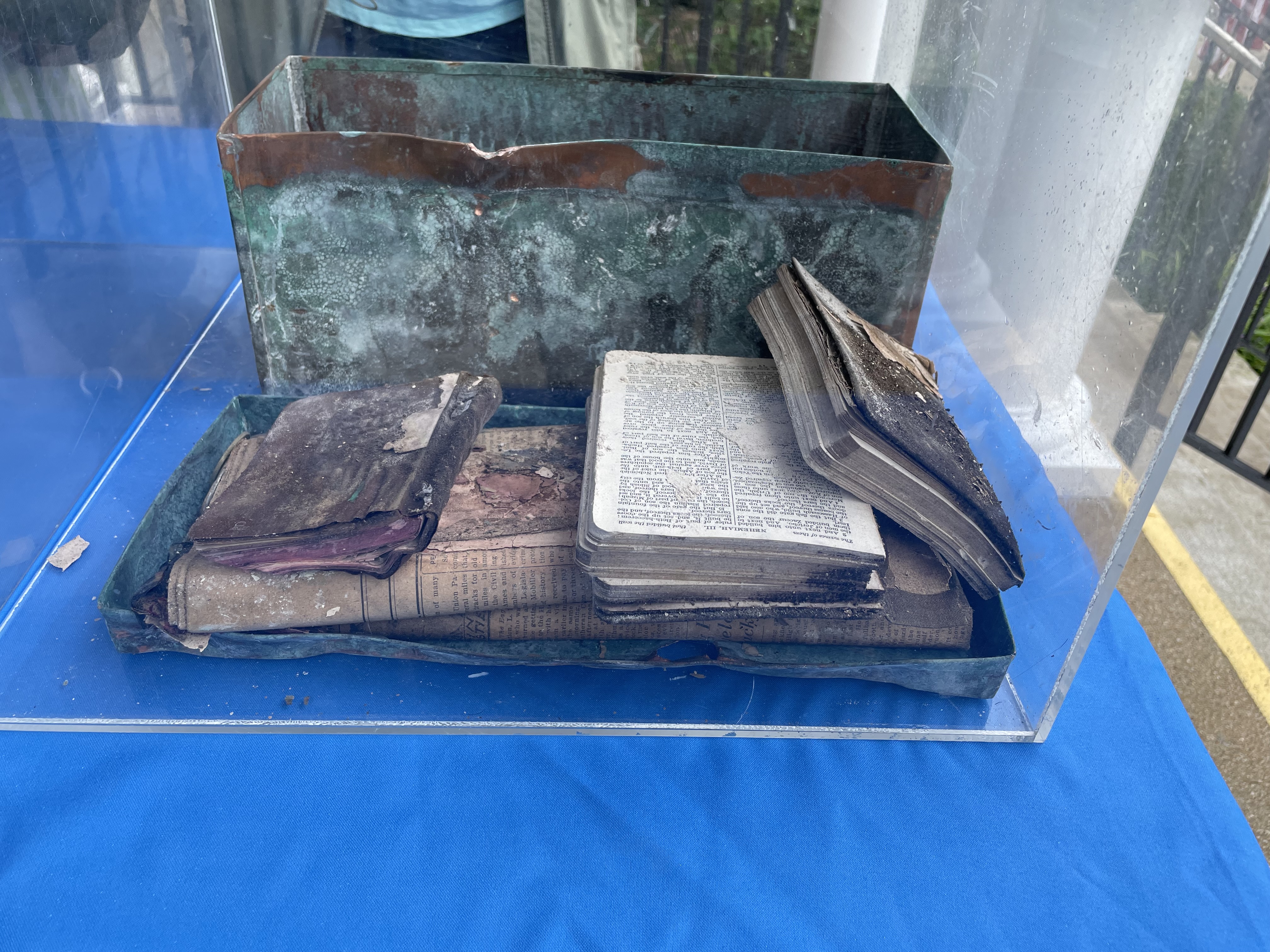
Corner stones at the Laurel Avenue school in Northport and at the Broadway School in Greenlawn were chopped out to remove time capsules from 1924.
The contents of the 1924 time capsule at the Greenlawn School
That’s because 1924 was a year of growth and change. That year saw the greatest number of new buildings in Long Island history up to that point. The decade saw tremendous growth in Huntington. The population of the Town increased by 84% from 1920 to 1930.
Among other things that happened in 1924, the village of Huntington Bay was incorporated and the post office started delivering mail directly to people’s homes in Huntington village!
Throughout the 1920s, farms and estates were being subdivided. The Cartledge Estate became Bay Hills (1924); the August Heckscher estate became Wincoma (1925); The Fleet Farm became Huntington Beach (1926) and Knollwood (1924); and the old Kissam farm in Greenlawn became Cedarcroft (1926).
In Greenlawn, land south of the railroad tracks and east of Broadway (Gates & Grafton Streets) was subdivided in 1921 as Maple Park. Two years later, the property of Edward Smith was subdivided. The land on the west side of Broadway was subdivided into 45 lots, including a large lot for a new school. A year later Smith’s property across the street was subdivided into 93 lots (Fenwick & Lawrence Streets). The rest of his farm later became the high school.
This increased development required increasing the number of schools. During the 1920s, new schools were built in Northport, Halesite, Huntington, Huntington Station, Cold Spring Harbor, Melville and Greenlawn. The South Huntington and West Hills School district merged to better address the population boom.
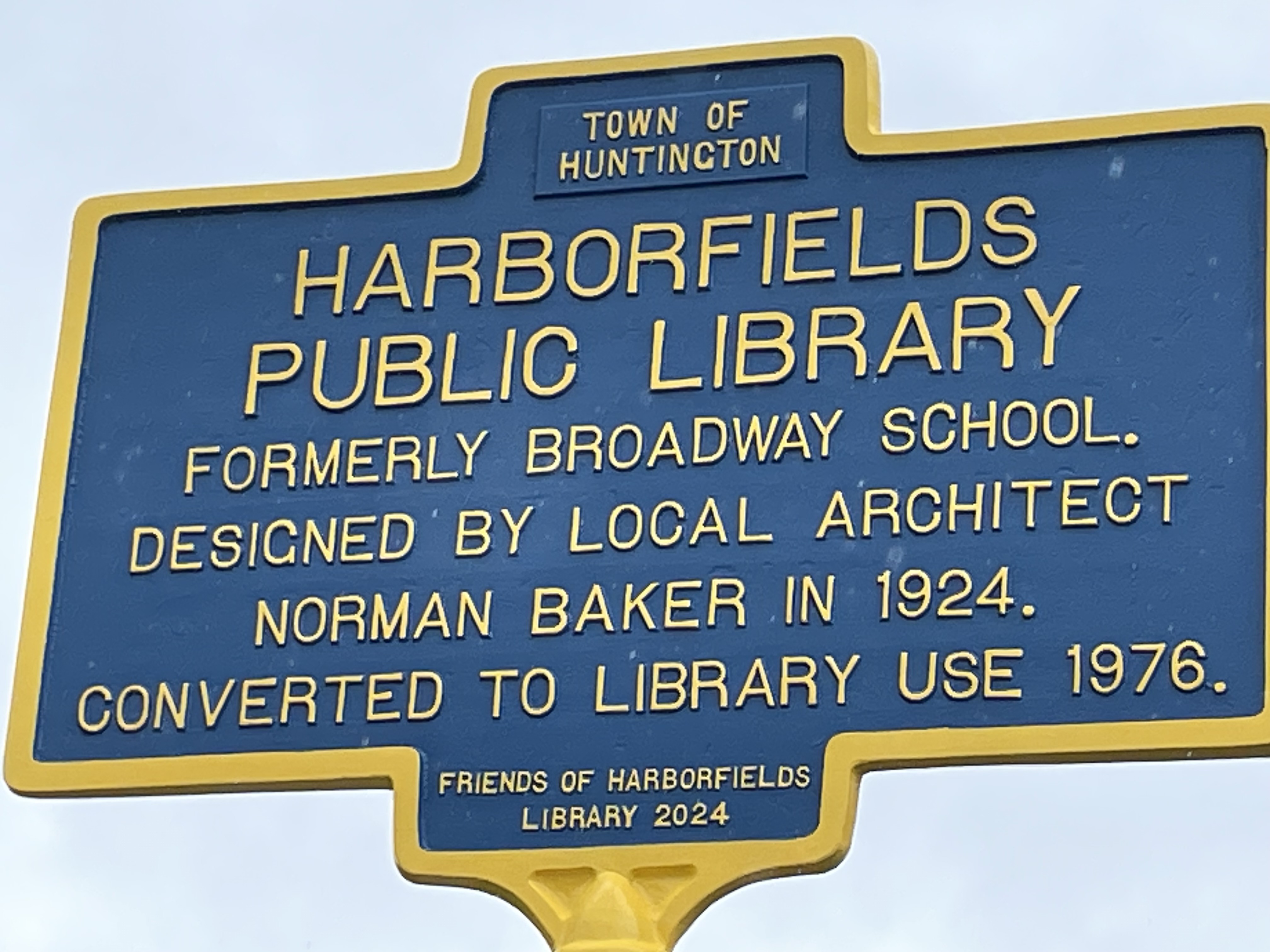
Many of those schools have survived and been repurposed. Adoptive re-use is critical to the survival of historic buildings. The Greenlawn, later Broadway School, may have outlived its usefulness as a school, but it did not outlive its usefulness to the community. It has found its second act as the home of the Harborfields Library. Today, the Greenlawn community celebrated not only the centennial of the Greenlawn School, but also the transformation of the building into a new library half a century ago.
Other second acts include the Northport High School on Laurel Avenue which became a school administrative center; the Main Street School in Cold Spring Harbor is now the DNA Learning Center; the Melville School is now the Melville branch of the Half Hollow Hills Library; Lincoln School in Huntington Station is now the Lincoln Farm apartments; and the Nathan Hale School in Halesite is now co-op apartments.
Harborfields Library, formerly the Broadway School, formerly the Greenlawn School
In just over two years, the United States will celebrate the 250th anniversary of its independence. It may seem that a country settled in part by people calling themselves Separatists was destined to be independent. While the roots of independence can be found in the country’s earliest English settlement, the actual reality of independence was slow to develop. Certainly in 1774, Americans considered themselves to be very much a part of the British empire.
A central question that gave rise to the Declaration of Independence in July 1776 was whether Parliament had the authority to tax the colonies. The question became more urgent in the aftermath of the Seven Years War (1756-63), also known as the French and Indian War, as parliament sought to raise revenue to help pay war debts.
The first effort, the Stamp Act of 1765, was short lived being repealed in 1766. It was followed by the Townsend Act of 1767, which imposed a tax on British china, glass, lead, paint, paper and tea imported to the colonies. The colonists boycotted these goods and eventually the taxes were repealed with the exception of the tax on tea. Colonist, who were among the biggest drinkers of tea in the world, often consumed smuggled tea, but purchased taxed tea as well.
The Tea Act of 1773 was passed to help the struggling Britain’s East India Company. The company would no longer be required to sell its tea at auction in England. It could now ship tea directly to consignees in the American colonies, thereby saving the customs duties when the tea was conveyed through English markets. The three pence a pound tax upon import to the colonies was continued. Taxed tea sold for 2 shillings a pound (including the 15% tax) and would now be competitively priced in relation to smuggled tea, even a bit less expensive than smuggled tea.
However, for both Britain and the colonies, it wasn’t the money. It was the principle. Parliament wanted to assert its authority to impose taxes on is colonial subjects. The Americans were just as adamant that they should not be taxed by a body in which they had no representatives.
This refusal to pay the tax led to the Boston Tea Party on December 16, 1773. Rather than accept delivery of the tea and pay the tax, Bostonians dumped the tea in the harbor. In response to the Bostonians’ defiance, Parliament passed what came to be known in America as the Intolerable Acts, which among other things, shut down the Port of Boston until the damaged tea was paid for.
Samuel Adams, a leader of the Sons of Liberty in Boston, called for a continental congress to develop a unified colonial response. Others called for a boycott of British goods. News of the Boston Port Act reached Manhattan on May 11, 1774; it probably reached Huntington a week or two later.
While support for Boston varied throughout the colonies, Huntingtonians were unambiguous in their support for their neighbors to the north. Huntington declared “that our brethren of Boston are now suffering in the common cause of British America.” That common cause was to fight taxation without representation.
On June 21, 1774, Huntington adopted its Declaration of Rights asserting that “every freemans (sic) property is absolutely his own, and no man has a right to take it from him without his consent, expressed by himself or his representatives.” Therefore, without representation in Parliament, the colonies could not be taxed by that body.
This view was long held by Huntington’s residents. As early as 1670, six years after the Duke of York asserted control of Long Island, the townspeople refused to comply with an order to help repair the fort in Manhattan in part because “wee conceve wee are Deprived of the liberties of english men.”[1] The English had promised a Colonial Assembly with delegates elected by the people. Since the Assembly no longer met by 1670, the tax imposed by the Royal Governor amounted to taxation without presentation. Likewise, in July 1691, the Town adopted an oath that no tax shall be imposed except by act and consent of the governor, council and “Representatives of ye people.”[2]
The views expressed in Huntington’s Declaration of Rights were also consistent with the resolutions eventually adopted by the First Continental Congress which met in Philadelphia from September 5 through October 26, 1774. The first resolution adopted by the Congress was “That the inhabitants of the English Colonies in North America, by the immutable laws of nature, the principles of the English Constitution, and the several Charters or Compacts, have the following Rights: . . . That they are entitled to life, liberty, and property, and they have never ceded to any sovereign power whatever a right to dispose of either without their consent.”
Other towns throughout New England, including on Long Island, adopted similar resolutions. A week before Huntingtonians met, residents of South Haven (i.e., the southern section of Brookhaven Town) adopted resolutions declaring the blocking of the port of Boston to be unconstitutional and that the colonies should adhere to a non-importation agreement. Likewise, on June 17 East Hampton pledged to support their fellow colonists and to participate in a non-importation agreement. The resolutions adopted by these Towns did not spell out citizen’s rights as completely as Huntington did. On August 9, Smithtown adopted the Huntington resolutions. In November, the Committees of Correspondence of Suffolk County voted their full approval of the Continental Congress.[3]
The following May, two weeks after the Battles of Lexington & Concord, Huntingtonians voted “that there should be eighty men chosen to Exercise and be ready to March.”[4] The tenor of the conversation had changed.
Although in his Centennial Address delivered on July 4, 1876, the Honorable Henry C. Platt deemed the Declaration of Rights to be “Huntington’s DECLARATION OF INDEPENDENCE,”[5] this is clearly a misreading of the document. There is no mention of independence, just an assertion of rights as citizens of the British Empire. The full text of the Declaration of Rights appears below. Although the author is unknown, it is thought that it was written by John Sloss Hobart, Lord of the Manor of Eaton, because he had legal training. He served as a representative to the New York Provincial Congress and after the war was a judge and U.S. Senator.
(1774, June 21,)
1st That every freemans (sic) property is absolutely his own, and no man has a right to take it from him without his consent, expressed by himself or his representatives.
2nd That therefore all taxes and duties imposed on His Majesties subjects in the American colonies by the authority of Parliament are wholly unconstitutional and a plain violation of the most essential rights of British subjects.
3rd That the act of Parliament lately passed for shutting up the Port of Boston, or any other means or device under color of law, to compel them or any other of His Majestys (sic) American subjects to submit to Parliamentary taxation are subversive of their just and constitutional liberty.
4th That we are of opinion that our brethren of Boston are now suffering in the common cause of British America.
5th That therefore it is the indispensable duty of all colonies to unite in some effectual measures to the repeal of said act and every other act of Parliament whereby they are taxed for raising a revenue.
6th That it is the opinion of this meeting that the most effectual means for obtaining a speedy repeal of said acts will be to break off all commercial intercourse with Great Britain, Ireland and the English West India colonies.
7th And we hereby declare ourselves ready to enter into these or such other measures as shall be agreed upon by a general congress of all the colonies: and we recommend to the general congress to take such measures as shall be most effectatl (sic) to prevent such goods as are at present in America from being raised to an extravagant price.
And lastly we appoint Colonel Platt Conkling, John Sloss Hobart Esq. and Thomas Wickes a committee for this town, to act in conjunction with the committee of the other town in the county, as a general committee for the county, to correspond with the committee of New York.
[5] “Old Times in Huntington, An Historical Address by Hon. Henry C. Platt, Delivered at the Centennial Celebration at Huntington, Suffolk County NY on the 4th day of July, 1876, page 19
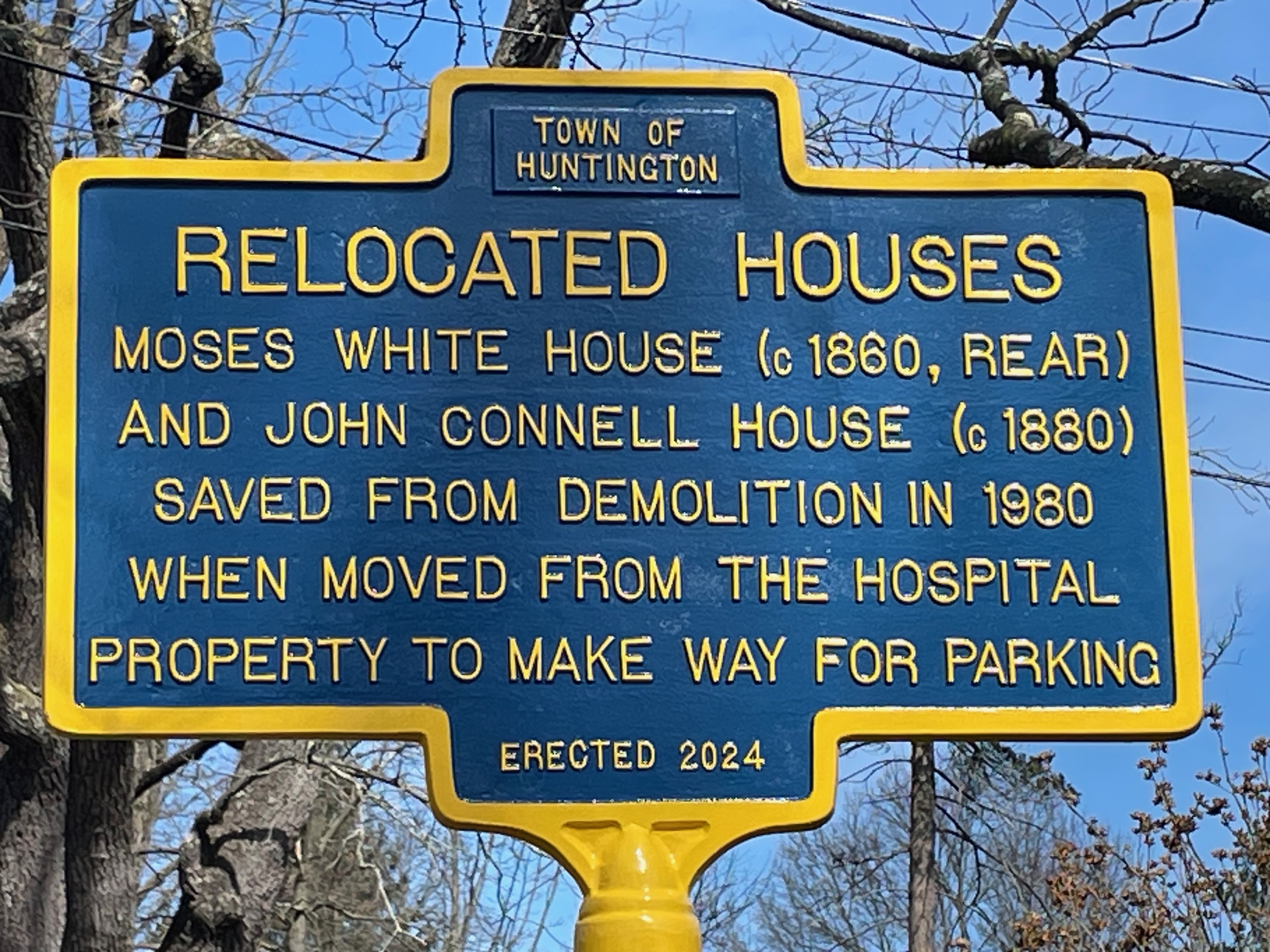
To historic preservationists, context is important. The setting of a historic building is an integral part of the building’s history. That is why moving historic buildings is frowned upon. But relocation is better than demolition. In the late twentieth century, three nineteenth century houses were moved from the Huntington Hospital campus to locations up Park Avenue. While they may have lost their context, they survive.
The story begins with parking—or rather the lack of parking. Huntington Hospital was in desperate need of more parking. To help alleviate the problem, the hospital purchased the property at 44 Maple Hill Road. On that property was a century old house, built around 1880, and the one-time home of John Connell, whose son Michael opened the namesake funeral home in Huntington Station in 1923. In September 1979, the hospital applied for a demolition permit to clear the land for parking. Town Historian Rufus Langhans inspected the house and found it to be structurally sound and that it still retained many of its original architectural features. He persuaded the hospital to give him time to find someone who would be interested in moving the house.
Press coverage of the availability of a free house attracted about 20 seriously interested prospects. Unfortunately, mortgage interest rates rose from 9 ½% to 12 ½% rendering the project unaffordable for the young couples that had expressed an interest. Langhans then suggested the Town of Huntington take on the cost of moving the house and then offer it for sale at its new location. He found a vacant one third acre plot on Park Avenue. He estimated the land could be purchased and the house moved and renovated for $51,000. A realtor told him similar renovated historic houses in the area sold for $70-75,000. The Town might even make a small profit on the project. Fortuitously, the State had in 1976 passed an act “authorizing the town board of Huntington, Suffolk County, to designate and sell historic edifices.” Langhans suggested using the revolving fund set up under this act to effectuate the house moving.
The hospital wanted the house moved by October 3, so they could pave their new parking lot before cold weather forced the closure of the asphalt plant. That deadline came and went with the house still on the property. In late January 1980, Langhans reported to Town Supervisor Kenneth Butterfield that he had found a serious buyer who would have the money to buy the house on March 1 when she closed on the sale of her current house. She agreed to bear the expense of moving the house.
At the same time that Langhans was working to save this house, he was also advocating the creation of the Old Huntington Green Historic District, which would protect the dozens of historic houses in Huntington’s “Old Town Spotte,” which ran along Park Avenue. The Town Board created the new historic district in November 1980.
Things were falling into place. The hospital owned another historic house at the corner of Park Avenue and Maple Hill Road. That house, which dated to about 1860, was also slated to be demolished to make room for parking. Gay Wagner, an independent preservation consultant who worked with Langhans on this project and in completing a survey of historic structures throughout the town, suggested that both houses be moved at the same time to save on the not inconsiderable expense of raising electrical and telephone wires along the route the houses would take up Park Avenue.
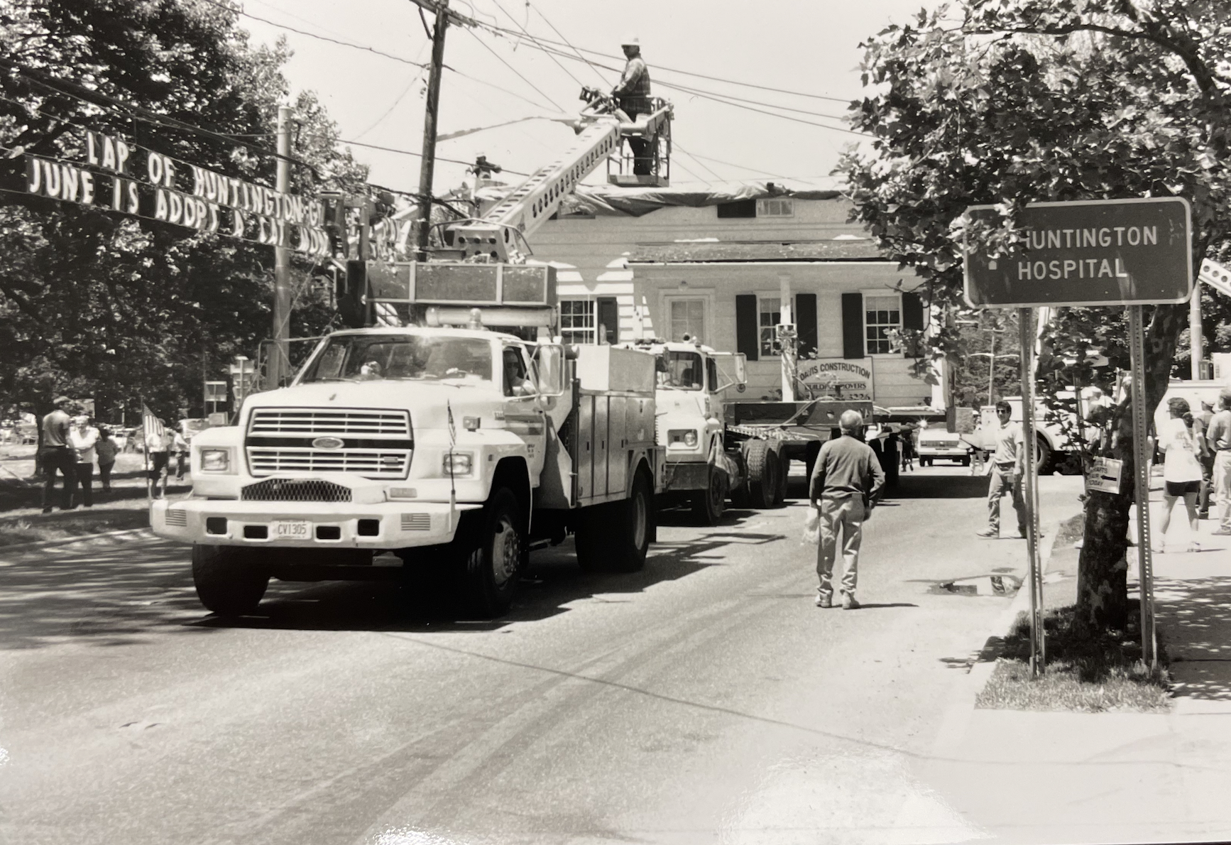
A recent 5-lot subdivision of a 1.84-acre property running from Park Avenue through to Harriett Lane, between Linda Lane and Leslie Place, was chosen as the site for the two houses. The lot on Park Avenue would receive the Connell House from 44 Maple Hill Road and the flag lot behind it would receive the Moses White House from 238 Park Avenue. The Town Board unanimously approved the purchase of the rear lot and authorized the move by resolution adopted on March 25, 1980. Two days later, the houses were moved one and a half miles to their new locations.
Langhans thanked no less than 39 Town officials, community leaders, vendors, lawyers and others for their support and assistance in moving the two houses. But much of the credit must go to Wagner and Langhans himself. To convince not only the hospital administration, but also the members of the Town Board that the houses were worth saving and to agree to the logistical complications of the one-and-a-half mile move and in less than six months was an astonishing feat.
The John Connell House (front) and Moses White House moving up Park Avenue to their new locations.
While the John Connell House was being renovated, the Moses White House sat vacant behind it for several months. Then in December 1980, the Town Board authorized the sale of the Moses White House at auction to be held on February 18. Langhans held an open house for prospective buyers on January 16. The house was moved without its front porch or kitchen, which would have to be rebuilt. Also missing was electricity, insulation, plumbing, heat, water and a septic system. The house was also in need of carpentry, masonry, roofing and flooring repairs. Langhans prepared a brochure to promote the auction. He estimated rebuilding the porch would cost $5,637. Interior renovations and repairs, including a new kitchen, were estimated to cost $19,652. Bidding for the house would start at $50,000 to cover the cost of the move. All of which adds up to a bit more than the estimated appraisal of $75,000 for a fully renovated house that Langhans had received before the house was moved.
On the appointed day, Langhans was ready for the auction. True to his character, Langhans said he would light a candle at the auction. “In colonial times, the bidding would end when the candle flickered out and the person who last bid would have the property,” he was quoted as saying. “In todays’ world the ‘lit’ candle will only represent a dying custom since we will allow the bidding to continue as long as necessary.” Langhans also planned to present the winning bidder with “turf and twig,” a nod to an ancient custom when transferring real property.
Leading up to the auction, Langhans had received dozens on inquiries. Interest seemed to be running high. When he lit his candle to start the auction, about a dozen potential bidders were on hand. The Town’s acting Comptroller John Zanfino asked for bids, starting at $50,000. Silence. He asked again; no response. He asked a third time. Still no bids. Langhans couldn’t believe it. He blamed high interest rates.
The house sat vacant and un-repaired. In June 1982—more than two years since the move—the Town Attorney suggested that the house might be easier to sell if it was renovated by the Town. Nothing came of the suggestion as weeds grew to four feet high and birds nested in the cavities created where the porch had been removed.
One day in late 1982, Langhans walked down the block, as was his custom, to get a cup of coffee at Soviero’s Luncheonette (now Mundays). He saw a sign taped to the cash register. Fred Soviero (son of the luncheonette’s owner) and his wife Ronnie had posted the sign saying they were looking for a home for their young family. Langhans told Joe Soviero that he had a nice place nearby that was available. He gave them a skeleton key to the front door and invited them to check it out.
Fred and Joe saw lots of possibilities. When they came back with Ronnie later that same day, she cried thinking this was to be their new home. Tar paper flapped in the wind where the kitchen wing had been. There were no steps to the front door for her to climb to inspect the interior, just a wooden milk crate that was three feet short of the threshold. “It was not what I was expecting for my first house,” she recently said. Somehow, she was convinced to buy the house for $50,000.
In November 1982, the Town Board authorized a sale to Fred & Ronnie Soviero. It took about 18 months before the house was habitable. They hired professionals to install a septic system, a water line and electricity. But much of the work was done by Joe, who was a carpenter, and Fred. For his 30th birthday in 1984, Ronnie invited about 80 friends and relatives over to a surprise birthday party that was really a work party. The guests spent the day working inside and out, pulling down wallpaper, scraping paint, and other tasks needed to make the place habitable. Fred built the kitchen cabinets himself and their kitchen table was an unused booth from the luncheonette until they built an addition for an expanded kitchen and family room in 2000.
By the end of the decade, the Hospital was again looking to create even more space for parking. But this time things were different. In 1988, the hospital had acquired two more houses on Park Avenue. One was a 1920s bungalow. The other was the Adams House, which was dated to about 1830 (however, an 1850 deed seems to indicate that there was no house on the property at that time). Job Adams acquired the property in 1865. Job and his brother James were immigrants from England who worked as “practical gardeners.” Job was also sexton at St. John’s church for a number of years.
In the years since the Moses White and John Connell Houses were moved, the locally designated Old Huntington Green Historic District had been created, as noted above. And several properties, including the Adams House, had been listed on the National Register of Historic Places. Those developments seemed to have changed the neighborhood’s reaction to the hospital’s plans. The hospital met with the Town’s Historic Preservation Commission in August 1989. The hospital proposed demolishing the two houses. The Preservation Commission suggested a compromise: the 1920s bungalow could be demolished for parking, but the Adams House should remain with a 25’ deep backyard. The rest of the Adams House property could be used for parking.
The proposed compromise didn’t hold. Two-and-a-half years later, the hospital proposed moving the Adams House to the grounds of the Dr. Daniel Whitehead Kissam property, which was owned by the Huntington Historical Society. The house would serve as a caretaker’s cottage and provide a needed onsite presence to keep an eye on the historic museum property. The hospital would set aside $140,000 for the move, renovations, and initial maintenance.
The application to the Town to move the building was filed in September 1982. Neighbors were not happy. They formed a “Committee for the Preservation of #244 Park Ave.” The neighbors argued that the net gain of parking spaces by removing the house was only twenty spots. They were also concerned about how the house would fare during the move, especially the stone and cement rear wing, which a previous owner found himself repairing repeatedly. They lamented “the loss of a centerpiece of [the neighborhood’s] historic character and the resultant decline in property values.” The Preservation Commission also opposed the move as did the Society for the Preservation of Long Island Antiquities (now Preservation Long Island), and the Scudder Association. Neighbors suggested that if the hospital wished to be relieved of the burden of maintaining the Adams House, they could donate it to the Historical Society at its original location. The Society would then receive much needed income without compromising a centerpiece of the historic district.
The hospital argued that after the move, the Adams House would still remain within the historic district and that its new setting would be more appropriate than being surrounded by parking lots on three sides. The neighbors countered that the proposed site next to a small stream was too wet. They held a candlelight vigil two weeks before the Town Board hearing on the matter.
The National Parks Service weighed in because the building was listed on the National Register. The Parks Services noted that “properties listed in the National Register should be moved only when there is no feasible alternative for preservation.” After “strongly” urging the hospital and Town officials to consider alternatives, the Parks Services preliminary approved the move in September 1993. The Village Green Civic Association and the Historic Preservation Commission sued. But in January 1994, the court ruled in favor of the hospital and the Town Board. The house was moved in May 1994 to its current site on North Woodhull Street, where it was restored.
The Adams House on the move.
Langhans, who was such a key player in the earlier move, was more or less absent from the Adams House saga, perhaps because he was battling cancer. He died in November 1994, just six months after the Adams House was moved.
Dating a house can be difficult. Take, for example, the red house at 75 Main Street in Cold Spring Harbor. A sign out front proudly identifies it as “1790 House.” In the 1960s, the building was home to a clothing store called 1790 House; and in the 1980s one could shop at 1790 House Antiques.
Since at least 1953, it has been claimed that the house was built circa 1790. A list of “Old Houses” prepared that year for the Town of Huntington tercentenary, in addition to dating the house to the late eighteenth century, also claims it was the “First place in America where Japanese tea was served.” The audacity of that claim should be enough to foster doubt on the veracity of the claimed construction date.
A State Historic Preservation Office Building-Structure Inventory Form prepared in 1979 dates the building back even further to around 1720. The form states, “This house is believed to be an early house of the Conklin family, early settlers in the valley.” The form cites a 1960 publication written by local Cold Spring Harbor historians, Harriet G. Valentine, Andrus T. Valentine, and Estelle V. Newman. That account doesn’t give a construction date; instead, it says “This house still retains its pre-revolutionary character.”
75 Main Street in 2024
The Conklin family did have extensive land holdings in Cold Spring Harbor. Richard Conklin (1726-1787) was born in Smithtown. In 1750, he married Rebecca Titus of Cold Spring Harbor. Their son, Richard (1757-1818) was born in Cold Spring Harbor. So, it seems the family had lived in Cold Spring Harbor since the middle of the eighteenth century. However, no deeds transferring land to Richard Conklin, Sr. have been found.
Richard Conklin, Jr. (1757-1818) fought in the American Revolution. After the Battle of Long Island in August 1776, he fled to New England. At one point, he was held as a prisoner on a ship in New York Harbor. He escaped and made his way back to his home in Cold Spring Harbor. His return was reported to the British, who “attacked the house, firing through the barred door, where he stood until the rest of the family had escaped to a neighbor’s. He then retreated through a swamp and the woods to the shore where his vessel lay.” (Mather’s Refugees of 1776 from Long Island, page 306). That description of escaping through a swamp is consistent with his house being located at 75 Main Street because the area to the north along today’s Spring Street could be described as swampy.
In 1782, Richard, Jr. married Mary Bernard from North Carolina. After the war, he returned to Cold Spring Harbor where he was a seaman. In the nineteenth century, his home, known as Evergreen House, was on Harbor Road, near Portland Place, approximately where the old motel is now located. He may have built this house around the time he married because when it burned down in 1899, it was described as being a hundred years old. It could be possible then that 75 Main Street was the Conklin homestead prior to the Evergreen House.
As for determining when that house was built, there are several ways to date a building in the absence of building permits, which were not required in Huntington until 1934. One can consider the style of the building, construction methods, materials, and documentary sources. Nineteenth century Long Islanders tending to be somewhat conservative when it came to architecture, being slow to adopt new styles. As a result, older forms continued here well after other regions had moved on.
The house at 75 Main Street incorporates some features of the Greek Revival style that became popular starting around 1820. The house features a simple cornice with returns, garrison windows and narrow sidelights around the entry. On the other hand, hand hewn beams visible in the west section of the house and the house’s narrow, tapered newel post point to an eighteenth-century construction date.
However, unused mortises on the hand-hewn beams indicate that they may have been recycled from an earlier building (other beams are milled) and the narrow newel post on the stairs is consist with a 1790 construction date as well as a later date. The foundation is rubble stone topped with several courses of brick. Use of bricks in a foundation points to a nineteenth century construction date.
Rubble foundation topped with brickNarrow, tapered newell post Hand-hewn beams with unused mortises
Another piece of evidence is the deed for the property. Richard M. Conklin, son of Richard, Jr., sold the 70’ x 100’ lot on which the house sits to Israel Valentine, a carpenter from Oyster Bay, on Leap Day 1836. This seems to have been only the second sale of land on Main Street—two months earlier Conklin sold the lot to the west to Abraham Walters. Most telling is a restriction in the Valentine deed that “any house to be erected shall range in front with those lately erected by Richard M. Conklin and Abraham Walters and no building erected shall be nearer to the said highway.” If the house already existed, there would be no reason to include this restriction. In addition, according to the deed, the property consisted of two 35’ lots. If there was a building on the property, why create a lot line running through it?
While one hesitates to contradict a widely accepted 70-year-old claim, it seems possible that the house was built by Israel Valentine in 1836, rather than by the Conklin family in the eighteenth century.
While the age of this building may be uncertain, its history after 1840 is clearer. That was the year that Samuel M. Sutton acquired the property from Israel Valentine. The 1850 census lists Sutton’s occupation as Stage Proprietor. His household included his wife and daughter as well as a physician, a tailor (and his wife and son), a laborer, and an Irish immigrant whose occupation was not given. The number of non-relatives would be consistent with running a hotel. According to an account from 1903, in 1841 Sutton kept the only hotel in Cold Spring Harbor.
Local Temperance Society members were unhappy that Sutton served liquor in his hotel. In 1841, they organized a march from Huntington village to Sutton’s hotel to destroy his liquor. It appeared Sutton saw the error of his ways. The Temperance Society offered to buy his stock of liquor and he agreed to sell. The Temperance Society members debated whether to pour the liquor into the harbor or burn it in the middle of Main Street. The fire crowd won the argument. Barrels were stacked in the middle of the street and put to the flame. Only the flammable liquor did not ignite. It turns out Sutton had replaced the liquor with water. What he did with the liquor is unknown.
But despite his duplicity, Sutton must have reformed because by the following March, the Washington Benevolent Temperance Society of Cold Spring Harbor was meeting at “Sutton’s Temperance Hotel.”
Three weeks before he died in January 1855, Sutton sold 75 Main Street to Ezra W. Seaman. In 1850, Ezra lived with Noah Seaman, who may have been his uncle. On the 1850 census, Noah was identified as “Hotel Keeper;” Ezra is listed as a “Merchant.” That is consistent with an article from 1851 reporting that “The store of Noah Seaman, at Cold Spring, L.I., occupied by Ezra Seaman as a Dry Goods and Grocery store, was consumed by fire on Saturday night last.” Noah Seaman’s house as well as store and dock were located on Harbor Road where the dirt parking lot is now located—just south of the Conklin’s Evergreen House.
Three years after the fire, Ezra purchased the property at 75 Main Street. On the 1858 map of Suffolk County, the building is identified as “E.W. Seaman Rail Road House.” The name is puzzling because at the time, the Long Island Rail Road only reached as far as Syosset. But living in Seaman’s Rail Road House was 40-year-old Calvin Conklin, who was Black and was employed as a Stage Driver. Presumably, he drove a coach to Syosset to meet the trains, thus justifying the hotel’s name.
In addition to running the hotel, Seaman, like his father, was a miller and managed the Jones flour and grist mill on Harbor Road. In 1855, Seaman married Delia C. Smith. Ezra and his brother-in-law Thomas A. Smith ran the Suffolk Hotel during the Civil War. After retiring from the hotel business, he “engaged in the grocery and butcher business at Cold Spring” according to his obituary.
Seaman mortgaged the property three times. First in 1855, when he purchased the property, he gave a mortgage to Andrew Valentine (son of Israel Valentine). Three months later, he borrowed money from his neighbor Abram L. Holmes. Finally, in 1861, he borrowed money from his father. A notice of a mortgage sale dated March 8, 1864 was published in The Long-Islander by Andrew K. Valentine in an action against Ezra W. Seaman and others. The genesis of that action appears to have been a default on the mortgage to Andrew Valentine. There are a dozen defendants named in the suit: Ezra W Seaman, Delia C. Seaman, his wife, Abraham Holmes, Lewis Seaman, John W Smith, Willet Robins, Stephen R Post, Samuel Van Wyck, John A. Ruso, Jr, Lawrence Drumgold(?), Wm D. Jones, and Samuel S. Jones. The connection of many of those defendants to the property is unknown, but the first named were the debtor and subsequent lenders. The court in Brooklyn ordered the sale of the property at auction. Andrew K. Valentine was the highest bidder at $2,100. (Liber 126, page 585, May 3, 1864.)
According to his obituary (Brooklyn Daily Eagle, March 3, 1901, p 14,) Seaman moved to the South Shore in 1873. His sister, Mary Lucas Buckingham, lived in Cold Spring Harbor at the time of Ezra’s death. Mary Lucas had married William Harmon Buckingham and had one daughter, Lucy, who married William T. Lockwood, the son of James H. Lockwood of 117 Main Street.
In the early twentieth century, the Buckinghams and Lockwoods occupied this building as a double house. William Buckingham, who died in 1907 was a ship-joiner who had worked in 1858 on the Panama railroad (The Long-Islander, January 4, 1906, page 7). His son-in-law, William T. Lockwood continued his father’s grocery store at 117 Main Street.
According to a history of Cold Spring Harbor by Leslie Peckham, in the early twentieth century, a Chinese laundry operated from a small building between this building and the house to the west. There were two Chinese workers in the laundry who wore traditional Chinese garb and spoken very little English.
By 1960, the house was owned by Edward Hewitt and was home to two shops and law offices. In subsequent years, it was and continues to be, the location of various stores and offices—but has long since ceased to be a hotel.
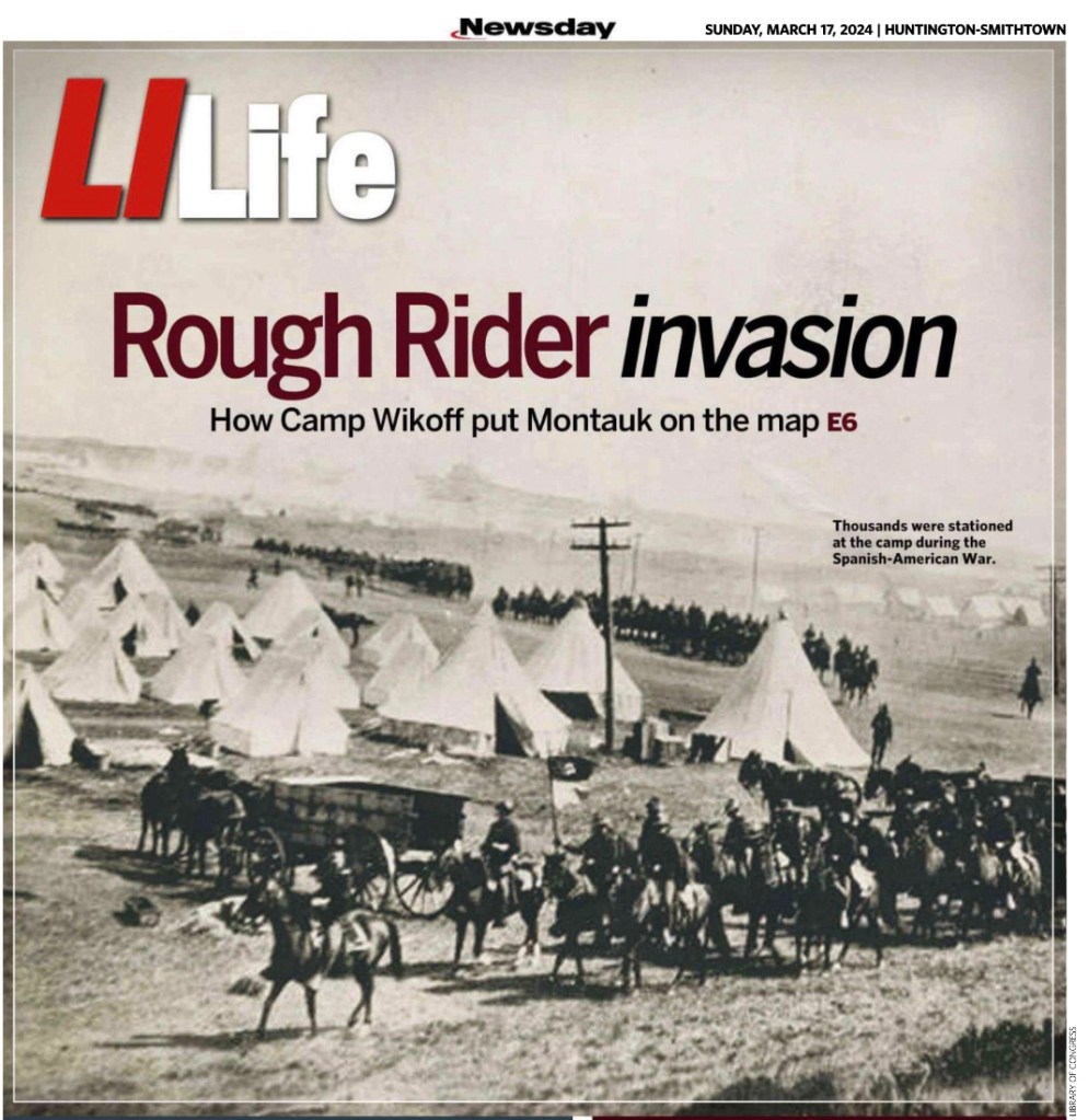
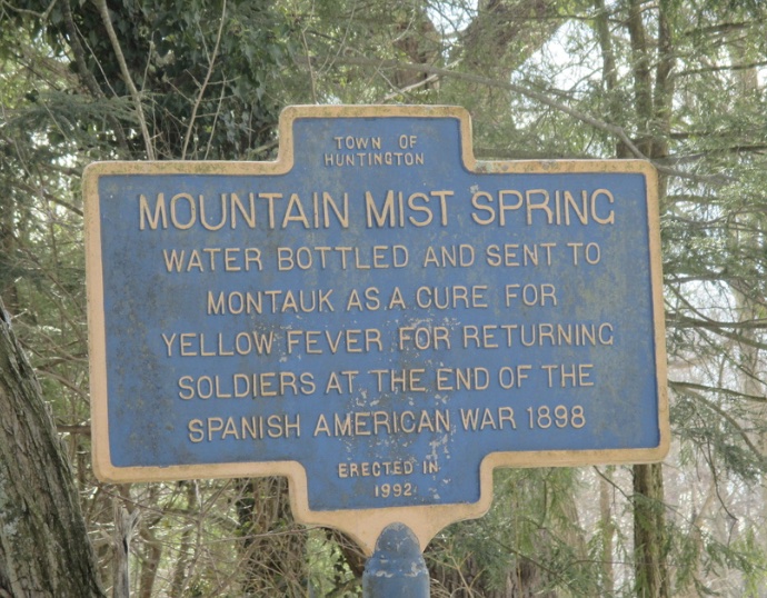
The cover story of Newsday’s March 17, 2024 edition of LI Life highlights the history of Montauk’s Camp Wikoff. The interesting account of the camp where Theodore Roosevelt, his Rough Riders, and other soldiers were quarantined after the Spanish American War did not include the very small role Huntington played in this story.
The first soldiers arrived in Camp Wikoff on August 15, 1898. Within days, the owners of the Mountain Mist Company, which bottled spring water from West Hills, proposed sending their product to the soldiers as a cure for any cases of yellow fever imported to Montauk from Cuba. The Surgeon General accepted the company’s offer of 100 five-gallon bottles of water. The chief surgeon at the Camp Wikoff hospital said the water was “grand” and “thoroughly appreciated by the soldiers.”
The Mountain Mist Company had been formed earlier that summer to bottle the cool, fresh spring water that had been enjoyed for years by locals. Doctors from Huntington as well as New York City endorsed the curative powers of the water to treat various conditions. The company controlled all the land adjacent to the spring and erected a bottling plant on the northwest corner of Sweet Hollow and Chichester Roads. The water was shipped to New York City and Brooklyn for sale as well as to Camp Wikoff.
It is unclear when the company stopped bottling the water. It is still shown on the 1909 E. Belcher Hyde Atlas of Suffolk County. David Wood, who had been in charge of the bottling plant for several years, died in 1907. It appears that he was no longer working for the company when he died, perhaps indicating that the plant was idle before his death.
According to former Huntington Town Historian Rufus Langhans, the bottling plant building was moved to another location and converted into a residence.
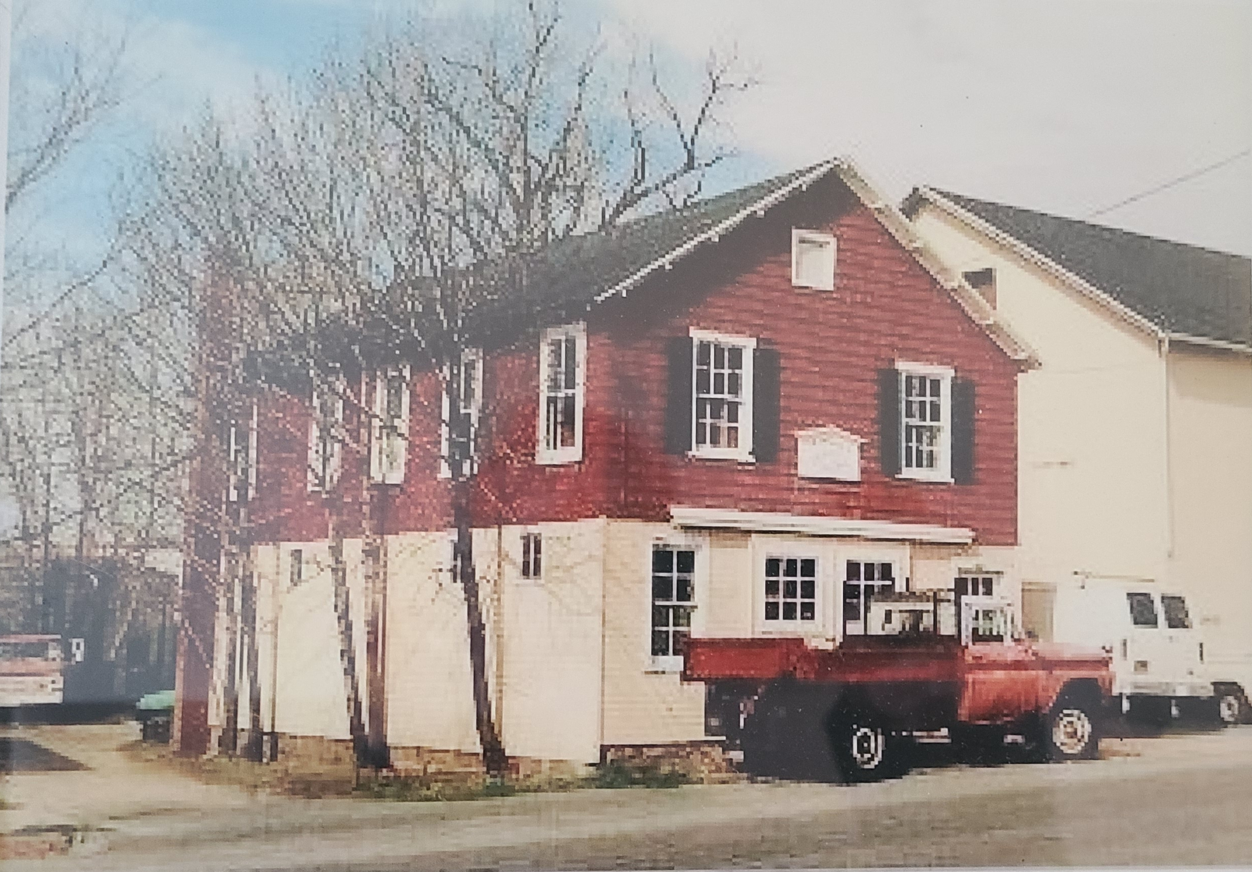
Huntington’s newest designated historic landmark is a small wood framed building that served as one of the last blacksmith shops in Huntington village.
Undated photo of the Edward Place Blacksmith Shop
The building stands on what had been the Zophar Oakley property. The 12-acre site was subdivided by a local real estate syndicate in 1892 (See The Stuart Block). In 1909, William Brahm constructed this building on the east side New York Avenue north of Gerard Street to serve as the blacksmith shop for Edward Place.
In 1911, Frederick Gallienne moved the building to First Street (now known as Gerard Street) onto property Place had acquired from Hiram Baylis. Originally one story, a second floor was added some time between 1914 and 1922.
Sanborn maps show the building changed from one story in 1914 to two stories in 1922.
Place lived on Elm Street in Huntington village, but by the 1920s appears to have lived with his wife on the second floor of the shop. When he died in 1928 at age 55, his address was given as First Street. According to his obituary:
Mr. Place specialized in racing and saddle horses, and on more than one occasion was solicited as horseshoer (sic) on the grand circuit. He had a movable forge and went to various estates to shoe their fancy horses. . . . Mr. Place was always the owner of fast stepping horses, and has won in many racing events. [The Long-Islander, April 6, 1928]
An updated 1930 Sanborn map identifies the building as a dwelling upstairs and a garage on the first floor. According to the 1950 census, Joseph Jordan, an African American chauffeur, lived there with his wife Lula, their nephew, and a boarder and his wife. Later, it was home to James and Clara Selvy, who had lived across the street in 1950.
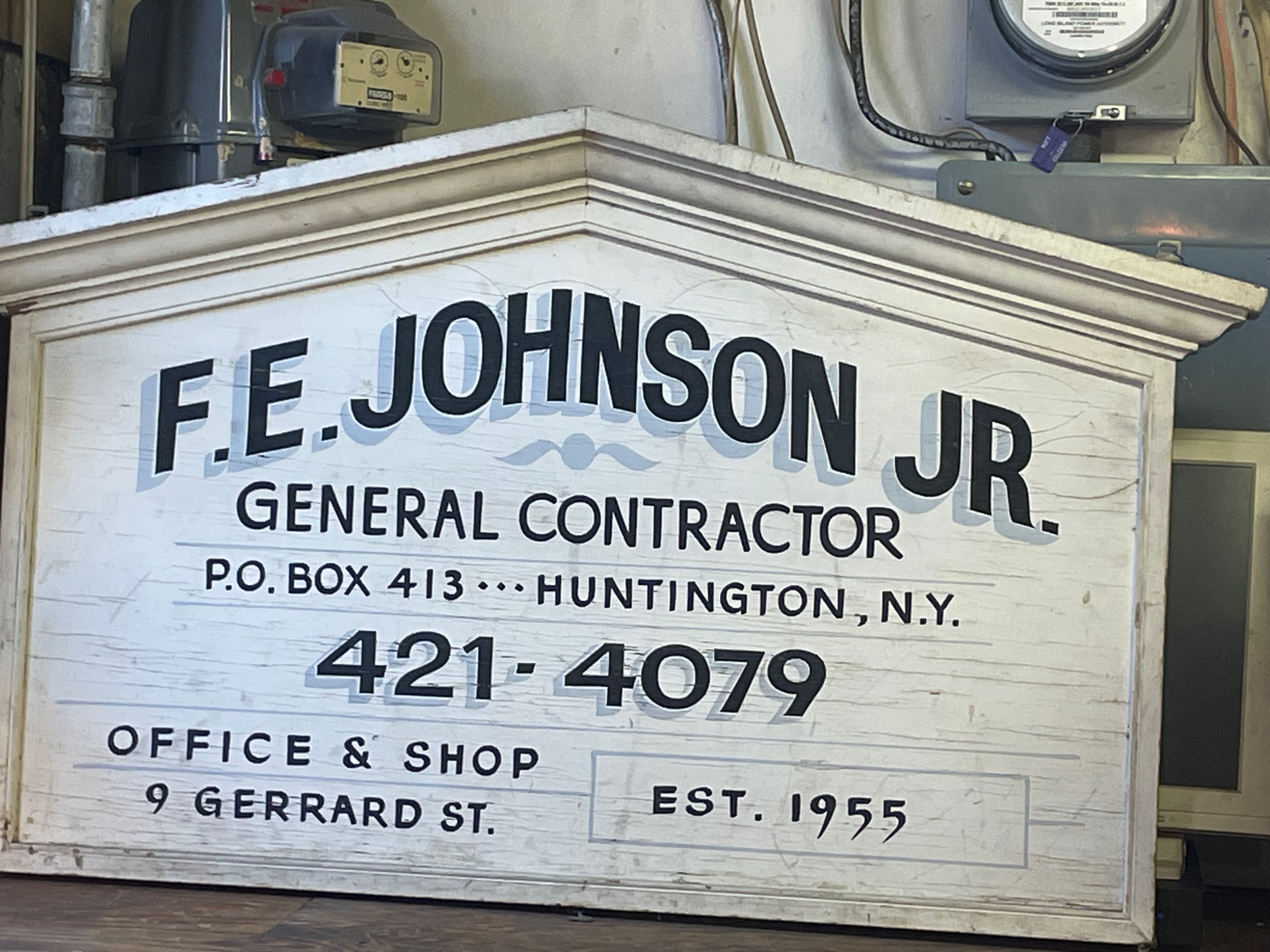
The most recent owner and resident of the building was Frank E. Johnson, Jr., who recently passed away. Johnson acquired the building in 1979 and used the lower level as his workshop for his contracting business. He moved into one of the two second-floor apartments in the mid-1980s.
The Town Board designated the shop as a local historic landmark on March 12, 2024 because it is a unique survivor of Huntington village’s equestrian past. At one time there had been several blacksmith shops and livery stables in the village. Now the Edward Place Blacksmith Shop is the only survivor and the only connection to the days when horses provided the primary means of transportation. It is one of the few surviving wood frame buildings in the downtown commercial center and, as such, has become a familiar feature of the area.
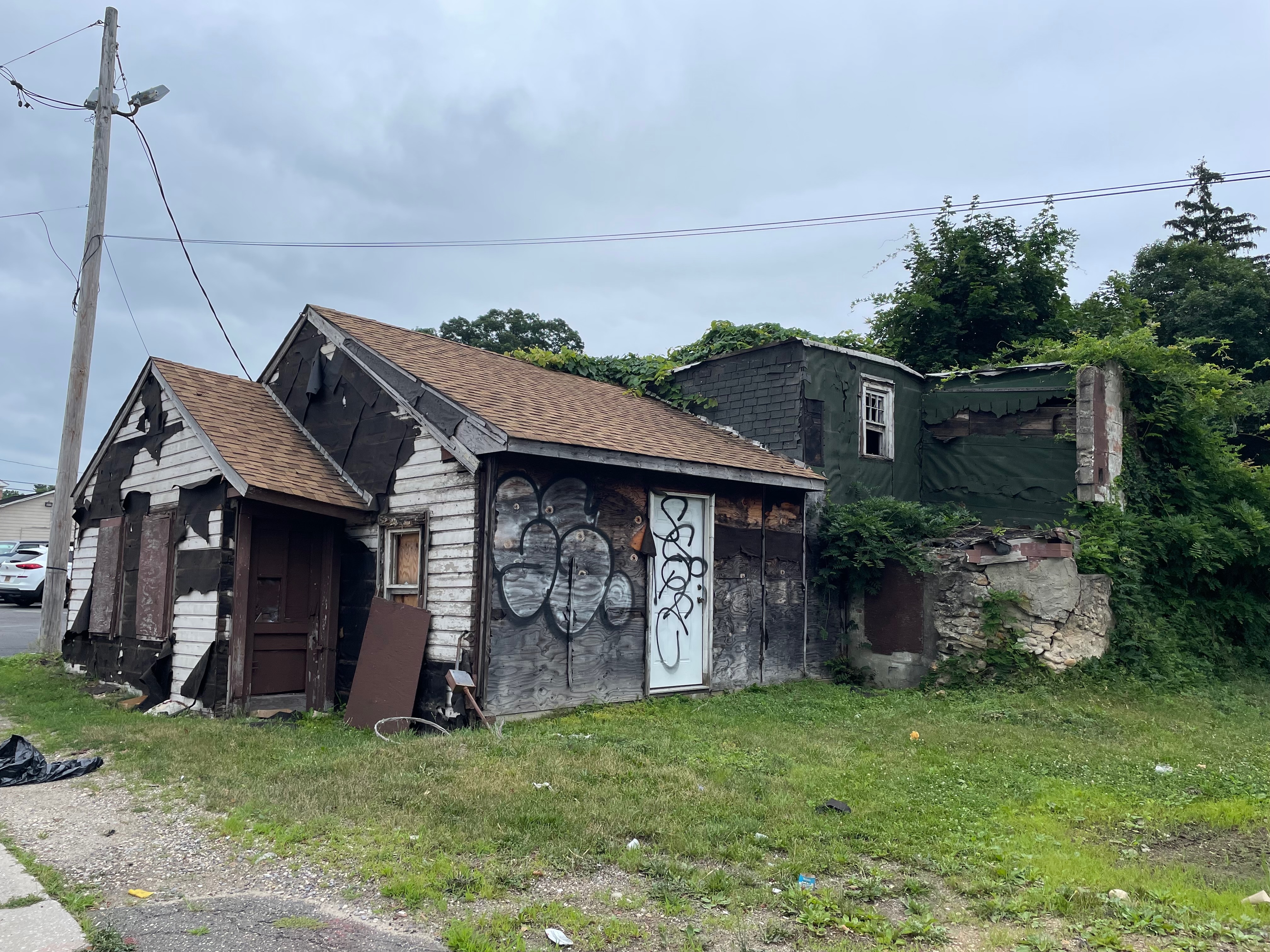
A long abandoned and neglected building on Jericho Turnpike was recently torn down. That fact, in and of itself, would not usually be worthy of comment. But those remains had an interesting history about a man and his love for his wife.
The recently demolished ruins at 504 East Jericho Turnpike
George Eckert moved to Huntington from Brooklyn in 1909, joining his parents who had moved here seven years earlier, when they purchased land on the south side of Jericho Turnpike at Melville Boulevard. His parents, George and Kunienda Eckert, operated a chicken farm and opened the first gas station in that part of town. In 1918, George, Jr. purchased a large plot of land on the south side of Jericho Turnpike between Oakcrest Drive and Melville Boulevard.
The Eckerts ran a small general store known as “Camp Idle Hour.” In addition to providing household necessities, the store telephone was available to local residents who did not have their own telephone lines. Mrs. Eckert ran the store, while Mr. Eckert operated a trucking company between Huntington and New York City. Previously, George had worked for the Long Island Rail Road as a tool and die maker. His son Robert also worked for the railroad. George Eckert was active in the South Huntington Protective League, a civic association formed in 1925 shortly after the merger of the South Huntington and West Hills School Districts and the announcement of plans for a new water district.
Tragedy struck in October 1932, when Mrs. Eckert was hit by a car while helping a little girl cross Jericho. She sustained fractures to her legs and skull as well as internal injuries. She was rushed to Huntington Hospital, but died a few minutes after arriving.
George and his son continued to run the store and gas station until 1934. They then rented the store to various businesses. For many years, it was the location of The Lobster Inn, which remained in business through the late 1950s.
After his wife’s death, George Eckert built a castle as a shrine in memory of his wife. First, he dug a 50-foot diameter moat. Next, he gathered rocks from near and far in his truck to mix with cement to form the walls of the circular castle. In the middle of the three-story castle was a 70-foot tall tree. The first floor of the castle was used for storage and for the coal furnace. The second floor contained a kitchen, bedroom and library. The third floor was partially enclosed and included a roof top garden for Eckert’s plants. The grounds around the castle were described as park-like.
Close up of a section of the building that appears to contain part of Eckert’s Castle
In later years he would retreat to his library, which included hundreds of books on a variety of topics. His family sometimes wouldn’t see him for days. His son Robert lived nearby on the property.
Tragedy struck again in the early hours of February 25, 1950 when a newspaper truck driver noticed flames coming from the castle. He called in the alarm from a nearby restaurant, but by the time the firefighters arrived the fire, which had started in the coal furnace, was out of control. The fire fighters could not enter the building. When they finally were able to gain entry, the 75-year old recluse was found slumped outside his bedroom. He had apparently suffocated.
George’s son Robert continued to live on the property until his death in 1963. Later generations still live in the area.
A barbershop is often a place where stories, gossip, and tall tales are shared. Some are true, some are embellished, and some are just plain wrong. In the case of Cold Spring Harbor’s barbershop, the same could be said about the stories and tall tales told about the shop itself.
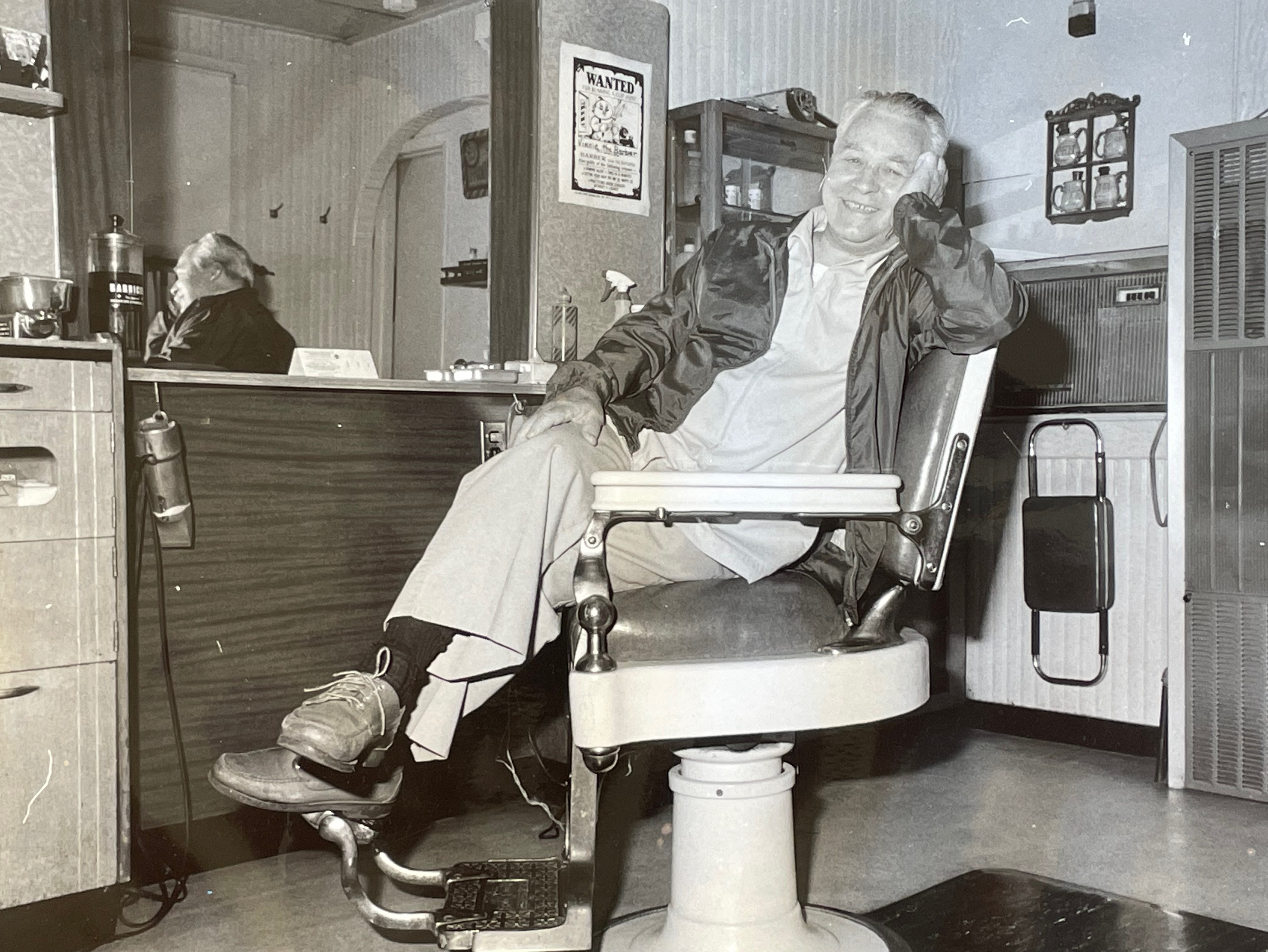
Vinny’s Barbershop, Cold Spring Harbor
Here’s what is said. The small building was moved to Cold Spring Harbor from Huntington in 1890 by Oliver Jones, who took possession of it after the owner defaulted on a mortgage. The building once was the post office and telegraph office. For a period, it housed the local library collection. It was an ice cream parlor and candy shop. A wealthy woman purchased the building, secured a barber, and made provisions that it must always be a barbershop because she was motivated by a desire to keep her husband from traveling to Manhattan for his haircuts and perhaps other pursuits.
Some of that is true.
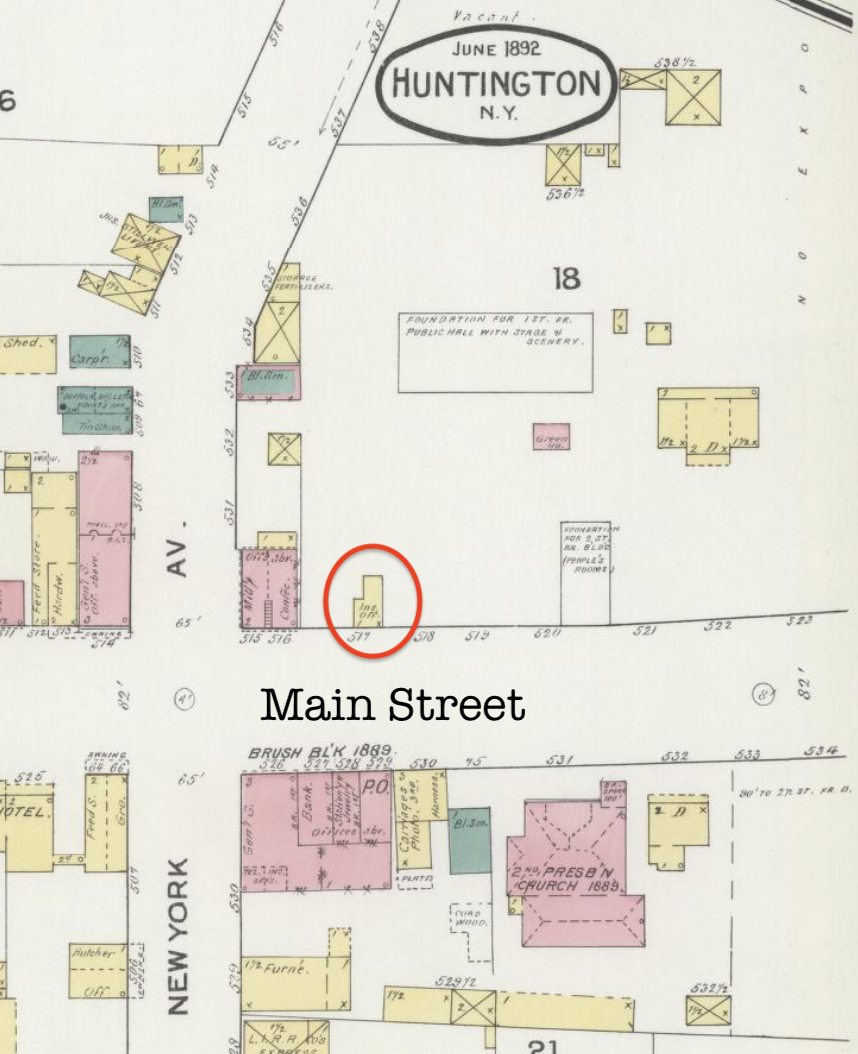
The story begins in Huntington. Hewlett Scudder, not yet 30 years old but from an old Huntington family, was making a name for himself in real estate and insurance. He was described as “tall, well proportioned and passes as a good looking fellow.”[1] In August 1891, he had brokered the purchase of the Stuart property at the east end of Huntington village. The property stretched from New York Avenue to east of the Trade School building at 209 Main Street and as far north as Union Place. He arranged the sale of the property to the Huntington Real Estate Association, a syndicate of wealthy investors that Scudder had helped organize and in which he was an investor.[2] A month later, his syndicate closed on the Temple property on Cold Spring Hill at the other end of the village.[3] Both properties would be divided into building lots and sold to the public or individual members of the syndicate.
The Stuart property investment was wildly successful, the investors made a 93% profit in one year.[4] Now the location of a row of brick commercial buildings, the first building erected on the property after the purchase was “a portable house” built by Scudder to serve as his real estate office.[5] Eighteen months later, Oliver Jones, one of the investors in the syndicate, found out just how portable the house was.
1892 Sanborn Fire Insurance Map showing the Scudder Building at 257 Main Street, Huntington
On August 2, 1892, a year after closing on the Stuart property, Scudder told his wife he was going to Middletown, NJ for business. He never returned. His wife feared foul play. Some suspected suicide because a relative had committed suicide a month earlier. Others alleged he fled debts he could not pay. Indeed, when Charles R. Street, a lawyer hired by Scudder’s wealthy uncle, examined Scudder’s books, he found debts of $6,500 (for comparison, the Stuart property had been purchased for $20,000). Scudder had borrowed heavily from the Bank of Huntington. His notes were endorsed by many of the well to do of Huntington. “The night before leaving town Scudder borrowed money wherever he could get it, and had several checks cashed, overdrawing his account considerably.”[6] Cash paid for lots in the Temple property received days before Scudder disappeared could not be found.[7]
How had such a successful young man amassed so much debt? Reportedly, Scudder was a regular participant in a nightly high-stakes poker game in the village. He also liked to bet on horse races. Apparently, he was not as successful with his bets as he was with his real estate career. The biggest loser in this mess—other than Scudder’s wife—was Dr. Oliver L. Jones, one of the investors in the real estate syndicate and owner of the property on which Scudder had built his “portable house.”[8]
While things were being sorted out, the small building was rented to Edward Johnson to use for a fish and vegetable market.[9] In the spring, Jones hired William Bingham to move the building to Cold Spring Harbor “to be used for a post office and telegraph office.”[10]
The building was moved to property on the south side of Main Street opposite Shore Road. The 40-acre property on which the building now stood had long been owned by the Conklin family. That property had been purchased from the estate of Elizabeth Conklin, widow of Richard M. Conklin, by Charles H. Jones in 1879.[11] Jones died three years later, and the property was inherited by his daughter, Mary E. Jones, wife of Oliver L. Jones.
The first use of the Scudder building after it was moved to Cold Spring Harbor was to serve as the local Western Union telegraph office. Eva Wright was the operator. With the onset of colder weather in October 1893, Miss Wright moved operations to her father’s house because Western Union did not supply coal to heat the Scudder building. She moved back to the Scudder building the following March.[12] The post office was moved into the building in March 1897 following the 1896 fire that had destroyed its previous location at the Seaman & Bennett’s store, which was located on a pier where the Seafarer’s dock is now located.[13] That post office, and the store, were destroyed by a fire set by robbers in November 1896. After the fire, the post office was relocated to the Scudder building.[14]
George Bennett bought out Seaman and built a new store, with a second-floor apartment for his family, to the east of the Scudder building. The new store was completed by March 1897.[15] For a few years, while the building was the post office, it also housed the small book collection of the Cold Spring Harbor library. The land on which Bennett built his store continued to be owned by the Jones family. In 1910, the post office was relocated to the Holmes building at 90 Main Street.[16]
While a definitive timeline has not been established yet, the old Scudder building eventually was converted to use as a barbershop. Jack Sloter was the first barber to use the building. Sloter had been a resident of Cold Spring Harbor since at least 1892.[17] In 1894, he was described as “the popular Main St. barber,”[18] but his shop was not yet located in the Scudder building. There were also barbers at the Glenada Hotel and at Van Ausdale’s.[19]
Sloter, who was from Brooklyn, married Jennie Jones, the daughter of John and Elizabeth Jones of Cold Spring Harbor, in 1894. The couple lived in Cold Spring Harbor since their wedding.[20] From 1918 to 1948, Sloter also worked as a custodian at East Side School.[21]
When Sloter set up shop in the Scudder building is not known. It had to be after the post office vacated the building in 1910. In 1908, Sloter moved his shop to the Valentine building.[22] The Valentines owned property on the south side of Main Street, east of Shore Road. Sloter may have moved across to the north side of Main Street sometime between 1908 and 1921. In 1921, there was a report of an attempt “to jimmy the door of the barbershop of John Sloter, near the Lockwood and Carley residences.”[23] A small, one-story building is shown on the 1917 Sanborn fire insurance map at 103 Main Street, next to the Lockwood residence at 117 Main Street. This may have been where Sloter’s barbershop was in 1921.
Jennie & Jack Sloter at their 55th Wedding Anniversary in 1949
However, reports of another burglary in 1924 seem to place Sloter’s shop at the Scudder building. The burglar not only broke into Sloter’s barbershop and cigar store, he also broke into Jennie Sloter’s ice cream and tobacco store, located “some 25 feet distant.”[24] The juxtaposition of the two shops is consistent with the positions of the Scudder building and the Teal building. In 1911, Edgar Shadbolt had opened an ice cream parlor. Previous accounts have given the location of the ice cream parlor as the former Scudder real estate office building. But the Sanborn fire insurance map for 1917 shows the ice cream parlor in the Teal building next door to the south. That building had served as Cold Spring Harbor’s first firehouse from 1896 to 1906. The Teal building was also owned by Jones.[25]
1917 Sanborn Fire Insurance Map
A car accident in 1929, clearly locates Sloter in the Scudder building. A truck turning from Shore Road onto Main Street was struck by a car traveling west on Main Street. The car “struck the truck midway and drove it to the south side of the road, overturning it in front of the show window of Sloter’s store.”[26]
After Sloter died in December 1951, Sam Ryan took over as Cold Spring Harbor’s barber.[27] In 1964, Ryan was joined by Vinny Hayes, who assumed ownership of the shop a few years later.[28] Vinny’s daughter, Jennifer, joined him in 1991 and took over when he died in 2003.
One of the first issues to confront Vinny Hayes when he took over the shop was the expansion of the 1930 firehouse next door. In 1922, the estate of Mary E. Jones sold the land on which the barbershop and the store built by Bennett stood to Stephen A. Pedrick.[29] Pedrick had been a clerk in the Seaman & Bennett store starting in 1892 when the store was located on the pier where Seafarer’s dock is now located. In 1906, Pedrick purchased from Bennett the new store Bennett had built in 1897.[30] Pedrick’s 1922 purchase from the Jones estate included his store, where he also lived, and the barbershop building.
Vinny Hayes 1989
In 1969, the fire district proposed building an addition to the 1930 firehouse to accommodate its larger fleet of fire fighting equipment. District voters had rejected a proposal to tear down the 1930 firehouse. A second vote to acquire the Pedrick property and build an addition to the firehouse was approved by the voters.[31] To make room for the expanded firehouse, the Bennett/Pedrick store was demolished, and the barbershop building was moved to the east of where the Bennett/Pedrick store had been. The new firehouse addition was dedicated at an open house held for the community on January 31, 1971.[32]
Jennifer Hayes continues to cut hair as the fourth proprietor of Cold Spring Harbor’s historic barbershop. Like any good barbershop, it is the place to catch up on the latest local news and gossip, notwithstanding tales of a wealthy woman conspiring to keep her husband from wandering into the City to get a haircut.
[1]The Brooklyn Daily Eagle, August 7, 1892, page 15
[2]The Times Union (Brooklyn), August 11, 1891, page 2.
[3]The Times Union (Brooklyn), September 15, 1891, page 5.
[20]The Long-Islander, June 15, 1934, page 12; The Long-Islander, June 5, 1925, page 4 (report of Mrs. Sloter’s brother’s death identifies their parents).
[21] The Long-Islander, February 1, 1918, page 7; The Long-Islander, February 5, 1948, page 15
[23]The Long-Islander, April 1, 1921, page 11. The burglar turned out to be George Hawxhurst, a 27-year-old blind man who lived where the current post office is located, New York Herald, March 30, 1921, page 1.
[24]Brooklyn Times Union, September 2, 1924, page 3
Generations of the Funnell family lived and worked on what they called Strawberry Hill. Today their homestead is best known as the home of Main Street Nursery.
In 1853, Henry Funnell placed a notice in The Long-Islander newspaper announcing that he was moving his candle manufacturing business to a location half way between Huntington and Cold Spring Harbor. In addition to making candles, he also sold strawberry plants and called his new home Strawberry Hill.
Henry and his wife Mary had immigrated from England in the 1840s. They had thirteen children. When they moved to Strawberry Hill, they occupied the George C. Wood property. The family later acquired land on the north side of West Main Street near what is today the entrance to Huntington Country Club. George Wood ran a livery stable in Brooklyn, but returned to Huntington after the Civil War. The widowed Wood later married Henry Funnell’s daughter Anna Maria, who was 25 years younger than he was.
Henry’s son Henry T. Funnell trained as a schoolteacher and taught in Binghamton. He later became Superintendent of Schools there and also taught at Oswego. He returned to Huntington shortly after the Civil war to take over his father-in-law’s drug store in Huntington. He continued to be involved with education as a member of the Huntington Board of Education.
Around 1892, he turned active management of the drug store over to his son Harry and went into the florist and nursery business with his son Archibald. Their first greenhouses were located north of Main Street behind what is now Rosa’s Pizza. Henry T. died in 1912. Archibald continued the business. In 1927, he opened a florist shop next to the family pharmacy at 306 Main Street in Huntington. Later he built greenhouses at the family property on West Main Street. In 1950 he moved the florist shop there as well. It was located in the small building at 477 West Main Street that is now home to DeLuca Designs. Archibald continued to operate the business until the early 1950s.
Henry T’s sister Esther lived in the house that is now Main Street Nursery. The house was built in 1876 for Esther and her husband George W. Barrett, who had been a whaler. Over the course of 12 years before the Civil War, he shipped out on three whaling voyages. It is said that he along with five other men formed “the heaviest boat crew ever lowered in pursuit of a whale.” None of the six weighed less than 225 pounds. Barrett commanded a steamship for the Navy during the Civil War and later was a captain on coasting vessels. He spent 50 years on the sea.
Henry T. Funnell lived in the house next to the entrance to the country club. That house was designated a Huntington Historic landmark in 1993. The next house was owned by Henry T’s brother John George Overton Funnell, who was a carpenter in Brooklyn. On the bottom right is the house of George and Esther Barrett. Photo courtesy of the Huntington Historical Society.
George Barrett died in 1908. Esther continued to live at the house until her death in 1924. Their son Frank later sold the house and it changed hands several times. According to an account written by Henry T.’s granddaughter, the Barrett house eventually ended up in the hands of “an unsavory character,” whom she did not identify.
That “unsavory character” was Nicholas Radano.
Radano turned the Barrett house into Nick’s Inn, which became the site of various nefarious doings over the years, including selling liquor in violation of Prohibition and operating a disorderly house. Nick’s Inn attracted many visitors, including the police, who raided the place on several occasions.
In June 1931, Radano was acquitted on a charge of selling liquor in violation of Prohibition laws. Radano had previously been convicted of “manufacturing alcohol, maintaining a nuisance and possession of a still.”
The month after his acquittal, the Inn was raided, and Radano was taken to Brooklyn to be questioned by the police as a material witness in connection with the murder of gangster Anthony Capato, an associate of Al Capone. During a search of the house, the police found several guns, two night sticks, and a slot machine. A revolver found at the Inn was taken to Brooklyn to see if it matched the bullets in the body of the murdered gangster. Radano paid a $50 fine for possession of the slot machine. The gun charge was dismissed for lack of evidence. Apparently, the bullets from the revolver found at Nick’s didn’t match those used in the murder.
Nick’s was raided again in September 1932 and Radano was charged with maintaining a disorderly house, which could mean operating a brothel, and violating New York’s gun law. Liquor was also found on the premises. Radano was again charged with maintaining a disorderly house in March 1934. He pled guilty to that charge and was fined $200 and given a one year suspended sentence.
Nick’s attracted unwanted guests other than the police. In September 1934, four men entered the Inn shortly after midnight and announced a stick-up. The thieves took cash from the bar’s patrons as well as the cash register. Then the thieves led the male patrons to an upstairs bedroom and told them to remove their pants. They were then tied to the bed. The thieves escaped before the police could be called.
Later that year, 42-year-old Radano married 28-year-old Dorita Armstrong, who had also been taken to Brooklyn for questioning after the 1931 raid. It was Radano’s second marriage. His first wife divorced him in 1932, at which time he was already living with Armstrong on Carley Avenue, around the corner from the Inn.
Married life didn’t mean the end of Radano’s run-ins with the law. In 1936, the restaurant, now called the New Garden Inn, was raided at 1:00 in the morning. Radano and a woman named Betty Fritz of Manhattan were arrested. Radano was charged with violating the Mann Act, which made it a felony to transport a woman over state lines “for the purpose of prostitution or debauchery, or for any other immoral purpose.” Radano pled guilty and was sentenced to 18 months in jail and a fine of $2,000.
Radano was back in Huntington by the beginning of 1939, when he was arrested again. This time the charge was brought by his wife, who alleged that he struck her in the face with his fist. A few months later, he ran afoul of the town zoning code by building an addition to a stand on his property without a permit.
In 1947, Dorita applied for permission to construct an addition to the house for use as a restaurant. Neighbors objected arguing that the non-conforming restaurant use had lapsed during the war. The application was denied. The Radanos operated a refreshment or vegetable stand on the property for a few years.
By 1956, Gerry and Addie Raynor acquired the property as well as the Funnell greenhouses. They operated a successful nursery until they retired in 1974. As Bertha Funnell wrote, “Trees, nursery stock and flowers once more graced the neighborhood. Respectability and dignity returned to the Barrett property. The nursery business has continued under various owners to this day.
The two other Funnell houses remain private residences.