Feeds:
Posts
Comments

Archive for the ‘Huntington People’ Category

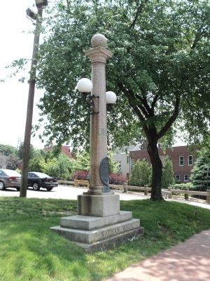
For the first time in over sixty years, the lights on the Nathan Hale Memorial on Main Street in Huntington village are lit.  Lights were an original feature of the memorial, but they have not worked since at least 1954.

The monument lights working for the first time in over 60 years.

The monument lights working for the first time in over 60 years.

How the lights came to be restored is a story that starts in June 2013 when I posted an article about the Nathan Hale memorials in Huntington.  The article focused mostly on the famous Nathan Hale Rock and only briefly mentioned the memorial on Main Street in front of the Soldiers & Sailors Memorial Building.  One reader took me to task for not giving the monument on Main Street its due:

I’m not sure you do full justice to the memorial by calling it “a marble shaft” … yes that is what it is today but in its early days this Nathan Hale Memorial functioned as a PUBLIC DRINKING FOUNTAIN.

Of course, the reader is correct, the monument was originally a fountain (he could have also chastised me for writing the shaft is marble–it is, in fact, granite).

In his comment, the reader cites the 1919 edition of  Automobile Blue Book (“Standard Road Guide of America”), which mentions “a public drinking fountain on a marble shaft” (I wasn’t the only one who had trouble correctly identifying rocks) as one of the things to see when driving to Huntington.  The reader continues:

I have seen photos of the memorial from a little over a decade after it was erected (c.1905) that refer to it as the “Nathan Hale Memorial Drinking Fountain” but the photos do not give a clear enough detail of the memorial to see much about the fountain at the bottom. It does seem that the water basin that once caught the drinking water has been long ago removed. I assume it had a hand pump and was a well water drinking fountain originally but cannot make out a hand pump on the photos from the angles they were taken. (Photos from the 1940s/1950s, or about that time, appear to no longer show the water basin at the bottom).

* * *

Does anyone know any more about this memorial … like, for instance, when the drinking fountain was removed … and if there has ever been an attempt, over the years, to return it to its original function as a public drinking fountain (with maybe modern running water piped to it but activated by an ‘old fashioned style hand pump’ and a replica of the water basin ‘returned’ to the base … to keep it in the original flavor of the 1894 monument.

Here, as they say, is the rest of the story.

Soon after the statue of Nathan Hale was unveiled by the Sons of the American Revolution in City Hall Park in Manhattan on Evacuation Day (November 25), 1893, an effort was made to create a monument to the spy in Huntington, where he began (and maybe ended) his spying mission.  Famed architect Stanford White of McKim, Meade and White submitted the design and pledged $400 for the project.  The total cost of the memorial was estimated to be $1,900.  An association was formed to raise the remaining funds.  In April 1894, the association printed a brochure announcing the project and listing 52 Huntington residents who had pledged to donate to the project.  Pledges ranged from 50 cents to 100 dollars and totaled $813.50.  It was proposed that the balance should be donated by “the rest of Long Island and the sympathizers with the fate of Nathan Hale wherever they may be found.”

Stanford White proposed design.

Stanford White proposed design.

Whoever and wherever they were, the memorial was unveiled at a well attended public celebration on July 4, 1894.  The Long-Islander provided a full description of the 15-foot high monument:

The base is six feet square and of rough hewn stone.  It is hewed for a public drinking fountain and has two basins.  The one on the street side is a watering trough for horses or cattle and the one on the inside is for the people.  The water will flow into the street basin from the mouth of a dolphin and into the other smaller basin from the mouth of a lion.  Above the basin reaches a cylindrical polished granite column and on that rests a large rough-hewn ball.  On the front of the basins are engraved the simple words:

NATHAN HALE MEMORIAL

The memorial conveys the impression of dignity and simple beauty.

The shaft also held two lamps on either side.  It is unclear whether they were gas lit or electric.

Town Supervisor George Tileston accepted the monument “on behalf of the citizens of Huntington.”

“We accept it as a perpetual trust, engaging with you [the committee that commissioned it] that it shall be a continued inspiration to us and all those who shall come after us.”

After speeches and the unveiling of the flag draped memorial, the crowd assembled at the carriage factory on Wall Street for dinner.

The July 4, 1894 dedication of the new memorial

The July 4, 1894 dedication of the new memorial

Not all were so enamored of the monument.  Writing to the Brooklyn Daily Eagle two months after the dedication, “Burdock” reports that the people of Huntington “are generally exercised over” the new memorial.  His description  differs from the one given by the local newspaper.  Burdock reports that the monument “consists of a lamp-post, with two lamps, a spout for water from the post, and a drinking trough for horses, combined.”  He seemed most upset with the inscription: “To commemorate the capture of Nathan Hale by the British on the shores of Huntington bay in 1776.”  To Burdock, the inscription sounded like a Tory boast about the capture of the failed spy.

Burdock predicted the monument “would always be an annoyance and source of mortification to the people of the town as a whole, and probably is now to those who made such an almost unpardonable mistake, not only in the design, but in the inscription, which are in keeping with each other.”

The monument with the water trough for horses

The monument with the water trough for horses, note the marble tablet above the trough


The south side of the monument showing the drinking fountain for people.

The south side of the monument showing the drinking fountain for people.


The now dry lion head spout on the south side of the monument.

The now dry lion head spout on the south side of the monument.

There is no evidence of a hand pump in the photographs and the early descriptions of the monument refer to water pipes.  It would appear that the water was supplied by the Huntington Water Works Company.  But the supply was inconsistent at best.  A mention in the May 26, 1905 edition of The County Review, reports that “Huntington has a dry fountain. . . .  It is a curious sort of fountain for there is no water to be obtained there and the affair is an ornament only.”

Five year later, a Huntington resident wrote to The Long-Islander to complain about the condition of the monument.  The writer admires the monument, “the very interesting, and most artistic, double lantern, and drinking fountain.”  However, he questioned who has the responsibility for maintaining these monuments: “We notice the lanterns are falling to pieces owing to the lack of proper paint.  The glasses are broken, and the general immediate surroundings are in need of attention. * * * The lanterns would seem less pathetic if they might be put to their proper use, that is have lights in them, if only for a part of the evening.”

The writer also notes that the librarian (the library was then located in the nearby Soldiers & Sailors Memorial Building) placed a cup at the fountain on several occasions so that people could use the fountain as intended.

Two years later, the Daughters of the American Revolution and the Sons of the American Revolution both took up the matter of the condition of the monument.  By this time, not only were the lamps in poor condition, but the marble tablet with the inscription had fallen from its place and was broken.

The monument without the marble tablet

The monument without the marble tablet

The DAR address the matter first at its meeting in the afternoon of Monday, November 11, 1912.  The DAR appointed Mrs. John F. Wood to confer with the SAR about the matter.  That evening the SAR met and discussed the matter.  Conveniently they appointed John F. Wood (and Douglass Conklin) to confer with the DAR ladies.  The plan they decided on was “to replace the broken tablet with one of bronze, fix up the lamps, fountain, etc.”  The Huntington Light and Power Company offered to attend to the lamps and keep them lighted.  After the repairs were done, it was agreed “to turn the whole thing over to the town.”  It seems to have been forgotten that the Town accepted the monument “as a perpetual trust” in 1894 and was probably the entity that should have been making the needed repairs.

The fountain without the marble tablet.

The fountain without the marble tablet or the dolphin spout. A spigot can be seen on the south side.

I have not found a report of when the work was completed.  But the next summer, the fountain was still dry.  Even though, as one letter writer observed, the reservoir on High Street was known to overflow.  “The poor struggling Water Company can’t even let a little of this ‘waste’ flow into the Nathan Hale Memorial Fountain, so at least the horses and dogs can quench their thirst during the hot summer months.”

At some point, the water trough was removed.  With the advent of the automobile, there weren’t as many horses around needing a drink (one local historian said that in later years the water trough was used more for cleaning out radiators than for quenching a horse’s thirst, but that account may be apocryphal).  The trough also took up a parking space–a valuable commodity even then.  The date the trough was removed has not been found.  A photograph of the monument sans trough includes cars from the late 1920s.

Postcard from the late 1920s

Postcard showing a 1926-27 Ford Model T and the modified memorial.


The monument without the water trough. Note the new bronze plaque replaced not only the marble tablet but the dolphin water spout.

This close-up from the picture above shows the monument without the water trough. Note the new bronze plaque replaced not only the marble tablet but the dolphin water spout.  The light fixtures have also been changed.

In 1954, the State undertook a project to reconstruct Route 25A, Main Street, from Cold Spring Harbor to Fort Salonga.  In Huntington village, the project required that the monument be moved from its original location.  At first the State was going to move the monument back from the street and slightly to the east, but eventually moved it to the west instead.  The construction plans for the project detail the memorial, but with the light fixtures hanging down rather than up, and indicates the “assumed location of light service,” i.e. the location of the electric lines supplying power to the light fixtures.

The comment quoted above led not only to further research (and this post), but also led me to ask the Town’s Department of General Services to see whether the lights could be turned on.  Recent work by Brian Breyersdorf, an electrician in the Town’s Department of General Services, revealed that wiring had been run through the monument and left coiled up buried in the ground next to the base of the monument.  The lights have not worked because they were never plugged in after the monument was moved in 1954!  Mr. Breyersdorf installed a junction box to connect the wire in the memorial to new wire from a nearby light pole. And now the memorial has regained at least part of its original embellishments.  On December 22, 2015, the lights, now with L.E.D. bulbs, shone brightly for the first time since the monument was moved. It is doubtful the water trough will ever be re-established.

There has been one other change to the monument that is not as obvious as missing water troughs and non-functioning lights.  The original marble tablet and the bronze replacement from 1912-13 asserted that Nathan Hale was captured on “the shores of Huntington bay.”  Today, the bronze plaque says he was captured “on the shores of Long Island.”  It is unclear when this change was made.  The controversy about Hale’s place of capture, however, is an old one.

The revised wording

The revised wording

As early as the 1890s, historians questioned the assertion that Hale had been captured in Huntington.  But those naysayers didn’t deter Huntingtonians from dedicating two memorials.  A book published by Henry Johnston in 1901 and revised in 1914 also questions Huntington as the place of Hale’s arrest.  The issue seems to have been forgotten or ignored until 1933 when the Huntington Historical Society revisited the issue.  In the first three months of that year, Mrs. Warren P. Kortright, Mrs. George P. Kuzmier, and Mrs. George Taylor presented papers on the life of Nathan Hale.  A small book of their research was published in April.  The historical society did not offer a definite opinion on where Hale had been captured, but did question the veracity of the sources traditionally cited in support of a Huntington capture.

Town Historian Romanah Sammis then took up the issue, urging the Town Board to correct the mistakes of the past.  As is usually the case in these situations, the party arguing for a change from the accepted story has the burden of proof.  A committee appointed by the Town Board found that Mrs. Sammis had not met the burden of proof required to overturn long accepted story that Hale had been captured in Huntington.

More recent scholarship continues to doubt the Huntington version.  For example the recently published Washington’s Spies: The Story of America’s First Spy Ring, by Alexander Rose asserts that Hale was captured closer to Manhattan.  Another, less scholarly book, The Life and Death of America’s First Spy: Nathan Hale, by M. Williams Phelps argues that Hale was indeed captured in Huntington.  Interestingly, both books rely on a recently discovered manuscript donated to the Library of Congress in 2000.  The manuscript is an account of the Revolution written during the war by Consider Tiffany, a Connecticut merchant and Tory.  Tiffany describes Hale’s capture by Major Robert Rogers. British naval records indicate that Rogers went ashore at Sands Point just three days before Hale was captured.  It is, therefore, most likely that Hale was captured by Rogers closer to Flushing then to Huntington.

The truth of the matter may never be known with certainty.   Perhaps for that reason,  someone decided to hedge things by changing the wording on the bronze tablet from “on the shores of Huntington bay” to “on the shores of Long Island.”  While I have found nothing in the files to indicate when or who made the change, it must be noted that the bronze tablet with the revised wording includes two medallions cast during the Bicentennial.  The moving force behind those medallions?  None other than former Town Historian Rufus Langhans.  Historian Richard Welch confirms that Mr. Langhans told him that he had the wording changed.


Read Full Post »

Well into the twentieth century, the open level land in the Elwood-East Northport area was used for farming.  The post-World War II population boom on Long Island saw these farms sprout houses instead of crops.  Few remnants of the area’s earlier history remain.  There are a couple of historic houses on Elwood Road, but little else.

Tucked away in a 1963 subdivision bordered on the west by Elwood Road and on the south by Cedar Road is an unexpected historic site—a cemetery.  It was not unusual for local families to set aside a patch of ground as a place of burial for one family or for several.  In fact, throughout the Town of Huntington, there are 56 such historic cemeteries.  Most are very small—one has only one grave.  Many are landlocked in someone’s backyard.  The cemetery on Foothill Lane sits on a half acre plot with full access from the street, just like the houses in the neighborhood.  It is almost as if the builder forgot to build a house on one of the lots.

One of the newly reset markers

One of the newly reset markers

On this half acre parcel are five intact gravestones, five broken stones, and one fieldstone marker.  The five intact stones mark the graves of seven members of the Totten family who died between 1902 and 1946.  There is no indication of who the Tottens were; but it is reasonable to assume knowing the history of the area that they must have been local farmers in the days before suburbanization.  However, the atlases of 1909, 1917, and 1931 do not show the name Totten on any of the nearby properties.

Further research reveals that these Tottens were not local farmers—they weren’t farmers at all.  They lived in Brooklyn, but they had deep roots in Elwood.  When they died, their families brought the bodies back to be buried with their ancestors.

In the early twentieth century before suburbanization, amateur genealogists would visit old cemeteries such as this one and record the names on the stones.  Thanks to that work, we know of six other people buried at the Totten Cemetery.  From the names on the grave markers, along with the names recorded nearly a hundred years ago, we know that these members of the family are buried here:

  • Ruth Totten, wife of Nathan Totten (c. 1762-1809)
  • Nathan Totten (c. 1793-1864)
  • And his wife, Lavina Totten (c. 1793-1869)
  • Peter D. Totten (c. 1800-1871)
  • And his wife, Sarah W. Totten (c. 1809-1843)
  • Nathan M. Totten (c. 1818-1851)
  • Charles Mortimer Totten (1831-1918)
  • And his wife, Margaret Anna Totten (1842-1925)
  • Orlando S. Totten (c. 1836-1902)
  • And his wife, Phebe M. Totten (c. 1839-1924)
  • And their daughter, Emma Totten (1862-1946)
  • Gilson I. Totten (1837-1916)
  • And his wife, Mary E. Totten (1840-1909)

Now that the dates are earlier, it makes sense to consult earlier maps.  The name Totten does not appear in this area on the 1858 or 1873 atlas.  But the 1837 Coastal Survey shows a Totten house on the north side of Cedar Road near where Greenvale Drive is today—about 640 feet southeast from the cemetery.  Census records and newspaper articles provide clues to the family.

The 1790 census lists a Nathaniel Totten as a head of household living with a woman over the age of 16, presumably his wife.   The early census takers did not gather much information about those they were recording.  But from this meager record, we know that the Totten family had a long history in Huntington.  The Ruth Totten listed above, who died in 1809 at the age of 47, was probably Nathaniel’s wife, assuming the Nathaniel on the census is the same as the Nathan on Ruth’s grave stone.

Nathan(iel) and Ruth seem to have had at least two sons Nathan born circa 1793 and Peter born circa 1800.  In 1850, Nathaniel Totten, Jr. (there’s that inconsistency in the names again) and his wife Lavina defaulted on a mortgage.[i]  Two farms, one 10 acres, the other 12 acres, were to be sold at public auction.  The 10 acre farm was located on “the highway leading from the Dwelling House of said Nathan Totten, Jr. [the name changed from one line to the next within the printed notice] to the house of Isaac Buffett.”  That would be Cedar Road.

A third Nathan Totten died in 1851 at the age of 33.  He may have been the son of the Nathan Totten who defaulted on the mortgage.  This third Nathan was deaf and mute.  His wedding in 1844 to Mary Emma Mitchell, also deaf and mute, received notice in the local papers because the ceremony was communicated to the bride and groom by sign language.[ii]  Nathan was a teacher at the unfortunately named Institution for the Dumb in New York City and later at the Institution for Deaf Mutes at Jacksonville, Illinois.[iii]   Nathan died in Brooklyn.  “His remains were taken to Comac for interment, of which place he was a native.”  Today we would not call this area Comac, as Commack used to be spelled, but place names on Long Island can be ill-defined.  For more about place names, see the entry “By Any Other Name,” posted on this blog in April 2011 (https://huntingtonhistory.com/2011/04/12/by-any-other-name/).

Nathan and Lavina were the parents of Charles Mortimer Totten (1831-1918) and Orlando S. Totten (1836-1902), who were living together in Brooklyn in 1865 with their mother Lavina.  The brothers were both listed as milkmen.  By 1900 Charles was living in Babylon.

The second son of the Nathan listed on the 1790 census was Peter.  He moved with his young family to Brooklyn in 1840.  His son Gilson was born in 1837.  Gilson’s obituary identifies his mother as Julia Ackerley Totten.  Peter D. Totten is buried here with his wife Sarah W. Totten.  It seems Peter must have remarried.    On the 1855 New York State census, the 53 year old Peter is listed as a widow and living with Clark Ackely, presumably his brother-in-law (the spelling of name son census records is not always accurate).  The 1855 census indicates that Peter and Gilson shared the same occupation but it is difficult to make out the handwriting to see what it was.

From Gilson’s obituary, we can see that Peter eventually became a coal merchant and that Gilson followed him in that business.  Gilson was also very active in the Baptist Church and served for several years as a director of the Dime Savings Bank of Williamsburg.[iv]  Reflecting the confusion of place names on Long Island, the newspaper reports that Gilson would be buried “at Elwood, Dix Hills, East Northport, L.I.”

Now thanks to an Eagle Scout project by Derek Capri, the final resting place of the Totten family has been cleaned up, stones reset, and the family’s story (in part at least) revealed.

Scouts resetting one of the Markers

Scouts resetting one of the Markers

[i] The Long-Islander, April 5, 1850

[ii] The Long-Islander, July 26, 1844

[iii] The Long-Islander, September 19, 1851

[iv] Brooklyn Daily Eagle, March 6, 1916.

Read Full Post »

Tip O’Neill’s observation that all politics is local can also be applied to history.  History is the sum of individual decisions, actions, and experiences.  It is for this reason that it is so important that we record our individual and family histories for the benefit of future generations.

In Huntington, we are lucky that one local woman has done just that.  Helen Tenuto Guarino, whose mother came to Huntington from Italy as a young child at the dawn of the twentieth century, wrote down her family’s history before she passed away in 2010.  Her recollections were intended for her children and grandchildren so that they would know who their ancestors were.  After she died, her daughter assumed the task of finishing the book and realized it might appeal to a wider readership, so she had it professionally printed.

image

The author is seated on the far right.

The 129 page volume touches on the dramatic changes Huntington experienced from the beginning of the twentieth century until the turn of the Millennium.  It is a fascinating transformation seen through the experiences of one family.

It is the story of an immigrant who came to work in one of Huntington’s major industries of the nineteenth century as that industry, brick making, was fading from the scene.  He then farmed land that is now a suburban housing development.  His children served the country in war time and established local companies, which literally helped to build the Huntington of today.

It is the description of farm life in the not too distance past that may be most meaningful.  You may never look at dandelions the same way again.

To order a copy of My Life From Humble Beginnings, by Helen Tenuto Guarino send an email to Anne Marie Guarino at  amtguarino@verizon.net.  The book costs $25.00 plus $5.95 for shipping.

Read Full Post »

The first war memorial in Huntington, a list of 40 men who had died during the Civil War, contains familiar old Huntington names such as Sammis, Conklin, and Brush.  The second war memorial in Huntington, created in 1923 to commemorate the 39 Huntingtonians who had died during World War I, reflects Huntington’s changing ethnic make up.  In addition to the old Huntington names, the list includes names such as Algerio, Romano, Solomoff, Sickenberger, and Tivola.  More interesting is that the list includes a woman, Janet Ford.

Huntington's World War I Memorial on Main Street.  The Memorial also serves as an entrance to the Old Burying Ground where many of Huntington Revolutionary War veterans are buried.

Huntington’s World War I Memorial on Main Street. The Memorial also serves as an entrance to the Old Burying Ground where many of Huntington’s Revolutionary War veterans are buried.

Janet Ford was a graduate of the Huntington High School class of 1909.  She and her twin sister Eleanor graduated from Smith College four years later.  Not much is known about Janet Ford.  She and her sister were involved with the Huntington Red Cross chapter.  She was prominent enough to be included in a couple of New York Times columns about the social doings in Huntington.  Her father was employed as an expert accountant with Olney & Company in New York City.  He seems to have tried his hand with farming for a while on West Neck Road in the 1890s   The family eventually purchased the house at the southwest corner of Lawrence Hill Road and Carley Avenue.  They continued to spend time in Brooklyn as well.

When the United States entered World War I, there was a need for clerical workers.   The 1916 law authorizing the creation of Naval Reserve Force did not specify that yeomen needed to be men.  Eventually, 11,275 women joined the Naval Reserve Force as yeomen.  Eighteen women from Huntington served in the military; one was Janet Ford who served as a Navy Reserve yeoman in Manhattan.  She died in January 1919—two months after the Armistice was signed but while she was still in the service.  At first the cause of death was reported as pneumonia—the same disease that had taken her father and mother 10 days apart in November and December 1918.  A later report attributed all three deaths to influenza.  The 1918 flu pandemic claimed tens of millions of lives worldwide (estimates range from 3% to 6% of the worldwide population died from the flu).  In the United States, some 500,000 to 675,000 people died.  In fact, ten times more people died in the United States from the flu than from the war.  Half of the American servicemen who died during World War I died from the flu.

Even though she died far from the battlefield and after the Armistice, Janet Ford has always been counted among those Huntingtonians who gave their lives in the War to End All Wars.

Janet Ford is the second name in the second column.

Janet Ford is the second name in the middle column.

The title of this post may be subject to dispute.  After all, 18 Huntington women served in World War I.  Janet Ford is the only one to die during her service.  I hope I can be allowed a little latitude with the claim that she was the first woman veteran.

Read Full Post »

As the Great Depression was just beginning, Florence Baker looked around her town and was disgusted by what she saw:  littered roadsides, ugly billboards, neglected properties.  Perhaps nowhere was the neglect worse than in Huntington’s ancient Green on Park Avenue—worse because it was one place that civic pride would dictate should be well kept.  After all, the few acres of land had been set aside three centuries ago and held in trust for every Huntington resident.  But a place that belonged to everyone seemed to have no one willing to take responsibility for maintaining it.

Florence Baker and some wealthy and influential friends made sure that changed.  Their efforts went far beyond cleaning up a small park at a busy intersection.  They expanded their scope to include the area from the Green to the harbor.  They expanded their vision from cleaning up litter and clearing weeds to preserving open space and historic structures.  Some 75 years later their vision has been adopted—often unknowingly—by other residents as well as town officials.

Baker served as chairwoman of Huntington’s Roadside Committee, an offshoot of the Long Island Chamber of Commerce Roadside Committee.  Formed at the outset of the Great Depression, these committees were dedicated to beautification projects that also served to provide jobs for the unemployed.  In 1931, the Huntington Roadside Committee worked with the Town Highway Department to remove discarded automobiles from the town’s roadsides, clear brush along the town’s streets, and remove illegal signs.[1]

Baker soon turned her attention to the Town Common, better known today as the Village Green.  In 1924, the Green was described as “an unhealthy looking, swampy, mosquito breeding marsh [containing] rotten, broken down trees, masses of rubbish and weeds, and enthroned upon all the hulk of a deceased Ford automobile.”[2]  She was joined by residents such as Marshall Field of Lloyd’s Neck, Raymond Ingersoll of Duck Island, Henry H. Saylor, the Reverend Dr. Edward Humeston of Old First Church, Russell Sammis and most importantly Henry W. Cannon.  Cannon was the president of Chase Manhattan Bank and owned a large tract of land on the east side of Park Avenue across from Sabbath Day Path.  They called themselves the Committee on the Preservation of Old Huntington.  The first order of business was to convince the Town Board to clean up the Green, not only for the sake of civic pride, but also as a way to provide jobs at the depths of the Great Depression.

The Town Common was set aside soon after the Town was first settled in 1653.  Over the years adjoining landowners encroached upon the Green.  The situation became intolerable by the 1730s.  Neighbors demanded that Thomas Wickes, Jr. relinquish parts of the Green that he had occupied.  He did so by a 1739 deed that was worded in such a way as to be misinterpreted to the effect that it appears he created the Green and gave it as a gift to his neighbors.  In fact, he was being paid off to ensure he returned what was not rightfully his in the first place.  This original Green is a rectangular piece of land running along the west side of Park Avenue from the entrance to the Flanagan Community Center (formerly the Village Green School) to a point 329 feet north of Main Street.

Expanding the Village Green

The triangle of land bounded by Main Street, Park Avenue and Sabbath Day Path was at the time mostly privately owned.  The Town Common only included a small triangle at the southeast corner of that plot.  The remaining six acres had been the Mathew Hoban Farm.  Hoban was an Irish immigrant who acquired the land in 1849 from the estate of Thomas C. Hendrickson.[3]  The conveyance was subject to a six foot wide “footway” from “the highway that leads from Huntington Harbour (sic) past the Episcopal Church to Henry Lewis” (i.e. Park Avenue) and ends at the southeast corner of the Presbyterian Meeting House.  Such was the beginning of Sabbath Day Path.[4]

The dwelling on the Hoban Farm—located just north of Main Street—may well have been the town’s original schoolhouse built in 1660.  The first Catholic masses in Huntington reportedly were celebrated at this house.§

At the beginning of the twentieth century the Hoban Farm was acquired by Richard W. Kenney, who the same day transferred ownership to his friend Edward P. Cringle.[5]  Kenney had been living in the old Hoban House as early as 1901 when his friend Cringle and his family visited him.[6]  Cringle was a deputy tax commissioner in New York City.  His son Edward J. Cringle would go on to become a doctor and serve in the army medical corps during World War I.  Edward Cringle, the father, died in 1907.[7]  His widow and son continued to split their time between Manhattan and Huntington.  In 1914, Sarah Cringle had the property subdivided into 25 building lots.  She also tore down the old farmhouse and had “an attractive new home” built.[8]  Mrs. Cringle sold that house to lawyer—later judge—Isaac R. Swezey in 1918.[9]

Dr. Cringle married in 1922.  The following year he began to build houses on Sabbath Day Path, including one for his new family.[10]  Taking advantage of the go-go real estate market of the Roaring Twenties, the doctor formed Edward J. Cringle, Inc., a real estate company.  The directors were the doctor, his wife, and his mother.[11]  Cringle was involved in real estate transactions throughout town, not just on the old Hoban property.  But he soon had financial difficulties.  In 1931, the Bank of Huntington foreclosed on a two-acre tract at the north end of the old Hoban Farm.[12]  The following year, Henry Cannon purchased that tract, which was across from his home, from the Bank of Huntington.[13]  Cannon died just a few months later.  His widow decided to donate that parcel to the town as a memorial to her late husband.  The gift was conditional: it must remain as a park “and never be used as a dumping grounds or for any objectionable purpose.”[14]

Thus began a quest to preserve open space in the heart of Huntington village.  Fifteen years earlier, August Heckscher donated his namesake park to the children of Huntington.  Mrs. Cannon’s donation of what came to be known as the North Meadow was a bridge between the old Town Common and Mr. Heckscher’s park.  In 1935, the Town expressed interest in acquiring land along East Main Street.   The Main Street frontage had been divided into four different lots, one of which contained the house Mrs. Cringle had built in 1914.  A fifth lot was located between these lots and the North Meadow.  The remaining pieces of the Hoban Farm had been divided into eight small lots on Sabbath Day Path, each with a house.

Following Mrs. Cannon’s lead, the members of the Committee on the Preservation of Old Huntington—by now known as Old Huntington Green Association—set out to secure the other plots.  They worked in secret for fear that property owners would inflate their asking prices if they knew a group of wealthy residents was interested in buying their land.

  • In 1938, Clarence Brush, a partner in a local real estate and insurance agency and acting as a straw man, acquired the second lot in from Sabbath Day Path from Frank Patterson.  Ten days later he conveyed it to Old Huntington Green Association.[15]
  • Two years later Brush acquired from Alice Gardiner the lot with the house Mrs. Cringle had built.  Marshall Field provided the $4,500 purchase price.  Six days later Brush conveyed the house lot to Old Huntington Green.[16]  The house was rented to the Reverend Humeston, who had just retired from the pulpit of Old First Church.[17]
  • The back lot was acquired by the Association from William Jenkins in 1941 after the owner failed to pay the property taxes.[18]
  • The final piece was acquired by Mrs. Ingersoll in 1952.  She conveyed it to the Association in 1954.[19]

These four lots were consolidated and the 1.62-acre parcel was deeded to the Town of Huntington in 1957.[20]  Although the Association had been incorporated in 1939, its existence remained unpublicized until the 1950s.  The first newspaper reference to the group was in 1953 and the gift in 1957 was its first public announcement of its work.[21]  Eight years later, the Association built a memorial fountain with the mill stones from Huntington’s first mill.  The fountain was designed by Mrs. Baker and dedicated to the memory of Raymond Ingersoll.  The fountain sits on the property the Association had deeded to the town in 1957.

green

Lots north of Main Street

Now the only property in the triangle not in public hands were the eight houses on Sabbath Day Path and the lot at the corner of Main Street and Sabbath Day Path.  The owner of that last lot, Dr. Frank C. Ciafone, announced plans to erect an office building on the property.  A year after the gift from Old Huntington Green, the Town Board, at the prodding of the Association, voted to acquire the property from Dr. Ciafone for $20,500.[22]

The Association now turned its attention to the eight houses Dr. Cringle had built on Sabbath Day Path.  They were the only interruption on a wide swath of public open space extending from the Town Common through the North Meadow and across to Heckscher Park.  The Association decided to buy and demolish these houses and turn the vacant land over to the Town.  Their first purchase was of the fifth house from Main Street in 1955.[23]  Ten years later, the Association acquired the first and third houses from Main Street.[24]  A fourth house was acquired in the 1970s.

The Association has transferred ownership of two of its Sabbath Day Path houses to the Town of Huntington and they were demolished.  The Town also acquired two other houses that have also been demolished.  Today, four of the original eight houses remain: the Association owns and rents out two; and two others are privately owned.

The Master Plan

Old Huntington Green, Inc. was concerned with more than just preserving open space in the Village Green area.  The group also wanted to preserve historic structures.  First it had to determine which early buildings remained in the valley stretching from the Green to the harbor.   After exhaustive research, 32 buildings were identified.  In 1937, Lester B. Pope, supervisor of the Pratt Institute’s Architectural Department and district officer of the Interior Department’s Historic American Building Survey on Long Island, was asked his opinion of the historic value of Huntington’s old buildings.  He replied that “Old Huntington offers, I believe, one of the most unique historic areas that we have—certainly on Long Island.  It presents an old township which with ease could be restored to its original historic layout and atmosphere.”[25]  Today, of those 32 houses, all but six still stand.  Of those that remain, all but four are now protected by local landmark designation.  The Association’s plan called for preserving these historic structures and moving other historic buildings—such as the Historical Society’s Conklin House—to the Village Green area for protection from unsympathetic development.

Pratt Institute was retained to prepare a map showing the 32 houses.  A photograph album with descriptive captions of each building was assembled.  Old Huntington Green, Inc. hired Armistead Fitzhugh Brinkerhoff, president of the American Society of Landscape Architects, to prepare a master plan for the entire valley.  The Brinkerhoff plan was unveiled in November 1939.  The group was impressed by the scope and beauty of the plan that would be a Long Island version of Colonial Williamsburg, which had been started just 13 years earlier.  Then Marshall Field asked how much it would cost to implement.  Brinkerhoff estimated the total project as envisioned in the plan would cost one million dollars—equivalent to about $16.7 million in 2013.  After giving it a few days thought, Field said he might be able to take on a project with a budget of $50,000 to $75,000.

The grand plan would have to wait.

Influence on Other Developments

While the association continued through the war years, it was dormant from 1948 to 1951.  When it resumed activity, it found a town undergoing explosive growth.  New houses were springing up all over town—even along Park Avenue just south of the Village Green area.  The Green itself was protected, of course.  But surrounding properties were ripe for redevelopment.

The old gas station at the southeast corner of East Main Street and Park Avenue was to be rebuilt.  The Association prevailed upon Mobil Oil to build a “Colonial style” gas station—surely a style for which no historic precedent could be found.  Likewise the newly established YMCA planned to build a multi-story flat roofed building right across Main Street from the association’s property.  The association again convinced the property owner to construct a “colonial style” building instead (although it has been greatly altered by later additions).

A gas station proposed for the northeast corner of East Main and Park Avenue was not built.  Instead a saltbox house designed by Florence Baker’s husband, architect Norman Baker, was built and was used as a real estate office.

A proposal by the American Legion to build a clubhouse on the North Meadow was defeated as were numerous other proposals for the property.  One project the association had a direct hand in was at the northwest corner of Park Avenue and Parkview Terrace.  Mrs. Cannon had purchased the old Platt House at that location and had given it to the association.  The house was in a poor state and structurally suspect.  It was decided that it would cost too much to restore it.  Instead, the property was sold to the newly formed North Shore Medical Group, who agreed to build a “colonial style” medical office, which remains today.  The money from the sale of this property helped to finance the acquisition of lots on the old Hoban Farm.[26]

Continuing Legacy

Old Huntington Green has had an ongoing influence of developments in the Village Green area.   Concerned residents and government officials have pursued plans that track the association’s Master Plan, even though they may not have been aware of the plan’s existence.  The enduring goals set down by the association are slowly being realized.

Many private homeowners in the Village Green area have restored their homes.  The first was the Metcalf family, who in 1941 purchased the Jarvis-Fleet House, part of which is considered to be the oldest house in Huntington.  They began restoration of the house in the 1940s and that work has been continued by their son, Rex Metcalf, who continues to live in the house.  Likewise, other homes along Park Avenue have been restored by their owners.

The Historical Society joined the effort when it purchased the house at 434 Park Avenue in 1967.  Originally identified as the Powell-Jarvis House and thought to date from the seventeenth century, later research and examination has confirmed a construction date of 1795 for Dr. Daniel W. Kissam.

In 1980, the Huntington Town Board created the Old Huntington Green Historic District, which gives legal protection to the historic structures along Park Avenue from its intersection with New York Avenue to a point a few doors south of its intersection with Linda Place.  A few years later a smaller historic district containing properties from View Acre Road to Sunny Pond Farm was listed on the National Register of Historic Places.

The Association’s goals were unknowingly invoked almost 70 years after the group had been founded when another group of concerned residents rallied to prevent the development of eight acres of steeply sloped woodland just off Park Avenue about a half mile south of the Village Green.  Explaining the residents’ concerns, Scott Johnson, then chairman of the Town’s Historic preservation Commission, said, “In the past, there have been those who want to preserve open space and those who want to preserve historical sites, and they’ve never really come together.”[27]  But, of course, they had seven decades earlier.  In November 2001, the group nominated the property for acquisition under Huntington’s new Environmental Open Space and Park Fund program.  The property was to be the beginning of a Heritage Trail that would snake through the open space left on the ridge above Park Avenue, continue to the Village Green and eventually on to the harbor. A year after the nomination, the Town and County purchased the land.  Over the next few years, additional smaller parcels were added.

The biggest obstacle to the completion of the Heritage Trail was the 7.2 acre Park Avenue Dairy site at the corner of Park Avenue and Woodhull Road.  The property not only was mostly open fields and woods, it also contained a wealth of historic structures.  First settled in the seventeenth century, the land had been used for some 266 years to graze cattle.  It also was the site of a tannery; and during the American Revolution, Hessian troops camped there.  The property includes houses from the seventeenth, eighteenth and twentieth centuries as well as a 1915 cement dairy barn and tile silo.  The property was a dairy until 1958.

But the property had been earmarked for other purposes.  In the 1990s, a developer proposed building a 100 bed congregate care facility on the property.  It was later acquired by a group looking to build a synagogue.  When plans for the synagogue fell through, the owner filed a subdivision plan.  Finally late in 2012, the developer agreed to sell five acres to the Town of Huntington.  Two of the historic houses are to be sold to private owners.

The third historic house—the1790 Chichester House—will be moved across Park Avenue to the Sunny Pond Farm property.  Here, owner Tom Hogan will unknowingly implement another part of the Old Huntington green Association’s plan—preservation and repurposing of historic buildings.  Mr. Hogan acquired Sunny Pond Farm after an unsuccessful effort by a different owner to build additional housing on the property.  Mr. Hogan has restored the 1881 house on the property and has already moved the eighteenth century Ketcham house from Fort Salonga.  The Chichester House will be joined with the Ketcham House and both will be converted into office space.  The result will be an office campus comprised of historic houses in an open setting adjoining the Historical Society’s Kissam House property.  Nothing better illustrates the Association’s vision for Huntington’s historic core.

In the end, the fate of one property may well determine how enduring the Old Huntington Green’s goals are.  The “colonial style” gas station on the southeast corner of East Main Street and Park Avenue has been closed for a number of years.  The building has been adopted by a local artist who paints murals of historic scenes.  He recently completed a mural commemorating George Washington’s visit to Huntington in 1790 when the president stopped for lunch at Platt’s Tavern, which once stood on this corner.  The former gas station and the deli next door are inconsistent with the association’s vision.  Over the years plans have been made to rebuild Platt’s Tavern on this site.  There would be no time better than now when the gas station is idle.

But who will take the lead to implement this vision?


  • § Masses were held as early as 1840.  The first St. Patrick’s Church was built in 1849, the same year Hoban acquired the house near the Town Common.  If masses were held here in the 1840s, it would mean that Hoban had been renting the house prior to purchasing it.

[1] The Long-Islander, November 13, 1931

[2] The Long-Islander, July 11, 1924

[3] Suffolk County Clerk’s Office Deed Liber 51, page 217

[4] Huntington Highway Book A 1724-185, page 315 (May 6, 1848, recorded September 18, 1848.  According to Romanah Sammis in Hunting-Babylon Town History, the right of way was first established in 1799 (page 51).  She also reports that Hoban’s petition to discontinue the path in 1858, because it was “no longer necessary,” was granted.

[5] Suffolk County Clerks’ Office Deed Liber 572, page 413 and 414.

[6] The Long-Islander, May 31, 1901

[7] The Long-Islander, June 28, 1907

[8] The Long-Islander, March 20 and 27, 1914

[9] The Long-Islander, June 21, 1918

[10] The Long-Islander, December 1, 1922; May 11, 1923

[11] The Long-Islander, August 7, 1925

[12] The Long-Islander, July 17, 1931

[13] Suffolk County Clerk’s Office Deed Liber 1665, page 200

[14] The Long-Islander, September 7, 1934

[15] Suffolk County Clerk’s Office, Deed Liber 4032, Page 326

[16] Suffolk County Clerk’s Office, Deed Liber 4032, Page 331

[17] The Long-Islander, April 18, 1940

[18] Suffolk County Clerk’s Office, Deed Liber 4032, Page 335

[19] Suffolk County Clerk’s Office, Deed Liber 4032, Page 338

[20] (get deed reference)

[21] The Long-Islander, May 28, 1953 and March 14, 1957

[22] The Long-Islander, October 30, 1958 and November 13, 1958 (Legal Notice).

[23] Suffolk County Clerk’s Office, Deed Liber 3936, page 197

[24] Suffolk County Clerk’s Office, Deed Liber 5762, page 497; and Deed Liber 5834, page 176

[25] Unpublished manuscript history of Old Huntington Green, Inc.  on file in the Huntington Town Historian’s office and at the Huntington Historical Society.

[26] The Long-Islander, March 12, 1953

[27] Newsday, November 3, 2002, “History Trail Nearly Reality”

Read Full Post »

When Frederick MacMonnies 13′ tall statue of Nathan Hale was dedicated in New York’s City Hall Park in 1893, it was suggested that a suitable memorial should also be placed on the shores of Huntington Bay where Nathan Hale began and perhaps ended his spying mission in September 1776.  A committee of local citizens was formed.  Originally, the committee planned to place a granite boulder from Connecticut, Hale’s home state, on the shore of Huntington Bay.  It was thought that a bronze statue on Main Street in Huntington village would also be appropriate. [Huntington does have a copy of the New York City statue–but much smaller.  It is in safekeeping in the Town Clerk’s archives.]

Nathan Hale 1

The 1894 Memorial on Main Street

As it turns out, the Main Street memorial—a marble shaft, rather than a statue—was ready first.  The shaft was erected in front of the library, which at that time was located in the Soldiers & Sailors Memorial Building, and was dedicated on July 4, 1894.  The committee did not realize its goal of placing a Connecticut boulder on the shores of Huntington Bay.  But the same year the Main Street memorial was dedicated, George Taylor, the president of a prominent Manhattan dry goods store, purchased a large tract of land in Huntington Bay.  Taylor soon became enthralled with the Nathan Hale story—no doubt because he now owned the land where Hale landed.  Taylor named his estate “Hale-Site,” a name that was soon applied to the entire section on the east side of Huntington Harbor.  Taylor, at his own expense, also completed the second part of the memorial committee’s plan.  He arranged for local contractor Oscar “Dynamite” Kissam to move a large boulder from near Taylor’s house to the beach.  Perhaps unwittingly realizing the committee’s original intent, the boulder did, in fact, come from Connecticut, courtesy of the last glacier.  Taylor also had three bronze plaques affixed to the boulder, telling Hale’s story.

For three quarters of a century the boulder stood on the beach at the end of Vineyard Road, where, unfortunately, it was subject to the effects of erosion and vandalism.  Ownership remained in the Taylor family.  At one point Taylor’s grandson, Balmor Taylor, removed the bronze plaques for safekeeping.  As early as 1962, he also explored transferring ownership to the Town of Huntington.  It appeared that an agreement had been reached and in 1974, town workers removed the 45-ton boulder from the beach and transported it to a new home at the intersection of New York Avenue and Mill Dam Road.  Mr. Taylor, however, did not think he and the Town had reached an agreement.  Over the next two years, differences were resolved and an agreement was reached.  The boulder was rededicated at its new location on September 19, 1976, two hundred years after Hale’s mission.

Nathan Hale Rock

The Nathan Hale Rock before its latest move

But that was not the last stop for Huntington peripatetic monument.  As part of the current road improvement project along New York Avenue, the New York Department of Transportation constructed a roundabout at the intersection where the boulder stood.  The rock would be in one of the travel lanes around the new traffic circle.  So last September (2012), the monument was moved once again.  This time the move was only about 50 feet to the southwest corner of the intersection.  When the roadwork is done, the area around the rock will be landscaped.

The Town of Huntington continues to celebrate its most famous visitor.  Just be careful when you read an earlier description that says the rock marks the spot where Nathan Hale landed.  He did not land at Mill Dam Road.

Read Full Post »

 The Town of Huntington recently acquired twelve acres of open space in Greenlawn.  While valued as a natural habitat, the property also has a long history dating back to the early eighteenth century when it was owned by Charles Saxton, who sold a portion of his land to Jeremiah Smith in or about 1719.  An easement to allow Saxton access to Smith’s property to clear a drainage ditch refers to the earlier land transfer.[i]

But the property is known for its connection to the Brush family.  Thomas Brush was a farmer in West Neck who, in addition to his farm at West Neck, owned land in Old Fields (now Greenlawn).  When he died in 1862, he bequeathed to his son Samuel the large farm in Old Fields “where he now resides.”[ii] The 1858 atlas lists “S. Brush” in that location.  Samuel’s brother James owned the farm to the east across Old Field Road.

Samuel Brush was born in 1807 in Huntington.  He married Elizabeth Sammis in 1835.  Two years later, he acquired six acres from Moses Rogers on the west side of the road leading from “Centre port to the Old Fields” bounded on the east and south by the road, on the west by land owned by someone whose name is illegible and on the north by land of Henry Lewis.[iii]  Six years later he acquired from William Smith 20 acres of partly enclosed arable land and partly timber land near Centerport bordered on the south and west by an old road, on the north by the timber land of Henry Lewis and on the east partly by other land Brush already owned and partly by the highway leading from Centerport to Old Fields.[iv]  From the descriptions given in the deeds, these two tracts would appear to include at least part of the current 12-acre subject property.

Brush

The Brush Homestead

An inspection of the original part of the house indicated a construction date in the 1830s, which is consistent with the date of Brush’s marriage and his acquisition of the property described above.

Samuel’s son Samuel Brush, Jr., who was born in 1845, and his wife Anna lived with him on the farm when he was widower (his wife died in 1864).[v]  Father and son were both farmers.[vi]  Samuel Brush Jr. inherited the farm when his father died in 1881.

In 1905, Samuel Brush, Jr. sold the 116-acre farm to Frederick A. Phelps of Brooklyn.[vii]  Phelps was a land speculator who acquired hundreds of acres of land in the Centerport-Greenlawn area as an agent for Dean Alvord, the developer of Prospect Park South in Brooklyn and Belle Terre in Port Jefferson.  Locally, he subdivided land overlooking Northport Harbor, known as Cedarcroft.  Part of that subdivision became the Grace Estate, and a part of that property including a log cabin, is now Town of Huntington parkland.

Phelps did not intend to live in the house and his acquisition of the property saw its transformation from a working farm to a wealthy gentlemen’s farm, where horses, sheep and show dogs would be raised.  Two years after he acquired the property, Phelps sold it to Harrison Gilmore of Utica.  Gilmore was a successful coal dealer in western New York[viii] and did not intend to live in the house year round—it would be a summer retreat.  Gilmore hired William A. Davis to work as foreman on the farm.[ix]  In 1912, Gilmore sold 12½ acres at the southern end of the farm to Claire A. Knapp of Bellport;[x] and the northern parcel of about 80 acres to Francis C. Hicks of Philadelphia.[xi]

Claire Knapp, who was only 23 years old at the time, was from an old Fairfield, Connecticut family.  Her grandfather made a fortune in the printing business in Brooklyn and was one of the founders of the Metropolitan Life Insurance Company.  Her father Joseph Palmer Knapp followed his father in the printing business, merging the family company with others to form American Lithograph Company, later known as ALCO.  Joseph P. Knapp also acquired and started several newspapers and magazines, including Everyweek magazine and Collier’s Weekly.

According to one account, Joseph P. Knapp purchased the Greenlawn property for his ex-wife, who divorced him in 1903, and his two children; and spent $75,000 fixing it up. [xii]  The work included adding a large wing to the west side of the old Brush farmhouse.  An article in December 30, 1914 editions of The American Architect shows the historic house with the new west wing forming an L shaped house.  The new wing contained a spacious living room and dining room on the first floor and a large master bedroom on the second floor.  The original deed was to Claire Knapp; but within a year, she transferred the property to her father.

Knapp1914

The Brush Homestead with West Wing added by Joseph Knapp

Miss Knapp, operating under the name Clairedale Farm, raised show dogs—and cats.[xiii] She apparently moved the operation to Mastic in 1916, where she later eloped with her chauffer (but that’s another story).   The same year, Joseph Knapp leased the farm to Baron de Stackelberg of Russia for the summer.[xiv]  A year later, the Knapps sold the 12½-acre property to Annie Brinley, the widow of Captain Edward Brinley of Greenlawn subject to a $15,000 mortgage held by Joseph Knapp.[xv]  Edward Brinley, a member of the Annapolis class of 1880, had died just six months earlier.

The property then changed hands several times over the next thirty years.  Brinley sold the property to James G. Hall of Garden City in 1924.[xvi]   Just three years later Ida Bell Hall of Coronado, California (presumably the heir of James G. Hall) conveyed the land to Waldron and Rey Belknap of Manhattan.[xvii]  The Belknaps also acquired a 76½-acre parcel to the north reuniting the property to close to its original size.  Waldron Belknap was a vice president of the Bankers Trust Company.  As a young man, he had been a member of Manhattan’s Squadron A Cavalry unit, whose Brooklyn rival, Squadron C, had a summer farm in Huntington.  He re-enlisted in 1916, at the age of 43, to serve in World War I.

Knapp Barns

Stables, Water Tower and Kennel Building

In 1946, Rey Belknap, now residing at the St. Regis Hotel in Manhattan, sold the 12½-acre southern portion of the property to Henry Sanford of Smithtown Branch for $50,000.[xviii]  Two years later Henry Sanford conveyed the property to Anne N. Sanford.[xix]

Anne Sanford married Dr. Walter T. Carpenter and transferred ownership of the property to him in 1977.[xx] Dr. Carpenter was the first board-certified pediatrician in Suffolk County.  He was born in Brooklyn in 1911.  After graduating from Cornell Medical School, he volunteered as a ship’s surgeon during World War II and later joined the Office of Strategic Services.  After the war, he set up his pediatric practice in Greenlawn.  He enlarged the east wing to the house in the 1950s for his medical practice.

Dr. Carpenter died in October 2008.  His estate had the house and outbuildings demolished in 2010 in order to save the expense of insurance and taxes.


[i] Suffolk County Clerk’s Office Deed Liber X, page 85

[ii] The Descendants of Thomas and Richard Brush of Huntington, Long Island, compiled by Stuart C. Brush, Gateway Press, Inc., 1982, page 115

[iii] Suffolk County Clerk’s Office Deed Liber 28, page 121

[iv] Suffolk County Clerk’s Office Deed Liber 39, page 205

[v] Brush, page 244

[vi] Brush, pages 244 and 429

[vii] Suffolk County Clerk’s Office Deed Liber 567, page 314

[viii] History of Oneida County, New York
From 1700 to the present time
of some of its prominent men and pioneers.
By: Henry J. Cookinham
The S. J. Clarke Publishing Company
Chicago 1912

[ix] The Long-Islander, March 15, 1907, page 6

[x] Suffolk County Clerk’s Office Deed Liber 798, page 220

[xi] The Long-Islander, October 4, 1912, page 4

[xii] See http://www.spoonercentral.com/2011/Talk.html for an account of the Knapp family in Mastic.

[xiii] The Long-Islander, September 29, 1922

[xiv] New York Times, June 2, 1916

[xv] Suffolk County Clerk’s Office Deed Liber 959, page 353

[xvi] Suffolk County Clerk’s Office Deed Liber 1116, page 135

[xvii] Suffolk County Clerk’s Office Deed Liber 1270, page 149

[xviii] Suffolk County Clerk’s Office Deed Liber 523, page 68

[xix] Suffolk County Clerk’s Office Deed Liber 2835, page 106

[xx] Suffolk County Clerk’s Office Deed Liber 8261, page 123

Read Full Post »

Early in the last century there were two businesses on Wall Street operated by Huntingtonians named Thomas Gorman.  One was born in 1884; the other was born in 1887.  At one time they each conducted business from the store directly behind the First National Bank building, which was at the northeast corner of Wall and Main Streets.  Each man’s paternal grandfather was named Daniel Gorman.  One was a tinsmith; the other sold fish.

Thomas Henry Gorman, the tinsmith, was the son of William and Anna Mullen.  His father had been in the fruit and vegetable business.  He had four sons and three daughters.  His son Thomas found employment in William H. Stoyle’s tinsmith store on Main Street.  In 1918, after 20 years with Stoyle, Thomas started his own business at 6 Wall Street (an addition to the back of the First National Bank building).  His business eventually occupied the upper two floors of the building comprising nearly 2000 square feet in addition to the 13’ x 18’ storefront.  Ten years later, the business grew to such an extent that Thomas needed a bigger building.  He purchased land across the street at 13 Wall Street and built a brick structure.  The new facility was considered the largest sheet metal works east of New York City.

In addition to repairing and cleaning stoves, ranges and heaters, Thomas installed metal work, such as gutters, tin ceilings and ventilating ducts at construction projects throughout the Island.  Local projects included Huntington High School, the Lowndes Avenue School, Central High School and the Hotel Huntington.  Thomas’ two brothers, Walter and Joseph, joined him and  in 1929 incorporated as Thomas H. Gorman Brothers, Inc.

In 1935, the business moved to Thomas’ home at 102 Woodbury Road, where he died in 1959.

The other Thomas Gorman was the son of Peter J. Gorman.  During the 1890s, Peter worked at the Cold Spring Harbor Fish hatchery.  In 1899, he purchased the saloon of James Garity on Wall Street.  James Garity’s wife was the sister of Peter Gorman’s wife.  The 1900 census identifies Peter as a saloon keeper.  In 1910, he was listed as working at a saw mill—in 1915 there was a notice that he had retired as an engineer at the Brookside Mill, which was a steam mill on the west side of New York Avenue, north of Main Street.  In 1920, Peter’s occupation was given as day labor; and in 1930 as a fish market dealer.  His sons, Daniel and Thomas meanwhile were identified as masons and later as plasterers. (In the 1915 New York State census, Daniel was identified as a trolley car conductor).

But in 1919, Thomas and Daniel Gorman purchased the Wall Street Fish Market.  A photograph of Gorman’s Lobster Grill shows an address of 6 & 8 Wall Street, meaning that the fish store was in the same building as the tinsmith shop.   It should be noted that the picture probably dates to after 1934 because italso advertised that there was “Beer on Draught.”  The 1922 Sanborn insurance map shows three stores in that location:  closest to Main Street is “Fish,” next is “Rest’rt,” and the northernmost store is “tin shop.”

Thomas F. Gorman of the fish market was a World War I veteran.  He, his brother, two sisters, his brother’s daughter and his mother lived in the brick house at the top of Carver Street.  Thomas continued to live there until the late 1960s when he moved to Walnut Creek, California, where his niece lived.  Thomas died in 1970.

The First National Bank building, which included the fish market and tin shop was torn down in the early 1950s.

Because their paternal grandfathers had the same name and they operated their businesses in the same building, it may be thought that the two Thoamses were related.  Perhaps their fathers—Peter and William—were brothers, making the two Thomases first cousins.  But the 1870 census, when William was 13 years old, does not list Peter, who was 5 years old that year.  Moreover, Peter’s mother’s name was Ellen; William’s mother’s name was Ann.   It seems just a coincidence that Thomas H. Gorman and Thomas F. Gorman shared a name, a grandfather’s name, and a business address.

Read Full Post »