Feeds:
Posts
Comments

Archive for the ‘Uncategorized’ Category

Among the 56 historic cemeteries in the Town of Huntington, one of the best known is the Burr Cemetery.  Its notoriety is due to its location in the midst of a parking lot for the Commack Home Depot store.  The New York Times even had a short article about the cemetery in 2011.

Among the hundreds who pass the cemetery every day when they walk into The Home Depot, was Ray Meyer, a volunteer with Paws of War, an organization whose “mission is to alleviate the suffering of veterans, first responders and their families, particularly those battling  invisible wounds like Post Traumatic Stress Disorder (PTSD), by providing them with loyal service dogs that become not just companions but also catalysts for healing.”

Mr. Meyer contacted me in early 2024 about doing something to improve the appearance of the cemetery, which featured a not very attractive chain-link fence surrounding the small plot with eight graves.  Mr. Meyer asked if any of the men buried here were veterans.  The files in the Town Historian’s office did not identify any of the men as veterans.  Even though Paws of War was a veterans support organization, the group was still willing to take on improvements at the cemetery.  As discussions about replacing the fence, adding a paved seating area, benches and a flagpole continued, I remembered an email I had received in August 2023.  Corey Geske, an independent researcher who had identified unknown veterans’ graves in other cemeteries, had written to me advising that she thought two of the men at the Burr Cemetery may be veterans.  She thought Israel Scudder may have been a captain during the Revolution and may also have served in the War of 1812 along with Jacob Burr.

I consulted with Wayne Haddock, who had been working to identify Revolutionary War Patriot graves for the Sons of the American Revolution, and Warren Scudder, of the Scudder Association.  Mr. Haddock was able to confirm that Jacob Burr and Israel Scudder both served in the War of 1812.  They served in the New York State Militia in the fall of 1814 stationed in Brooklyn to defend New York and Brooklyn from a feared British invasion.  British warships had been seen near Sandy Hook in August 1814.  Finding it well defended, they sailed south to Baltimore where the Americans at Fort McHenry successfully repelled the attack on September 12-14.

Burr and Scudder most likely heard from their parents and grandparents about the American defeat at the Battle of Long Island in August 1776 and the six and half years of occupation that followed the defeat.  They answered the call to defend their country and the Island.  But their service had been forgotten, much like the war itself.  Until now.

Armed with the research, Mr. Haddock ordered a new headstone for Israel Scudder from the Veterans Administration.  His 200-year-old headstone has been broken since at least 1980.

On October 23, 2025, Town officials, volunteers from Paws of War, members of the American Legion and representatives of the families whose ancestors are buried in the small cemetery gathered to rededicate the cemetery following improvements made over the past year. In addition to the new headstone for Israel Scudder, the improvements include cleaning and resetting other headstones; and installing a new and more attractive fence (donated by The Home Depot), new paving, a new flagpole, and a sign with information about the cemetery and those buried there.

The cemetery is the final resting place of members of the family of Jacob Burr, whose father Isaac Burr (1736-1830) was the first of the family to settle in Commack.  The Burr family eventually owned hundreds of acres in the Commack area and many Burr houses survive on Burr Road.  Corporal Jacob Burr (1771-1854) and his son-in-law Private Israel Scudder (1795-1825) served in the New York Militia during the War of 1812.  After the war, Israel Scudder married Jacob Burr’s daughter, Mary.

Four generations of the Burr family are buried here.  The first person to be interred was Jacob’s daughter Keturah (1804-1823).  Her husband William Wicks (1768-1851) is also buried here. The second burial is of Israel Scudder, who had married Jacob’s daughter Mary after his service in the war (she later remarried and is buried at the Huntington Rural Cemetery).  Jacob and his wife Phebe (1772-1863) are buried here, along with their daughter-in-law, Keturah Sammis Burr (1793-1859), wife of Charles Burr.  Children and grandchildren of Charles and Keturah were also buried here: Angeline (1833-1835), Harriet (1821-1849), and Harriet’s children, Charlotte who died in 1842 at 19 days old and Thaddeus, who died a week after his mother in 1849 at 16 days old.  Phebe Mary Smith (1829-1849), wife of Charles and Keturah’s son Henry is also buried here. 

The cemetery remained even as the surrounding land was used as Brindley Field, a training base for the Army Air Corps during World War I.  When the farm was developed as a shopping center in 1965, Henry Modell agreed to move his new store back 50 feet to spare the cemetery.  In 1990, The Home Depot inquired about relocating the graves.  The request was met with opposition and was quickly dropped.

Descendants of the Burr, Wick, and Scudder families, who have ancestral ties to this cemetery, attended the ceremony, joining members of Paws of War, their support animals, as well as local veterans to participate in this event that honors the courage and sacrifice of our veterans.

Read Full Post »

BAY SHORE, NY, August 6, 2025. Elected officials, Town Historians, and representatives of government agencies and local heritage organizations from across Suffolk County gathered at Sagtikos Manor in Bay Shore to kick off the celebration of 250 years of American Independence in 2026.  A County committee has been meeting for the past several months to coordinate plans for next year’s celebrations.  Government officials and local heritage organizations and museums in Huntington have been meeting as well.  The theme of Huntington celebrations will focus on Liberty.

With General George Washington (Michael Grillo), County Executive Ed Romaine, and Thomas Jefferson (Darren St. George) at Sagtikos Manor.

During the Bicentennial, Huntington adopted the Liberty flag as the official flag of the Town.  There were many versions of the Liberty flag throughout the colonies.  Huntington’s version was created when news of the adoption of the Declaration of Independence reached Huntington on July 22, 1776. Townspeople gathered on the Village Green to hear a reading of the Declaration, which was met with overwhelming support. On the nearby flagpole was a red flag featuring the word “LIBERTY” on one side and “GEORGE III” (the British King) on the reverse. In the upper left corner was the British Union Jack.

The two sides of the flag that flew on Huntington’s Liberty Pole prior to Independence

After the reading of the Declaration, the flag was lowered. The British Union Jack was removed from the flag, as was the name “George III.” What was left was a red flag proudly bearing word “LIBERTY” in white letters on one side. The discarded elements of the flag were then stuffed into an effigy of King George III that was hung on a gallows.  The effigy was also stuffed with gunpowder.  It was set aflame and exploded.  Afterward the crowd gathered at Platt’s Tavern across the street where they drank thirteen patriotic toasts to Independence, General Washington, the Continental Congress, etc.

The next month, the new Liberty flag was carried to the Battle of Long Island by the Suffolk County Militia. The poorly trained and inadequately equipped American army was no match for the highly trained British army. The battle was lost, as was the Liberty flag, which was purportedly captured by Hessian troops.

In the lead up to the Bicentennial in 1976, the Town Board designated the Liberty flag as Huntington’s official Bicentennial flag. A couple of years later, it was designated as Huntington’s official flag. The flag was reproduced, and window decals were printed. It is unknown if any consideration was given to the appropriate typeface for the lettering. A Sans serif type was chosen; however, Sans serif type did not come into use until 1816.

Red flag with the word Liberty across the bottom in white lettering
The Bicentennial Liberty Flag

Now as we prepare to celebrate the semiquincentennial of Independence, a more appropriate type face has been selected. Using a Liberty flag from Schenectady and the lettering on local grave markers from the time as a guide, a new typeface has been chosen.

Red flag with the word Liberty in white lettering in a historic serif typeface.
The New Liberty Flag

The Liberty flag is the basis for Huntington’s 250th anniversary logo. The theme for the celebration also combines the Liberty flag with Huntington’s motto, which is “The Town Endures.” The theme of our celebration will be “Liberty Endures.”

The Huntington Historical Society will be asking residents what Liberty means to them.  It is one of the inalienable rights specified in the Declaration of Independence. The Pledge of Allegiance promises Liberty for all.  Patrick Henry demanded Liberty or Death.  What does Liberty mean to you?  Look for the Historical Society’s booth at events such as the Fall Festival as well as at local museums and libraries to share your thoughts as we celebrate 250 years of American Independence.

Read Full Post »

Sometimes, in the telling, history gets muddled.  People from different generations are mixed up, dates are wrong.  Details and accuracy are lost, but the overall narrative remains.  Case in point: the history of Huntington’s Senior Beach House at Centerport Beach.

The Senior Beach House at Centerport

The story that is told is that the house was built around 1782 (the stone foundation under section of the house supports an eighteenth century construction date) and was purchased by Phineas Sills around 1850.  Sills is identified as a man who was “active in Revolutionary War affairs and owned the Northport Fire, Sand and Brick Company.”  This account is suspect, mainly because if Sills were to have been active during the Revolution, he could not have been born later than say 1760.  That would make him 90 years old when he supposedly purchased the property and started a new company to mine sand and clay.  Not many nonagenarians are that ambitious.

There was indeed a man named Phineas Sylls who served in the First Regiment of Minute Men from Suffolk County.[1]  However, this man did not own the land in question.  In the eighteenth century, the owner was Noah Rogers.  In 1770, he sold 257 acres at the north end of the Little Neck peninsula, including buildings, to Ebenezer Prime of Huntington.[2] 

Prime seems to have lost the property because when Rogers died, he again held title to the land.  In 1807, Rogers’ daughter Levinah Platt quitclaimed 100 acres to John Sills.[3]  This deed was not recorded until 1850, just 6 days before a deed conveying the land from John Sills to his son Phineas was recorded.  In that second deed, dated December 18, 1849, John Sills conveyed the 100 acres to his son Phineas upon the condition that Phineas “shall at all times at his own proper cost and expense properly maintain, support, clothe and with the necessities of life supply the said party of the first part during his lifetime and pay all bills for medical services and assistance by him properly contracted and shall also properly support maintain and clothe the two daughters of the said John Sills now living and pay all bills for their medical aid during the whole lifetime of both or either of them provided they remain unmarried, and in the event of them or either of their marriage, then the said Phineas B. Sills to give and pay unto such one as marries the just and full sum of one hundred dollars as a marriage portion.”[4]

John Sills married Jemima Rogers in 1804.[5]  Jemima Rogers was the daughter of Joel Rogers and Elizabeth Jarvis and appears to be the granddaughter of Noah Rogers’ brother, Zophar.  She died in 1847, which may explain the transfer of the property by her husband to their son Phineas in 1849.  According to a Sills family tree on file at the Greenlawn-Centerport Historical Association, the grandfather of this Phineas was the brother of a Phineas who would have been of the age to be active during the Revolution, presumably the minuteman referred to above.

According to a friend, in his early years, the Phineas Sills who acquired the property from his father in 1849, “through Infidel books, . . .  imbibed Infidelity.”  But turned to Christianity in 1842 and joined the Methodist Church.  When he was 34, he married Prudence S. Marchant of Martha’s Vineyard on January 2, 1849 in Edgartown on Martha’s Vineyard.  Later that year, his father transferred the land on Little Neck to him.[6]  Little Neck peninsula was also known as Sills Neck.

According to the 1850 census, Phineas was a coaster (i.e. he captained a ship that traded along the coast—he was referred to as captain in a eulogy written by a friend after he died).  In 1860, however, the occupation for him and his 73-year-old father was “clay digger” (both their wives were dress makers).  Five years later, John Sills was dead, and Phineas was listed on the State census as a farmer. It is unclear how extensive Sills’ clay mining endeavors were. The sand and clay on the Little Neck peninsula were noted for their variety and quality.

Phineas Sills defaulted on a mortgage held by Helen M. Butler, who sued to foreclose.  In February 1867, the court ordered the farm to be sold at public auction.[7]  The auction was held in December 1867,[8] but the deed for the “farm and clay beds” was not executed until October 1868.  (Phineas Sills died in 1869.[9])  The purchaser was Israel Carll of Northport.[10]  A month later, Carll transferred title to the Northport Clay and Firesand Manufacturing Company.[11]  Fire sand is a type of sand used to make fire bricks to line furnaces.

Israel Carll is credited as the organizer of the Northport mining concern.[12]  He died on November 27, 1878.  In 1880, his half interest in the company was purchased by Captain Isaac Sammis (it is unclear who owned the other half).[13]  Isaac’s son, John B. Sammis, took over the firm upon his father’s death.  John B. Sammis sold the company to John Williamson in 1900.[14]   The new owner built a new large dock into Northport Harbor and expected to employ 200 to 300 men.  The operation would utilize steam shovels instead of digging by hand as had been done previously.[15] 

Meanwhile, the old farmhouse was apparently converted to a boarding house called the Glen House.  An advertisement in 1883 pointed out that the house is “Directly on the Beach” and offers “Free boating, bath house and croquet” for $7 to $19 per week.[16]  An 1885 article on summer resorts in Centerport boasted that the Glen House provided “excellent accommodations for 50 guests—a place with the most excellent of situations.”  Guests could “ramble over wooded hills” or take a “quiet rest in one of the many shady nooks.”  They could also rent a boat to enjoy “one of the best fishing grounds.”[17]

The Glen House

As it turned out, the Glen House would not be available to guests in 1885 because the Rev. Samuel T. Carter of Old First Church rented it for the season.  Rev. Carter and his family rented the Glen House for a few summers before purchasing the house and five acres of land from the mining company in 1890.[18]  Rev. Carter purchased additional land to the south from the mining company in 1893.[19]  His brother Robert Carter purchased adjoining land to the north in 1898[20] and built the house that still stands at 245 Little Neck Road.

A friend of Rev. Carter’s granddaughter Cora describes visiting the house in the 1920s:

“Samuel T. Carter’s homestead was right on the beach in Centerport, and it was one of the favorite camping spots for my girl gang to visit in the summer.  I also went there occasionally for Sunday evening sing-alongs; the Carters were a musical family and gathered from time to time to sing religious hymns.  Most of the Carter women played piano.”[21]

Rev. Carter, who had 11 children,[22]  served as pastor of Old First Church from 1868 to 1901, when he left the Presbyterian church over a theological dispute.[23]  He planned to continue to spend four months a year in Huntington, presumably during the summer months at his beach house.

Eventually Rev Samuel Carter’s land and his brother Robert’s land were owned by Robert Carter’s daughter Jeannette Carter Miller.[24]  The Town claimed ownership of the sand spit to the southwest.  That land, which was only accessible by water, was quitclaimed to Carter in 1893.  In the 1930s, the Town sought to acquire additional land for a public beach, which was met with opposition from neighboring landowners.[25]  Eventually the town purchased a 24-acre parcel in 1949, but, as with the effort to secure other beaches in town, that was just the first step in a long process to provide beach access for town residents.[26]

Eventually, the old Glen House was acquired by Robert Kessler, who sold it to the Town in 1963 as part of a major parks acquisition bond approved by the voters in September 1962.[27]  The town soon thereafter dedicated the house for the use of Senior Citizens in town.


[1] The Refugees of 1776 from Long Island to Connecticut, by Frederic Gregory Mather (Albany 1913), pages 996 and 1006.

[2] Suffolk County Clerk’s Office Deed Liber C, page 102

[3] Suffolk County Clerk’s Office Deed Liber 53, page 267

[4] Suffolk County Clerk’s Office Deed Liber 53, page 281

[5] Lineage Book: NSDAR, Volume 144 (1919), accessed on Ancestry.com

[6] The Long-Islander, May 21, 1869.

[7] The Long-Islander, August 9. 1867

[8] The Long-Islander, December 13, 1867

[9] The Long-Islander, May 21, 1869; April 16, 1869

[10] Suffolk County Clerk’s Office, Deed Liber 154, page 42

[11] Suffolk County Clerk’s Office, Deed Liber 154, page 342

[12] Times Union, November 22, 1900, page 8

[13] The Long-Islander, May 7, 1880

[14] Times Union, November 22, 1900, page 8.  Alonzo E. Smith was reported to have been a co-purchaser of the property, but a later lawsuit vested title solely in Willimason, South Side Signal, February 23, 1901, page 2

[15] Ibid.

[16] Brooklyn Eagle, June 17, 1883, page 11

[17] The Long-Islander, May 29, 1885

[18] Suffolk County Clerk’s Office Deed Liber 335, page 202

[19] Suffolk County Clerk’s Office Deed Liber 397, pages 404 and 406

[20] Suffolk County Clerk’s Office Deed Liber 467, page 284.  This property was sold by Robert Carter to his daughter Jeannette C. Miller in 1919 (The Long-Islander, September 19, 1919).  Later the Miller family owned both pieces (see The Long-Islander, October 27, 1933, page 1

[21] The Memoirs of Mary Saylor Muhlhausen, by Mary Saylor Muhlhausen (Xlibris Corporation 2022), page 65.

[22] Previous accounts identify Samuel T. Carter, Jr., as the pastor and father of 11 children.  Samuel Jr. was a lawyer, not a pastor.

[23] Ibid; The Brooklyn Daily Times, September 2, 1901, page 8

[24] The Long-Islander, January 2, 1920

[25] The Long-Islander, September 5, 1930, page 1

[26] The Long-Islander, March 10, 1949, page 1

[27] The Long-Islander, August 16, 1962, page 1 and September 27, 1962, page 1

Read Full Post »

Huntingtonians were quick to react to the first battle of the American Revolution when the local militia in Lexington and Concord, Massachusetts successfully repulsed a British attempt to seize their arms on April 19, 1775.

A week later in New York City, the Committee of Sixty, which had been created the previous November, expressed its opinion “That at the present alarming Juncture, it is highly adviseable (sic) that a Provincial Congress be immediately summoned.”[1]   On April 29, 1775, the Freemen, Freeholders and inhabitants of the city and county of New York adopted Articles of Association and transmitted the same to all the counties in the Province to be adopted by them.  Through the Articles of Association, New Yorkers expressed their support for measures recommended “for the Purpose of preserving our Constitution, and opposition the Execution of the several arbitrary, and oppressive Acts of the British Parliament.”

In Huntington on May 8, 1775, 403 men signed the Articles of Association, while 37 refused to sign.  Most of the signers were from Huntington, but some Islip residents signed as well.[2]  Six days earlier, at a General Town Meeting, “it was Voted that there should be eighty men chosen to Exercise and be ready to March.”  This is considered the first recorded preparations by Huntington for potential hostilities with Great Britain.

The text of the Articles is set forth below:

Persuaded, that the Salvation of the Rights and Liberties of America, depends, under GOD, on the firm Union of its Inhabitants, in a vigorous Prosecution of the Measures necessary for its Safety; and convinced of the Necessity of preventing the Anarchy and Confusion, which attend a Dissolution of the Powers of Government; We, the Freeholders and Inhabitants of [Huntington] being greatly alarmed at the avowed Design of the Ministry, to raise a Revenue in America: and, shocked by the bloody Scene, now acting in the Massachusetts Bay, DO, in the most solemn Manner, resolve, never to become Slaves; and do Associate under all the Ties of religion, Honour, and Love to our Country, to adopt and endeavor to carry into Execution, whatever Measures may be recommended by the Continental Congress; or resolved upon by our Provincial Convention, for the Purpose of preserving our Constitution, and opposition the Execution of the several arbitrary, and oppressive Acts of the British Parliament; until a Reconciliation between Great-Britain and America, on Constitutional Principles, (which we most ardently Desire), can be obtained; And that we will in all Things follow the Advice of our General Committee, respecting the Purposes aforesaid, the Preservation of Peace and good Order, and the Safety of Individuals, and private property.[3] 

Substantially similar wording was adopted by the 98 delegates to the New York Provincial Congress on May 26, 1775.  One of the six representatives signing for Suffolk County was John Sloss Hobart of Eatons Neck.

The widespread adoption of the Articles of Association indicates the strong support in Huntington for the Patriot cause.  However, there are some who have questioned Huntington’s commitment to the Revolution, pointing to the later occupation of the town, and indeed all of Long Island, as well as the later signing by Huntington residents of the Oath of Loyalty to the crown. 

In an attempt to get a better understanding of the extent of Huntington’s support for the Continental Congress, it is necessary to know how many households there were in Huntington during this period.  Various lists of oath takers, assessments, and censuses gives some idea of the number of households in town, but not the total population because these records were generally limited to heads of household.  During this tumultuous period, the population was in flux.  After the American loss at the Battle of Long Island in August 1776, many fled Long Island.  Others moved here.  Young men came of age; old men died.  Record keeping was inconsistent (for example, Samuel Bennet, 30-year-old weaver, appears twice and the list of men who signed the 1778 Oath of Loyalty as recorded in the Town Records contain 549 names, while the list on file at the Public Records Office, Colonial Office in England[4] includes 560 names).

ListNumber
1764 Town Assessment[5]363
1775 Articles of Association (includes five men from Islip)[6]440
1778 Oath of Loyalty[7]560
1782 Town Assessment[8]406
1783 List of Inhabitants[9]224
1790 Town Census[10]382
1790 Federal Census (Total population 3,260)360

The 1778 Oath of Loyalty list includes 96 men between the ages of 15 and 20.  Assuming these young men were not heads of households, the number of households would be 464.  The greater number of signers of the Oath of Loyalty is most likely due to the coercion involved in regard to the second list.  The Governor of New York, William Tryon, came to Huntington on September 2, 1778 to compel allegiance to the crown.  All men between the ages of 15 and 70 were forced to sign.  Those who did not sign on that day were ordered to “wait on [the governor] at New York on or before” September 10.  Failure to do so would result in a fine of £5 and the refusers would be “Obliged To Quit The Island with Their families.”[11]  One hundred and nineteen men who did not sign the oath on September 2, later signed the oath before Justice John Hewlett, apparently without having to travel to New York.

Of the 403 men who signed the Articles of Association in 1775, 269 also signed the Oath of Loyalty to the Crown three years later; but 132 did not (5 of those, however, appear on the Islip list).  Those who did not sign, including Patriot leaders John Sloss Hobart and Gilbert Potter, had fled the Island; other may have died.  Those who remained had no choice but to sign. 

The percentage of men in 1775 who signed the Articles of Association compared to those who refused to sign was be 91.5%.  If one takes an average of four of the late eighteenth century lists[12], the population of the town would number 423 households.  If we take that number, the percentage of Huntington households signing the Article of Association would be 95%.  If we take the total number of households from the 1778 Oath of Loyalty, Patriot support would be either 87% (based on the number excluding those under age 21, 464) or 72% (based on the total number of 560).

In other words, it is clear that support for the Patriot cause was very high in Huntington, at least seven out of ten and perhaps as many as nine out of ten heads of household supported the Patriot cause. 

Beyond providing an indication of local sentiment, this exercise also reveals that Huntington’s population was in a state of flux.  A list combining the names on the Articles of Association list, the Oath of Loyalty List and the 1782 assessment contains 924 names.  Of these, there are 71 duplicate names, which may or may not refer to different people.  For instance, on the Articles of Association list, there are four men named Isaac Ketcham.  Since they are on one list, we know they are different people.  When combining lists, it is not always possible to make that determination.

What this demonstrates is that while the number of households may have been around 400-500, the residents of those houses changed during the war years.  The population was in a constant state of flux.  It is possible that many Loyalists came to Huntington, increasing the population from 440 to 560 households.  At the end of the war the population fell sharply from 406 households in 1782 to 224 households a year later.  The population then recovered by 1790 to the level it had been in 1764.

This analysis was made possible by the work of Brett Lafemina, a student at Syracuse University, in assembling and analyzing the data.


[1] The Refugees of 1776 from Long Island to Connecticut, by Frederic Gregory Mather, 1913, page 1049

[2] Five names from the Association list later appear of the list of those taking the Oath of Loyalty in Islip in 1778: Stephen Kelly (or Keley), Joseph Ketcham, Anning Moberry (or Mowbray), Samual Oakley, and James Smith.

[3] Mather, page 1049-1050

[4] Photocopy of handwritten list created in 1779 available from the Long Island Collection at the East Hampton Public Library, “A list of persons in Suffolk County, on Long Island who took the following oath of allegiance and peaceable behavior before Governor Tryon 1778: Public record office, colonial office, class 5, 1109.”

[5] Huntington Town Records Vol. II, page 467

[6] Mather, Refugees Page 1062

[7] See footnote 2

[8] Huntington Town Records, Vol. III, page 85

[9] Huntington Town Records, Vol. III, page 105; this is the number given by Henry Clay Platt in his 1876 Centennial address, Old Times in Huntington.

[10] Huntington Town Records, Vol. III, page 147

[11] Huntington Town Records, Vol. III, page 33

[12] The four lists are the 1775 Articles of Association (440), the 1778 Oath of Loyalty (56-minus 96 men under 21 for a total of 464), the 1782 assessment (406) and the 1790 local census (382).  The 1783 list of inhabitants was left off because it is not in line with the other lists.  Including that list would lower the average to 383.

Read Full Post »

One of the more popular attractions is Huntington village is a slice of life mural painted on the side of a local watering hole. The Finnegan’s Mural has charmed visitors to the village for almost 50 years. Perhaps unknown to many of those visitors is that the mural depicts real Huntingtonians who frequented the popular bar in the 1970s.

Soon after graduating from the Kansas City Art Institute in 1978, local artist Philip Jordan asked his brother C.J., who tended bar at Finnegan’s, if the owner would let him paint a mural on the blank wall facing the alley. The owner, Rusty Pettit, agreed and even supplied the expensive high-quality enamel paint for the project. The first step was to take Polaroid photos of the bar’s regular customers, 140 of them. Then Jordan spent about six months transforming the blank concrete wall as if it were an X-ray into the bar.

The mural has been a cherished part of Huntington ever since. When Finnegan’s celebrated its centennial in 2012, Jordan returned to touch up the paint and return vibrancy to the picture. At that time a call went out to identify everyone on the mural, dozens of whom had died in the intervening years.

That effort has been brought almost to completion by Claudia Mingin, whose husband Greg was one of the bartenders depicted in the mural. Soliciting input through Facebook, which has a page devoted to the mural, word of mouth, and meet-ups at Finnegan’s over the past 18 months, Mingin has identified all but nine of the people shown in the mural.

If you have any insight into the identity of the people pictured below, please leave a comment below or email the Town Historian at RHughes@HuntingtonNY.gov.

The six patrons seated at the table above have either not been identified or have multiple, conflicting identifications. The patrons pictured may be based on the Polaroids below.

Below are three more Polaroids of unidentified patrons paired with their depiction on the mural.

Read Full Post »

Uplands Farm on Lawrence Hill Road in Cold Spring Harbor, the home of the Long Island Chapter of The Nature Conservancy, offers a peaceful oasis and a reminder of Huntington’s agricultural past.  For most of its history the farm was owned by women.  It is through the foresight and generosity of one of those women, the farm has more or less retained its original configuration and layout for over two centuries.

On the foundation of Issac Hewlett’s house, if not the house itself.

The story starts in 1791 when John Hewlett gave his son Isaac Hewlett was given a large tract of land on the east side of Cold Spring Harbor’s lower mill pond, now St. John’s Lake.[1]  Isaac may well have raised sheep on his upland property to supply his family’s woolen factories.  The 100-acre parcel extended up the hill to take in what is now The Nature Conservancy’s Uplands Farm on Lawrence Hill Road.  Isaac appears to have lived at the top of the hill (the 1907 genealogy of the Jones family says Isaac lived “on the high ground east of the mill ponds”[2]).  At Uplands Farm is a nineteenth century farmhouse with a stone foundation, indicating an early construction date.  Jane Page, daughter of the last owner, Jane Nichols, contended that “”this house is a former barn, moved onto the foundation after the original house burned.”[3]

Sometime before 1837, Isaac conveyed the northwest corner of the farm to his brother Divine Hewlett to be used as a burying ground. The deed for this conveyance has not been found and may never have been recorded. However, an 1837 deed (Liber 30, page 61) in which Isaac’s son Alfred conveys an undivided half interest in the farm to his mother, describes the property as running along Harbor Road “to land of Isaac Hewlett sold to Divine Hewlett to the African Burying Ground.”  It is awkwardly worded, but it indicates that Isaac sold land to his brother Divine for use as a burial ground for Africans.  A deed from 1847 (Liber 46, page 322) refers to it as the Negro Burying Ground.  Divine Hewlett served as a Huntington Overseer of the Poor in 1824 and 1825 (he was also Huntington Trustee from 1817-1820 and 1822-1825).  He may have acquired the land in connection with his duties as Overseer of the Poor.

Isaac died in 1838.  After his death, his family sold two small lots fronting on Harbor Road at the western edge of the farm.  In 1845, his widow and two daughters sold a lot to Gideon Nichols[4], who is identified as a carpenter on the 1850 census.  Nichols built the house which still stands at 327 Harbor Road.  In 1856, Nichols sold this house to Townsend Jones[5] and purchased land on Woodbury Road and built what is now 465 Woodbury Road.[6] 

Ten years later, in 1855, Isaac’s son Alfred sold some land to carpenter Daniel Abbott, who built the house which still stands at 315 Harbor Road.[7]  Abbott lived here with his wife Dorcas and a younger woman names Frances Nichols (it is unknown if she was related to Gideon).  Dorcas died in 1872, and Daniel married Frances.  In 1876, Abbott also sold his property to Townsend Jones.[8]

Townsend Jones, whose house across the street at 326 Harbor Road was built for him in 1855,[9] seems to have used the two houses on the east side of Harbor Road for his employees.  It is possible that carpenters Nichols and Abbott helped build Townsend’s house, but there is no evidence for that assumption.

Meanwhile, Isaac’s family continued to live on the farm at the top of the hill.  His son Alfred married Lydia Ann Darling in 1840, and they welcomed their first child, Jane, the following year.  A son was born in 1846, but he died two months before his third birthday.  Another son was born in 1848.  He and his mother died the following year during a cholera outbreak.[10] 

Following her mother’s death, Jane Hewlett lived on the 100-acre farm with her father, her grandmother and aunts and uncles.  On the census records, her uncle Oliver is listed as the head of the household.  He died in 1867.  In 1868, Jane married James A. Simonson.  The couple lived with Jane’s father and her aunt Sarah as well as a couple of servants.  The other aunts had died by then.  According to the 1870 census agricultural schedule, the Hewlett farm had 2 horses, 3 milch cows, and 14pigs.  The farm produced 40 bushels of wheat, 50 bushels of rye, 500 bushels of corn, 100 bushels of potatoes, 300 pounds of butter, and 50 tons of hay.

Tragedy struck the family again in January 1871 when Jane’s father tried to take his own life by cutting his face and neck with a knife.[11]  He was later committed to the Utica Asylum for insane persons[12] and in 1880 was living in the Suffolk County Poor House in Yaphank.[13]  Jane’s Aunt Sarah, who had never married, died just a few months later in April 1871.  Sarah, who at the time of her death owned the farm, left her entire estate to Jane,[14] which should have been welcome news.  But relatives contested the will.  These wealthy relatives, who reportedly had not visited Aunt Sally for many years, took a sudden interest in their elderly relative shortly before she died.  Meanwhile, Jane had been living with and taking care of Aunt Sally for some twenty years.  In addition to caring for her aunt, Jane and her husband managed the farm.  One of these wealthy relatives urged Aunt Sally to sell all her personal property and move in with him in Huntington.  He said Jane and her husband were running the farm into the ground.  But Aunt Sally wasn’t persuaded.  The nephew challenged the will on the grounds of mental incapacity and undue influence.[15]  The surrogate upheld the will and title to the farm passed to Jane.[16] 

Jane and her husband borrowed money from her second cousin Townsend Jones, secured by a mortgage on the farm.  Townsend was the son of John H. Jones, of whaling company fame and was considered one of the best auctioneers in New York City.  A few years after his death in 1891, his widow and two sons, as executors of his will, commenced a foreclosure action against Simonson.  Pursuant to a court order, the farm was auctioned off.  The executors were the high bidders.[17] 

After Townsend Jones’ widow died in 1901, the farm was conveyed by the estate to his son Joshua T. Jones.[18]  Joshua had worked at the Atlantic Mutual Insurance Co. in the city until he retired in 1890 and returned to Cold Spring Harbor to live with his parents in the house on St. John’s Lake.[19]  Joshua hired Henry McKowen to manage the farm on his behalf.[20]  Joshua died in 1905.[21]  His widow Althea Augusta inherited his property, including the farm.  In 1907, she married John Henry Jones Stewart,[22] who was her late husband’s first cousin and was also associated with the Atlantic Mutual Insurance Co.[23]

In late 1909, Althea Augusta sold 75 acres of the farm to Dorothy Lawrence, wife of Effingham Lawrence, a stockbroker whose family first settled in Bayside, Queens in the mid-seventeenth century.[24]  The couple commissioned a formal brick Georgian mansion on one of the hilltops overlooking the harbor.  Henry McKowen continued as superintendent of the farm until 1912.[25]  After McKowen left, Lawrence had the old Simonson farmhouse remodeled for a new superintendent, J.C. Oley.[26]  Lawrence raised cattle, chickens and prize-winning dogs on the farm.[27]  The Lawrences did not stay in Cold Spring Harbor for long—they sold the estate in 1920 to Treva Diebold of Cleveland[28]—but they were here long enough to have the street that passed in front of the farm, Lawrence Hill Road,  named after them.

The Lawrence Mansion

The Diebolds did not stay long either.  They sold the farm in 1926 to Jane N. Nichols,[29] daughter of J.P. Morgan, Jr. and wife of George Nichols, whose family had a large estate farm in Laurel Hollow (it is doubtful that George Nichols was related to Gideon Nichols).  Nichols was a partner in the family cotton goods business and a noted yachtsman.  At his death in 1950, the New York Times hailed him as “one of the greatest yachtsmen in the history of the sport in the United States.”[30]  Nichols called his estate Uplands.  Some locals still refer to the property as Nichols Field.  Local legend claims that the estate was purchased by J.P. Morgan, Jr., as a wedding gift for his daughter.  However, the couple married in 1917, and the estate wasn’t purchased until 1926.  Moreover, the author recalls that at a Nature Conservancy event in 1993, Mrs. Nichols’ daughter Jane Page denied that story as have other relatives in recent correspondence.

Although Uplands had a Gold Coast mansion, it was also a working farm, as it had been throughout the nineteenth century.  Nichols raised prize-winning Guernsey cows on the farm and was concerned about environmental issues.  In 1957, federal officials conducted what was described as the “largest single aerial spraying job ever conducted.”   The tri-state area, including most of Long Island, was sprayed with DDT to eradicate gypsy moths.  The aerial spraying included the farm fields at Uplands.  Nichols monitored the residue of the chemical in her cows’ milk and provided the information to Majorie Spock who had initiated a lawsuit against the government seeking an injunction based on the project’s violation of Long Islanders’ fifth amendment rights.  The evidence introduced at the trail, including Nichols’ data on DDT residue in her cows’ milk, was a key foundation to Rachel Carson’s book Silent Spring, which was published in 1962 and led to the banning of DDT ten years later.[31]

Meanwhile, the two houses built on Harbor Road continued to be used by employees of the Jones family, such as Patrick Donohue (1875-1954) who worked for Townsend Jones, Jr. and his daughter Marguerite Knight for 40 years and lived in the southern house.[32]  The two houses remained in the Jones family until the 1940s when they were sold to the last private owners, Louis & Louise Bonn and Russell & Ann Carhart.  In the 1960s, they were seized by eminent domain by the State for a right of way for a never built parkway to Caumsett State Park on Lloyd Neck.  After the State took ownership of the houses, the Carhart and Bonn families continued to live here with yearly leases until the mid-1970s.  For a while the northern house was leased to the Lab for housing.  Today the houses sit vacant and in poor condition.

Nichols gave up dairy farming the same year Carson’s book was published.  The next year, she leased the old dairy barn and chicken house to the Huntington Township Art League, now the Art League of Long Island.[33]  The barn was converted into artists’ studios and gallery space, where local artists could create and sell artworks, providing the Art League, which had been founded in 1955, with its first home. 

Within a decade, however, the Art League was homeless again because in 1971 Nichols decided to donate 36 acres of the farm, including the old cow barn, to the Nature Conservancy with plans to donate an additional 17 acres within a year.  She bequeathed the rest of the farm, including the 1910 Georgian mansion, to the Nature Conservancy when she died in 1981.  The Nature Conservancy subdivided the mansion on a five-and-a-half-acre parcel and sold it to a private owner.  The 97-acre sanctuary, which serves as the headquarters for the Conservancy’s Long Island chapter, was dedicated to Jane Nichols’ memory in 1983.[34]

Dedication to Jane Nichols

Soon thereafter, the Nature Conservancy leased a section of the farm to the Cold Spring Harbor Lab to grow corn to continue the research started by Barbara McClintock, who won the Nobel Prize for Physiology or Medicine in 1983.  The Nature Conservancy later sold 10.3 acres of the farm to the Lab, including many of the old farm buildings and the Simonson farmhouse, which is now used as housing for scientists.[35]  In 2003, the Lab built a 16-unit dormitory along the western edge of its property at Uplands.[36]

The old farm buildings have been repurposed for scientific research.  While appearing as they did when built in the early twentieth century, the buildings contain state of the art equipment to advance scientific research on issues such as the effects of climate change on plants.


[1] The Jones Family of Long Island: Descendants of Major Thomas Jones (1665-1726) and Allied Families, by John Henry Jones (1907), page 115

[2] Ibid.

[3] Building-Structure Inventory Form for Unique Site No. 103-0499, New York State Historic Preservation Office, Summer 1979.

[4] Suffolk County Clerk’s Office Deed Liber42, page 115.

[5] Suffolk County Clerk’s Office Deed Liber 87, page 448.

[6] Suffolk County Clerk’s Office Deed Liber 191,page 149.

[7] Suffolk County Clerk’s Office Deed Liber 83, page 270.

[8] Suffolk County Clerk’s Office Deed Liber 222, page 360

[9] Suffolk County Clerk’s Office Deed Liber 87, page 446; the deed transferring the three acre parcel from John H. Jones to his son Townsend refers to the property “upon which the party of the second partis now erecting a Dwelling House.”

[10] Jones Genealogy page 346.

[11] The Long-Islander, January 20, 1871.

[12] The Long-Islander, July 28, 1871.

[13] 1880 Census.

[14] The Long-Islander, July 28, 1871.

[15] The New York Sun, July 19, 1871, page 2.

[16] The New York Times, February 3, 1871, page 10.

[17] Suffolk County Clerk’s Office Deed Liber 413, page 112.

[18] Suffolk County Clerk’s Office Deed Liber 505, pages 370 & 372.

[19] Jones Genealogy page 191.

[20] The Long-Islander, October 16, 1903; see also McKowen Brothers: Dairy Farmers and Bobsledders; posted on this site November 25, 2011.

[21] Jones Genealogy page 191.

[22] The New-York Tribune, February 12, 1907, page 7.

[23] Times Union, February 5, 1926, page 10.

[24] The Long-Islander, January 21, 1910; Suffolk County Clerk’s Office Deed Liber 707, page 185; The New York Times, September 10, 1956.

[25] The Long-Islander, April 5, 1912.

[26] The Long-Islander, April 12, 1912.

[27] The Long-Islander, December 25, 1914, April 30, 1915, June 2, 1916, February 13, 1920.

[28] Brooklyn Eagle, March 14, 1920; The Suffolk County Review, April 23, 1920; Suffolk County Clerk’s Office Deed Liber 998, page 124.

[29] The Suffolk County Review, March 18, 1926.

[30] The New York Times, August 15, 1950.

[31] How To Sell A Poison, by Elena Conis (Bold Type Books 2022), page 118

[32] The Long-Islander, January 21, 1954; the 1920 and 1930 census show Donohue living on Harbor Road with his wife and two sons.

[33] The Long-Islander, March 28, 1963; April 25, 1963.

[34] Newsday, November 29, 1971, page 7; June 2, 1983, page 23; New York Times, June 25, 1995, Section 13LI, page 15.

[35] Newsday, January 20, 1985, page 19.

[36] Town of Huntington Building Department Records.

Read Full Post »

A century ago, a thirst for water led to the formation of the village of Huntington Bay in the East Neck section of Huntington.

In 1923, residents of East Neck joined with other Huntingtonians to petition for a municipal water district covering the territory from Huntington Bay to Jericho Turnpike.  Seemingly having second thoughts about the expense of a water district in which they would probably bear the greatest financial burden, a second petition was circulated among the wealthy residents of East Neck to incorporate the area as a separate village.  This was necessarily a novel concept.  Twelve years earlier residents angered by the condition of roads in the area, the lack of street lights, and the need for better water supply met to discuss incorporation.  They pointed out that only about 10% of the money paid Huntington Bay residents for highways was spent in their area.  East Shore Road in front of St Andrews by the Sea chapel was so flooded that boys would sail boats on it.  However, after meeting with the Town Supervisor and Superintendent of Highways, where complaints about the condition of area roads dominated, the residents were mollified. (Brooklyn Eagle, September 23, 192, page 10; The Long-Islander, September 27 and October 4, 1912).

Under State law, a municipal water district could not include a separate municipality within its borders.  The incorporation petition, signed by 36 residents, was filed before the petition for the new water district.  A vote on incorporation was held on February 4, 1924 and was approved 29-10. Subsequent village elections typically attracted only about two dozen voters.

The first meeting of the Board of Trustees of the new village was held on March 12 at the Transportation Club in Manhattan.  William J. Taylor was elected president; and George Adamson and Mansfield Snevily were elected trustees. 

The first ordinance, covering streets and roads, motor vehicle, sewage, swimming and bathing, and landing of boats was adopted on April 1.  Most village functions focused on improving roads.  In the first year, sixty percent of the village budget was dedicated to road maintenance and improvement. Within just two years, the village also saw the subdivision of its two large estates into residential neighborhoods with a more suburban layout, Wincoma and Bay Hills.

Early meetings of the trustees of the Incorporated Village of Huntington Bay were held in Manhattan because many of the trustees and villagers had their primary residence in Manhattan or Brooklyn.  Still, they recognized a need for a Village Hall.  In June 1925, the trustees agreed to purchase land from the Halesite Company for that purpose.  The new Village Hall, described by the Brooklyn Daily Eagle as “one of the prettiest little municipal buildings in one of the smallest incorporated villages in the State,” opened in the summer of 1926.

The new village included several distinct tracts of land that had been farmland, then became estates for city residents and finally were subdivided into the neighborhoods we know today.  Through the centuries, these distinct tracts have remained easily identifiable.  Below is a brief history of those tracts.

Bay Crest

Willett Bronson, the son of a wealthy doctor, was East Neck’s first land speculator.  For generations, land in East Neck had been farmed by early Huntington families.  Later wealthy New Yorkers, looking to escape the calamities of city life, purchased large tracts to serve as their country homesteads.  When Bronson purchased the sixty acres that would become known as Bay Crest, it is unclear if he intended to use the land as a summer retreat or if he intended to subdivide it into “villa lots” where wealthy New Yorkers could erect summer cottages, which is what he eventually did.

Bay Crest was not Bronson’s first foray into real estate development.  Bronson was born in Hudson, NY in 1840.  His grandfather, Isaac Bronson, served as a surgeon during the American Revolution.  After the war he gave up the practice of medicine and along with his son Arthur founded the New York Life Insurance and Trust Company, which pioneered the use of life insurance and in 1822 merged with the Bank of New York, and Ohio Life Insurance and Trust Company, the collapse of which led to the Panic of 1857.  Isaac Bronson became one of the wealthiest men in New York City and purchased vast tracts of land in several states. 

Willett Bronson served in Company F of the New York 7th Infantry Regiment during the Civil War.  After the war, he studied law, but it is unclear if he pursued a legal career.  When his father died in 1875, Bronson inherited a large fortune.  Using his inherited wealth, he soon became engaged in real estate speculation in Manhattan. 

Bronson had a home in Huntington village by 1877.  The home on New York Avenue was considered one of the showplaces of the village.[i]  By 1880, Bronson was offering building lots on land between New York Avenue and Nassau Road along a new road known as Hudson Avenue.[ii]  Although it appears that the new road was laid out and fences erected along its sides, today there is no Hudson Avenue running between New York Avenue and Nassau Road; nor does it appear on any of the early maps.  Earlier the property had been owned by Stephen C. Rogers and by 1891, it was described as being “lately owned by Willet Bronson.”[iii]  In 1894, it was sold to Mary Cantrell,[iv] whose son in 1910 subdivided the property under the name Villa View Heights—the area surrounding Central Parkway.

In 1882, Bronson purchased sixty acres between Bay Avenue and Huntington Bay from former Congressman William Roberts.[v]  Unfortunately, soon after he purchased the land, the 45-year-old house on the property burned to the ground.  But he quickly rebuilt. [vi]

Bronson’s misfortune soon extended to his Manhattan real estate holdings.  Bronson had borrowed heavily to develop his holdings.  He also made building loans to developers building on speculation without knowing enough about the business himself.  In 1883, he and the builder with whom he worked to develop properties on the East Side had a falling out.  Bronson was unable to cover the payments on the money he had borrowed and by December had to make assignments for the benefit of his creditors. Poor management and bad advice were blamed. He had invested a million dollars, and after some initial success, it was claimed that he got in over his head.[vii]

How, or if, his misfortune in Manhattan real estate effected his Huntington holdings is unknown.  Perhaps he had purchased the land in East Neck as a country seat as so many wealthy New Yorkers before him had done.  There is certainly enough evidence that Bronson had strong connections to Huntington.  He was actively involved with St John’s Church, serving as a vestryman and hosting fund raising teas at his East Neck property.  In both the 1880 and 1900 censuses he is enumerated as living in Huntington.  Finally, perhaps the best evidence of his intention to make Huntington his home rather than just a place to invest is the fact that both he and his wife are buried at Huntington Rural Cemetery.

Whatever his original intentions were, just a month after assigning his Manhattan properties, Bronson hired local surveyor Oscar Darling to prepare a plan dividing the East Neck property into building lots.[viii]  The result was a plan for 11 building lots from 3 to 6 acres each and 11 small beach lots.  In October 1886, it was announced that three men from New Jersey would be purchasing a considerable portion of the Bronson property.[ix]  James B. Dill purchased two building lots and two beach lots on the west side of Beach Avenue.  Albert W. Palmer purchased the building lot on the east side of Beach Avenue and his father, also Albert, purchased the adjoining lot to the east.  The Palmers also purchased the two eastern most beach lots.[x] Three months later, Albert Palmer purchased the 90-acre Moses Jarvis farm.[xi]

Dill and the Palmers were neighbors in East Orange, NJ, and their wives were sisters.  When he purchased property in Bay Crest, Dill was a young lawyer just starting to concentrate on corporate law.  He later would write the New Jersey’s Corporation law and establish the Corporation Trust Company, which profited from the new law.  In 1905, he was appointed as a judge on New Jersey’s highest court. 

Albert W. Palmer was the head of Albert Palmer & Co, a publishing firm that printed trade publications.  He had assumed control of the company when his father retired in 1883.  Palmer and Dill were both in their early thirties when they came to Huntington.  Dill had rented a house on Fairview Street the summer before his big purchase.  The sale was hailed as “some of the most important transactions that have taken place in this town for some time.”[xii]  The purchasers promised to erect houses costing not less than $6,000 by the end of the next summer.  And, in fact, by the following February construction had begun.  It was anticipated that the construction would mark a new era in Huntington “and that the ‘boom’ will not stop until every one of the beautiful hills about the village are crowned with scores of handsome residences.”[xiii]

Dill and Palmer also planned to build a club house with hotel accommodations for 40 to 50 guests.  They planned to subdivide the Moses Jarvis property into villa plots.[xiv] 

The year after the sale to Dill and Palmer, Bronson subdivided his remaining property into 22 smaller lots and named his subdivision “Bay Crest.”[xv]  He retained about 15 acres in the southwest corner of the property for himself.  But in 1896, this piece too was further divided into 24 lots.[xvi]  Bronson continued to spend summers in Huntington and sold off additional lots.  He also rented furnished cottages for the summer season.  In 1901, a ten-room cottage with all the modern conveniences, an unsurpassed view and private beach and bathing house rented for $400 for the season (about $15,000 in 2024 dollars).

The Huntington Company & Hale Site

A little over a year after Dill and Palmer purchased lots in Bay Crest as individuals, a new company was formed to make substantially larger purchases.  The Huntington Company was incorporated in February 1888 “to lay out and subdivide lands into building lots and villa plots, to improve and sell the same and erect buildings thereon.”[xvii]   Dill was one of the trustees.  The others were John W. Aitken and George Taylor.  Aitken was the senior partner in the firm of Aitken Sons & Co, Inc., a high-end clothing store started by his father in 1835.[xviii]  George Taylor was the president of Aitken Sons & Co.

            The company purchased a substantial amount of land in East Neck starting with 53 acres of the Titus Conklin Farm, which bordered Bay Crest to the east.[xix]  Titus Conklin had acquired the farm from the estate of Stephen V. Hendrickson in 1838.[xx]  His son, also Titus, and daughter Lucinda continued to live in the farmhouse on the west side of Vineyard Road after they sold the farmland east of Vineyard Road to the Huntington Company.

            Plans were made for a public water supply, proper drainage and sewerage, electricity and even telephone service to New York.  The company purchase land in Huntington Station on which to build a barn and stables to accommodate residents’ horses and carriages while the owners were in the city.[xxi]  The company also provided livery service to the train depot via a large four horse stage with a driver and two footmen.[xxii]

The Company applied for a lease from the Town’s Board of Trustees of the underwater land in front of its property—in order to exclude excursions from the city or “roughs” from landing on its beach. [xxiii]

            Dozens of men were hired to clear the land and build cottages with expansive views.  By 1889, the Company offered villa sites and cottages for sale and also for rental for the summer season.  Inducements included a complete water and sewerage system; excellent inland and shore front drives; and the finest sailing, bathing and fishing.  Houses came with modern conveniences such as hot and cold water, bath, and water closets.[xxiv]

            The project was met with enthusiasm.   The Long-Islander claimed that the “property [was] unsurpassed by anything on the Island, or, for that matter, anything within 100 miles of New York City.  With high rolling ground, affording land and water views, most striking in form, successfully rivaling the world-famous views of the Bay of Naples, it only needs seeing, to convert the most skeptical as to the beauty and desirability of our town as a place of residence.”[xxv]  A couple of weeks later, the paper asserted that “The improvements, which they are placing here, are permanent and of a right character and are to be occupied by parties who will naturally fall in with the town and are likely to become permanent residents.” 

            Likewise, The Brooklyn Eagle remarked that Huntington “is particularly favored in the class of people that make it their home.  The absence of cheap hotels and boarding houses prevents an influx of undesirable summer people.  All this is appreciated by the people of the better class, who are naturally drawn to such a locality.”[xxvi]

            Summer visitors were attracted to “one of the loveliest spots on earth, a very garden of Eden.  It has been so improved as to abound in fine drives and shaded roadways.  Sweet bits of landscape and magnificent water views are on all sides. … From the bay the land rises gradually to the table land.  The inland drives over good roads are invariably delightful.  The views of the harbor, bay and sound as obtained from the hills miles away is one long to be remembered.”  And, of course, “The absolute freedom from malaria and mosquitoes, the unexcelled still water bathing, making the fine anchorage for yachts, all tend to make it popular.”[xxvii]

Although Dill was credited with “discovering” East Neck, George Taylor became the driving force behind the Huntington Company’s efforts.  It is difficult to untangle the inter-relationships among the investors and the company, which often led to inaccurate reports of who was making a particular land purchase. For example, in its May 19, 1888 edition, The Long-Islander reported that The Huntington Company had purchased the 55-acre farm of Frederick G. Sammis and that the farm “will afford room for a whole avenue of handsome villa plots and building sites.”  In fact, the land was purchased by George Shaw, whose connection to The Huntington Company is unknown, but who was a partner in Aitken Sons & Company and that company’s European buyer.  The dry goods merchant seems to be a common denominator among many of the players behind the development of East Neck.  Shaw did not develop the farm into villa plots.  However, the old farmhouse was converted into a hotel known as the Huntington Bay Inn.   The Inn was discontinued three years later.[xxviii]

Within a few years, Taylor purchased most of the Company’s land.  By the turn of the century, Taylor owned half a dozen cottages that he would rent for the summer season.  Taylor was enamored by an earlier visitor to East Neck—Nathan Hale.  Nathan Hale began his spying mission for George Washington on the shores of Huntington Bay in September 1776.  Although the question is in dispute, it has long been believed that he was also captured in the area a few days later.  In any event, in 1894 Huntingtonians memorialized the town’s connection with the country’s first spy by dedicating a memorial to the patriot outside the public library on Main Street in Huntington village.  The plans also called for a granite boulder to be moved to the beach to mark the spot where Hale landed.  Taylor completed that part of the plan three years later when he had a large boulder moved from the back of his house to the beach.  For more , see Nathan Hale Memorials

Taylor’s devotion to Nathan Hale extended to the naming of his estate.  He christened the estate Hale Site.  When local residents petitioned the postal service for a local post office in 1899, the estate’s name was condensed to one word.

Beaux Arts Park

In the late nineteenth and early twentieth century, Huntington was as popular a place for a summer vacation as the Hamptons are today. An epicenter of the Huntington summer resort scene was at East Neck. Starting in the 1870s, summer visitors could avail themselves of a waterfront inn established by the famous and colorful, bare-knuckle, bantamweight boxer and Brooklyn saloonkeeper William Clark on the shores overlooking Huntington Bay.

In 1891, the property was sold to Nelson May, who was connected with the Huntington Company, the firm that had developed summer cottages in Hale Site, just west of the hotel property.  After the old hotel burned down, May built a larger hotel. In 1906, May sold his hotel and the 50-acres it sat on to three of the Bustanoby brothers who planned to create a Long Island compliment to their successful midtown restaurant, Café Des Beaux Arts.

The hotel was renamed the Chateau des Beaux Arts, and the brothers hired the prestigious architectural firm of Delano and Aldrich to design a waterfront casino in the beaux-arts style that would accommodate diners at the water’s edge with broad terraces and a rooftop garden. A long pier extended into the bay to accommodate yachts of any size.

When it opened, the Chateau des Beaux Arts was a hit. The brothers soon announced plans to develop the property beyond the hotel and casino. They hired local surveyor Conrad P. Darling to lay out 34 residential lots on the 50 acres south of the hotel. Only five houses were built in accordance with this plan.  

The roaring success of the brothers’ enterprise came to a screeching halt when there was a falling out among the brothers. Eventually it was acquired by Huntington Bay Heights Association, a venture organized by prominent real estate investor and East Neck resident Milton L’Ecluse. A succession of clubs called the casino home—the Huntington Golf and Marine Club, then the Huntington Bay Club and finally was leased to the Huntington Crescent Club. In the 1950s, the Crescent Club gave up the property and Head of the Bay Club took over.  For more , see Playground on the Bay

Bay Hills

In the nineteenth century, Raymond Selleck farmed this land.  When he died in 1847, his son William B. Selleck inherited two-thirds of the farm, while his brother Charles inherited the other third.  William died at 54 years old in 1860, leaving behind his widow three children aged 10 and under.  In 1865, Charles sold his third of the farm to William’s widow Harriet, who mortgaged the property to Frederick G. Sammis and Solomon Oakley and incurred several other debts as well.  The mortgages, debts and complex questions related to ownership of the property among the family members led to William R. Selleck commencing an action against his mother.  The referee’s opinion settling the dispute took up the entire front page of the April 6, 1877 edition of The Long-Islander newspaper.  The referee, after determining the appropriate allocation of the debt, decreed that the entire property should be sold because it could not be equitably divided. 

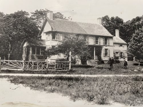
On July 14, 1877, the property was auctioned off on the steps of the Huntington House hotel.  Frederick G. Sammis was the high bidder.  He took possession in September and immediately began to improve the property.  Seven months later, The Long-Islander remarked, “It is astonishing what a difference . . . lumber and paint and a great deal of hard work will make in the looks of a neglected farm.”  Extolling the virtues of the site, the newspaper claimed that “The green fields, fringed with a wide strip of gravelly beach, dotted with beautiful trees, make this slope one of the finest spots in America.”  Sammis commissioned Elwood artist Edward Lange to paint the restored farmstead in 1880.  (A copy of the painting is posted at The Edward Lange Project)

Sammis did not hold the farm long.  In 1888, he entered an agreement to sell it to Charles S. Longhurst, who assigned the agreement to George Shaw.  Shaw was a partner in the firm of Aitken Sons & Co.  Other partners of the firm were the principals in the Huntington Company which had developed land to the west of the Selleck farm.  The old farmhouse was converted into the Huntington Bay Inn in time for the 1888 summer season (even though the property had not been formally conveyed yet).

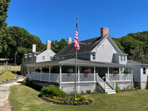
Uphill from the Inn, Shaw built a new house, which he named “The Oaks.”  The inn was removed in 1891 to open the view from Shaw’s mansion.  Shaw died in 1900, and the property was sold to John Cartledge, whose family had been summering at the Locust Lodge next door since 1893.

During World War I, the Cartledge family leased his property to the Yale Unit, a precursor to the Navy air corps comprised of students from Yale University.  The estate was converted into a military base with hangars, runways, a machine shop, a radio shed, and docks—although the airmen slept in the Cartledge mansion and had their meals prepared by a private chef.  During the training exercises, there were a few crashes and one tragedy when a sailor was hit by a propeller he had been cranking. The engine backfired and his arm was caught in the end of the prop knocking him into the spinning propeller. He died later that night. For more about the Yale Unit, see What Huntington Did in the Great War

John Cartledge, who was president of Brooklyn’s American Linoleum Company, had died in 1910.  The estate was inherited by his four children, who placed the property on the market, but it did not sell until 1924 when it was purchased by a syndicate of local investors who formed the Huntington Bay Hills, Inc.  The property was subdivided into quarter acre lots.  An eighteenth-century barn near the water, the Shaw Mansion, and the old water tower survive.  All other outbuildings made way for new homes.

Wincoma

In the early nineteenth century, the peninsula extending between Huntington Harbor and Huntington Bay was composed of three farms.  The stunning views from these properties were enjoyed by a series of wealthy New Yorkers. 

Louis M. Thurston owned what is now Lower Wincoma along the shore of Huntington Harbor.  He had been a broker on Wall Street.  He retired to Huntington at age 32 in 1836.  Here he farmed his harbor front land and became active in the affairs of St. John’s Episcopal Church.  He died in 1895, a week shy of his 91st birthday. 

Another tract of 16 acres along the Bay to the north of Thurston was purchased by physician Thomas Ward in 1851.  He was the son of a congressman and enjoyed a substantial inheritance; he also married into wealth.  Ward died in 1873. 

The third tract, which was east of Dr. Ward’s property, was owned by Captain Edward Stout, a wealthy, retired sea captain.

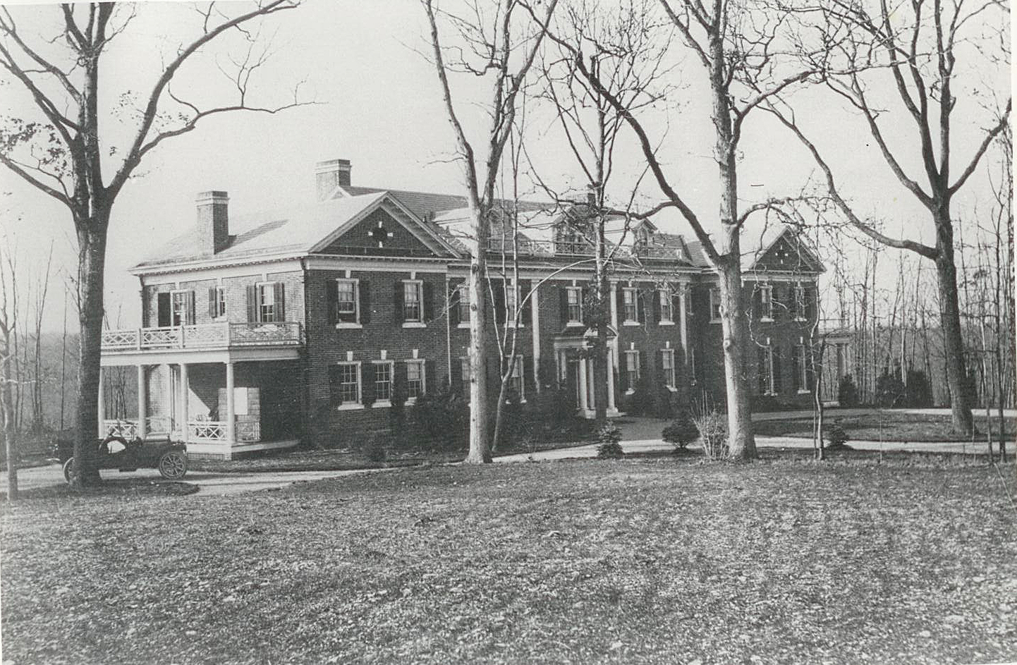
The Ward and Stout farms were purchased by Alfred Mulligan, who in 1865 built a magnificent mansion on a bluff overlooking the bay.  Mulligan was another Wall Street financier.  The view from the top of the cliff looking north over the bay and through to the shores of Connecticut is “one of the finest water views in the world,” according to The Brooklyn Eagle in 1899.[xxix]  Mulligan named his estate Cedarcliff.

In 1898, August and Nannie Heckscher purchased the Mulligan property and a year later the Thurston property as well.  The Heckschers were two of Huntington’s most generous philanthropists, donating the park and museum that bear their name among other things (see Mr. Heckscher’s Most Generous Gift To Huntington).  The Heckschers made improvements to the Mulligan mansion and rechristened the estate as Land Ends and later Wincoma.

Nannie Heckscher died in 1924.  Within a year, August Heckscher sold the estate to local real estate developer William E. Gormley, who divided it into 200 lots, most were a quarter acre; some up to 2 acres.  Gormley pledged to preserve the beauty of the property, especially its trees.

The mansion was purchased in 1926 by Henry R. Frost, a lawyer for the Long Island Lighting Company. He lived across the Sound in Greenwich and used the mansion as a summer home. Ten years later, during the Great Depression, the mansion was the subject of a foreclosure action. Frost and his family stayed at Wincoma for the summer of 1936 (the foreclosure was to be in May of that year). It is unclear when the foreclosure was finalized. But in November 1940, the mansion was being offered for sale by real estate broker Charles E. Sammis, Inc. Two months earlier, August Heckscher had returned to Wincoma. His friend and fellow real estate investor Charles Noyes hosted a 92nd birthday party for Heckscher at Noyes’ Wincoma house, two doors east of the mansion. Heckscher died the following April.  At the time of his death, his old mansion, now owned by his friend Noyes, was being demolished.

East Point

East Point enjoys one of the most spectacular settings in the Town of Huntington. 

In 1888, Dr. Daniel E. Kissam, a direct descendant of Dr. Daniel W. Kissam (whose 1795 house on Park Avenue is now a museum preserved by the Huntington Historical Society), purchased the peninsula and 10 acres of uplands from the Scudder family and built a rambling mansion

After Dr. Kissam died in December 1903, John Green, a 24-year-old millionaire owner of a Colorado mine, purchased the property. Green had the house remodeled and modernized and christened the house Point Siesta. Shortly after his wife’s death in 1911, Green sold the property to his brother-in-law James Elverson but continued to live there.  When Elverson died in January 1929, he was deeply in debt.  To pay the debts, the contents of the home were auctioned off, including hundreds of cases of wines and liquors bottled between 1840 and 1850.

In the 1960s, Arthur and Ruth Knutson owned and restored the house.  Later Gloria Smith, who owned the Yankee Peddler antiques shop, and her husband purchased the house and it was once again restored. After her husband’s death, Mrs. Smith made the house and property available for photo shoots.

The house was demolished in 2018 and a new home built in its place.  For more, see No More Second Chances

Rhinelander Estate

One of the earliest wealthy city dwellers to establish a country home in Huntington was John R. Rhinelander, a doctor from a wealthy New York family who fought cholera outbreaks in New York and Montreal.  Rhinelander built his magnificent mansion on a hill on East Neck between Huntington Bay and Huntington Harbor in the mid-1830s.  The home commanded spectacular views as well as attention from the surrounding community.

Dr. Rhinelander was active in Huntington affairs.  He died in 1857 at the age of 62.  His wife Julia died seven years later.  The house passed from one wealthy New Yorker to another, including John P. Kane, a partner in a large mason and building supply company in Manhattan.   The street on which the house sits was named for Kane.  Later, the house was owned by Frederick L. Upjohn of the pharmaceutical company and then by Thomas H. Roulston of the eponymous grocery store chain.

More recently, the house was owned by sculptor Joseph Mack and his wife, the painter Jean Mack.  In the early 1970s, after Mr. Mack suffered a life-threatening car accident, the couple started the Huntington Fine Arts Workshop in their home.  Five rooms in the basement were converted into sculpture studios and drawing and painting were taught in the ballroom.  In 1978, it became the Huntington School of Fine Arts and eventually moved to a former boathouse on Huntington Harbor.   For more, see High Lindens

Research for this post was conducted in partnership with Toby Kissam, who has written extensively on the history of Huntington Bay.


[i] The Long-Islander, June 1, 1877

[ii] The Long-Islander, March 26, 1880

[iii] The Long-Islander, April 4, 1891

[iv] The Long-Islander, June 29, 1895

[v] Suffolk County Clerk’s Office Deed Liber 261, page 59.  The land was held in his wife’s name.

[vi] The Long-Islander, April 7, 1882, July 7, 1882

[vii] New York Times, December 21, 1883 and February 11, 1884.

[viii] The Long-Islander, January 18, 1884

[ix] The Long-Islander, October 2, 1886

[x] Suffolk County Clerk’s Office Deed Liber 300, pages 483, 487, 492 and 498

[xi] Suffolk County Clerk’s Office Deed Liber 302, page 470

[xii] The Long-Islander, October 2, 1886

[xiii] The Long-Islander, February 5, 1887

[xiv] The Long-Islander, October 2, 1886

[xv] Suffolk County Clerk’s Office Map No. 66, filed January 18, 1888

[xvi] Suffolk County Clerk’s Office Map No. 454, filed July 15, 1897

[xvii] The Brooklyn Daily Eagle, February 13, 1888, page 2

[xviii] New York Times, September 4, 1915

[xix] Suffolk County Clerk’s Office Deed Liber 310, page 86

[xx] Suffolk County Clerk’s Office Deed Liber 56, page 120

[xxi] The Long-Islander, April 14, 1888

[xxii] South Side Signal, June 30, 1888

[xxiii] The Long-Islander, April 28, 1888

[xxiv] The Long-Islander, April 27, 1889

[xxv] The Long-Islander, March 10, 1888

[xxvi] Brooklyn Eagle, June 9, 1900

[xxvii] Brooklyn Eagle, June 9, 1900

[xxviii] The Long-Islander, September 26, 1891

[xxix] The Brooklyn Eagle, April 30, 1899, page 27

Read Full Post »

In 1929, Norman Thomas, one of the unsuccessful candidates in the presidential election the year before, moved to Cold Spring Harbor.  While a resident here, he ran for president five more times.  Thomas ran as as the Socialist party candidate in every election from 1928 to 1948. No one has ever run for president more often.

Thomas was born in Ohio in 1884.  After graduating from Princeton University, he followed his father’s footsteps and became a Presbyterian minister.  He was a conscientious objector during World War I and his pacifism led him to becoming a member of the Socialist Party of America.

He was an editor at The Nation magazine and ran unsuccessfully for several elected offices, including Governor of New York State and Mayor of New York City.  Although he and his family lived in New York City, in the 1920s they purchased a summer home in East Quogue.  In 1929, they sold the East End property to move closer to New York City.  They purchased five acres on Goose Hill Road.  Thomas’s wife Frances Violet Stewart came from a very wealthy family.  Her grandfather was John Aikman Stewart, who planned the organization of the United States Trust Company and served as Assistant Secretary of the Treasury under President Lincoln.  Her brother, W.A.W. Stewart, had married Emily de Forest, daughter of Robert W. de Forest who had a 225-acre estate stretching from the east side of Cold Spring Harbor to land east of Goose Hill Road.  Violet’s brother had a house overlooking the harbor.  Although having no architectural training, Violet designed the new 14 room U-shaped house, which still stands.

Violet raised cocker spaniels as part of her Blue Waters Kennels.  The family also had chickens and a cow, either rented or owned. 

Thomas was a socialist, but that didn’t stop him from enjoying the fruits of his wife’s wealth. He was a member of the exclusive Cold Spring Harbor Beach Club, where he would engage in political discussions with President Eisenhower’s Secretary of State John Foster Dulles and his brother Allen, director of the CIA. Although he seemed to rarely agree with the Dulles brothers, they maintained a cordial relationship.

Thomas regularly took the 8:15 train from Cold Spring Harbor to his job at the League for Industrial Democracy in Manhattan.  He also was a popular speaker across Long Island, speaking at churches, Rotary Club meetings and PTA meetings. 

However, he couldn’t translate his popularity as a public speaker into votes when he ran for president.  For example, in 1932 in Suffolk County, Herbert Hoover received 40,247 votes and Franklin Roosevelt 30,799 votes.  Thomas finished third with 1,365 votes, although well behind the major party candidates, he far outpaced the Communist Party candidate who received only 69 votes.

His popularity as a speaker increased in the 1960s when his speeches would draw thousands to hear his views on Civil Rights, the war in Vietnam, and a sane nuclear policy.

Thomas once said, “I am not the champion of lost causes, but the champion of causes not yet won.”  Indeed, although he never won any elected office, many of the causes he championed were enacted such as low-cost housing, slum clearance, the five day work week, unemployment insurance, social security, health insurance for the elderly, minimum wage laws, and abolition of children labor.  When he died at Hillaire Nursing Home in Huntington in 1968, he was hailed as the “Conscience of America.”

Read Full Post »

            What’s in a name?  When trying to promote development of an area, its name is important, especially if the name is not appealing.  Think Mosquito Cove (now Glen Cove) or Drowned Meadow (now Port Jefferson).  In Huntington, what had been known for over a century as Gallows Hill is now Fort Hill.

            The story begins during the American Revolution when Huntington was occupied by the British.  To guard their position in Huntington, the British built a fort at the eastern approach to the Town Common.  The fort stood at the intersection of today’s East Main Street and Maple Hill Road, at the point where East Main Street descends to the Park Avenue valley.  Traces of the fort could still be seen as late as a century after the war but are now lost.

            At the end of the war, the area near the fort was the site of a hanging.  Over the years, the identities of the men hanged and even which side they were on became confused.  In one telling, the two men were British soldiers who rode to their execution on their coffins.  The other version claims the men were American spies.

            In 1975, Huntington’s Bicentennial Committee went with the American spies version of the story and erected a historic marker on Huntington Bay Road.  The marker text: “Near this spot, two American Martyrs were hanged by the British during the Revolution.”  Why that particular spot was chosen to place the marker is not known.

            Recent research by David M. Griffin, who has written two books about the American Revolution on Long Island,* confirms that the Bicentennial Committee chose the wrong version.  The two condemned men were Isaac Algar and Nathaniel Parker, who fought for the British.  In August 1783, they were convicted of robbing and beating Platt Carll, who operated an inn on the north side of Jericho Turnpike between Manor and Warner Roads.  The convicted men were hanged on September 10, 1783 (the executioner was Provost Marshal William Cunningham, who was also present at Nathan Hale’s hanging seven years earlier).  Two and a half months later, the British evacuated from New York City.

The 1837 Coastal Survey Map

            For generations, the hill east of Park Avenue and north of East Main Street was known as Gallows Hill.  It was so labeled on the 1837 Coastal Survey map. Nineteenth century deeds described Maple Hill Road as the road to Gallows Hill.  The area was sparsely settled, so no one much minded the name.  But by the turn of the twentieth century, when more and more houses were built, it was decided a new name should be found.  Reference to the fort, even though it was a British fort, was preferable to a reference to the site of an execution.  Hence Gallows Hill became Fort Hill.

            To correct the record on September 23, 2024, a new historical marker was placed at the intersection of Maple Hill and Fort Hill Roads.


* Lost British Forts of Long Island (The History Press 2017) and Chronicles of the British Occupation of Long Island (The History Press 2023)

Read Full Post »

The Greenlawn School at 100

This has not been a good year for cornerstones.

Corner stones at the Laurel Avenue school in Northport and at the Broadway School in Greenlawn were chopped out to remove time capsules from 1924.

The contents of the 1924 time capsule at the Greenlawn School

That’s because 1924 was a year of growth and change.  That year saw the greatest number of new buildings in Long Island history up to that point.  The decade saw tremendous growth in Huntington.  The population of the Town increased by 84% from 1920 to 1930.

Among other things that happened in 1924, the village of Huntington Bay was incorporated and the post office started delivering mail directly to people’s homes in Huntington village!

Throughout the 1920s, farms and estates were being subdivided.  The Cartledge Estate became Bay Hills (1924); the August Heckscher estate became Wincoma (1925); The Fleet Farm became Huntington Beach (1926) and Knollwood (1924); and the old Kissam farm in Greenlawn became Cedarcroft (1926).

In Greenlawn, land south of the railroad tracks and east of Broadway (Gates & Grafton Streets) was subdivided in 1921 as Maple Park.  Two years later, the property of Edward Smith was subdivided.  The land on the west side of Broadway was subdivided into 45 lots, including a large lot for a new school.  A year later Smith’s property across the street was subdivided into 93 lots (Fenwick & Lawrence Streets).  The rest of his farm later became the high school.

This increased development required increasing the number of schools.  During the 1920s, new schools were built in Northport, Halesite, Huntington, Huntington Station, Cold Spring Harbor, Melville and Greenlawn.  The South Huntington and West Hills School district merged to better address the population boom.

Many of those schools have survived and been repurposed.  Adoptive re-use is critical to the survival of historic buildings.  The Greenlawn, later Broadway School, may have outlived its usefulness as a school, but it did not outlive its usefulness to the community. It has found its second act as the home of the Harborfields Library.  Today, the Greenlawn community celebrated not only the centennial of the Greenlawn School, but also the transformation of the building into a new library half a century ago.

Other second acts include the Northport High School on Laurel Avenue which became a school administrative center; the Main Street School in Cold Spring Harbor is now the DNA Learning Center; the Melville School is now the Melville branch of the Half Hollow Hills Library; Lincoln School in Huntington Station is now the Lincoln Farm apartments; and the Nathan Hale School in Halesite is now co-op apartments.

Harborfields Library, formerly the Broadway School, formerly the Greenlawn School

Read Full Post »

Older Posts »