Feeds:
Posts
Comments

Archive for the ‘Uncategorized’ Category

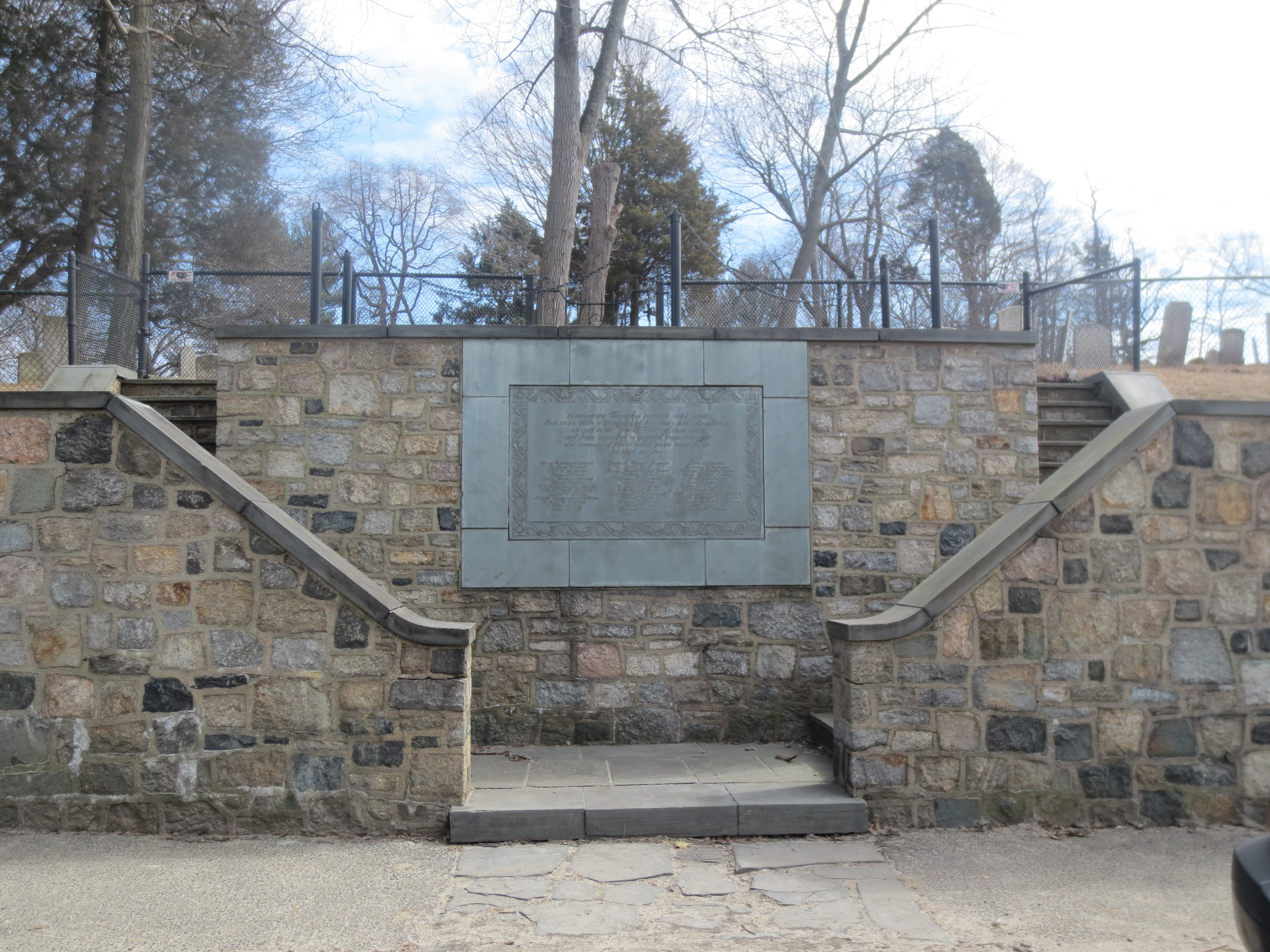
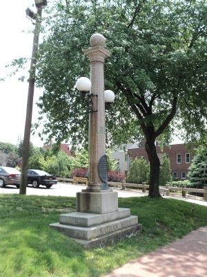
The first war memorial in Huntington, a list of 40 men who had died during the Civil War, contains familiar old Huntington names such as Sammis, Conklin, and Brush.  The second war memorial in Huntington, created in 1923 to commemorate the 39 Huntingtonians who had died during World War I, reflects Huntington’s changing ethnic make up.  In addition to the old Huntington names, the list includes names such as Algerio, Romano, Solomoff, Sickenberger, and Tivola.  More interesting is that the list includes a woman, Janet Ford.

Huntington's World War I Memorial on Main Street.  The Memorial also serves as an entrance to the Old Burying Ground where many of Huntington Revolutionary War veterans are buried.

Huntington’s World War I Memorial on Main Street. The Memorial also serves as an entrance to the Old Burying Ground where many of Huntington’s Revolutionary War veterans are buried.

Janet Ford was a graduate of the Huntington High School class of 1909.  She and her twin sister Eleanor graduated from Smith College four years later.  Not much is known about Janet Ford.  She and her sister were involved with the Huntington Red Cross chapter.  She was prominent enough to be included in a couple of New York Times columns about the social doings in Huntington.  Her father was employed as an expert accountant with Olney & Company in New York City.  He seems to have tried his hand with farming for a while on West Neck Road in the 1890s   The family eventually purchased the house at the southwest corner of Lawrence Hill Road and Carley Avenue.  They continued to spend time in Brooklyn as well.

When the United States entered World War I, there was a need for clerical workers.   The 1916 law authorizing the creation of Naval Reserve Force did not specify that yeomen needed to be men.  Eventually, 11,275 women joined the Naval Reserve Force as yeomen.  Eighteen women from Huntington served in the military; one was Janet Ford who served as a Navy Reserve yeoman in Manhattan.  She died in January 1919—two months after the Armistice was signed but while she was still in the service.  At first the cause of death was reported as pneumonia—the same disease that had taken her father and mother 10 days apart in November and December 1918.  A later report attributed all three deaths to influenza.  The 1918 flu pandemic claimed tens of millions of lives worldwide (estimates range from 3% to 6% of the worldwide population died from the flu).  In the United States, some 500,000 to 675,000 people died.  In fact, ten times more people died in the United States from the flu than from the war.  Half of the American servicemen who died during World War I died from the flu.

Even though she died far from the battlefield and after the Armistice, Janet Ford has always been counted among those Huntingtonians who gave their lives in the War to End All Wars.

Janet Ford is the second name in the second column.

Janet Ford is the second name in the middle column.

The title of this post may be subject to dispute.  After all, 18 Huntington women served in World War I.  Janet Ford is the only one to die during her service.  I hope I can be allowed a little latitude with the claim that she was the first woman veteran.

Read Full Post »

Gone and Almost Forgotten

George Hawxhurst was an elderly blind man who lived at the Industrial Home for the Blind from soon after it first opened in 1951 on the 32½-acre former Walter Jennings estate, Burrwood, in Lloyd Harbor, until he died at the age of 83 in 1976.  He had no known relatives, no money, and was destined to be buried in an unmarked grave in the paupers’ section of a local cemetery.  But the director of the Home and other staff members remembered that he was from an old Cold Spring Harbor family and that the family had a cemetery on the hill south of Cold Spring Harbor’s Main Street.

Neighbors of the cemetery objected.  There hadn’t been a burial in the cemetery in a quarter century, certainly not since the surrounding property had been subdivided and new homes built nearby in the late 1960s.  It would be unsettling for the children who now lived in the neighborhood.  The Town Board, which had control of the cemetery, overrode those objections and agreed that Mr. Hawxhurst should be buried with his family.

Who was his family?  It turns out that Mr. Hawxhurst descended from some of the earliest settlers of Cold Spring Harbor, many of whom, like the cemetery in which they are buried, are now forgotten.

One of the earliest settlers of Cold Spring Harbor was the Rudyard family.  The Rudyard homestead sat at the northwest corner of Main Street and Goose Hill Road and is said to date to the seventeenth century (it survived until 1901-02).  Who the earliest Rudyards in Cold Spring Harbor were has not been determined yet.  But a later member of the family, Captain John Rudyard, married Martha Conklin in 1741 in Huntington.  Their children were baptized in Oyster Bay, which is also where he owned land, so he may have lived there.  Their son John, however, was a carpenter in Cold Spring Harbor.  He married Catherine Doty, from another old Cold Spring Harbor family.

Martha C. Rudyard, one of Captain John Rudyard’s granddaughters, married Walter Jones in 1819.  This Jones, however, is not of the whaling company Jones family.  That family descended from Major Thomas Jones who settled in Oyster Bay by way of Rhode Island.  This Walter Jones was the great grandson of a Jones who came to Cold Spring Harbor directly from Wales.  There was a Thomas Jones who settled in Huntington in the seventeenth century.  A record of his widow conveying land to their children in 1681 can be found in the Huntington Town Records (Vol. 1, page 301).  The progenitor of the whaling family did not arrive on Long Island until 1695.

Martha and Walter Jones had at least six children.  Their son Walter Jackson Jones became a sea captain.  He was not involved in whaling, but with his brother Edmund sailed to Australia, China, and Japan as well as other foreign ports.  He also had oyster beds and provided a barrel of the shellfish to David Bennett Hill, the Governor of New York from 1885 to 1891.

Walter Jackson Jones never married.  He lived with is unmarried sister, Sarah Ann, in the old family house which was located where the Cold Spring Harbor municipal parking now is.  They were considered an eccentric couple.  The house was rundown: chickens would roost on the sills of the open windows.  Sarah Ann died in 1903.  Walter Jackson died in 1916.

A third child of Walter and Martha Jones was Jane who married Edward Seaman.  Edward served in the Civil War and later became a blacksmith in Cold Spring Harbor.  He was one of the founders of the J.C. Walters Post of the Grand Army of the Republic, a fraternal organization for Civil War veterans.  The Seamans lived in a house to the east of the Jones family homestead, where the post office is now located.   Edward Seaman died at age 58 in 1901.  They had one son and three daughters.  One daughter Jennie was born in 1871 and married at age 19.  She appears to have been widowed at a young age.  She and her son George lived with her mother. Jane Seaman died in 1923

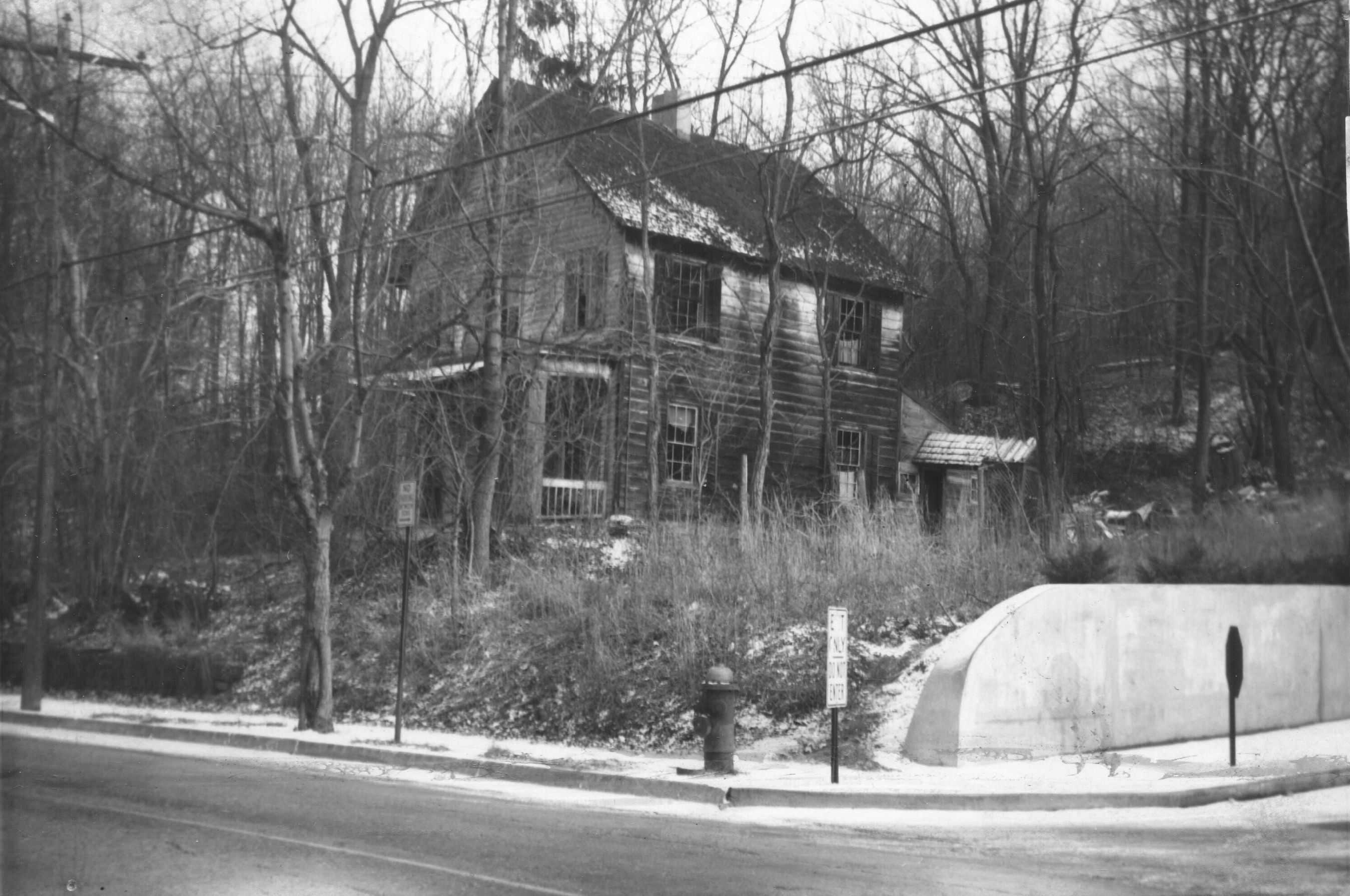
Jennie Hawxhurst reported that she was a dressmaker working from home for the 1920 census.  In 1930, she reported housework as her occupation.  In 1940, when she was 69, she reported no occupation.  The next year, it was reported that a real estate developer had purchased the 7½-acre estate of Jane Seaman, including the homestead with plans to subdivide it into half-acre lots.  However, when Jennie Hawxhurst died in 1953, she bequeathed the house to the Industrial Home for the Blind, where her son was then living.  The Home for the Blind owned the property in 1960.  She died at the Hillcrest Nursing Home in Northport.

The Seaman House, now the site of the Cold Spring Harbor Post Office

The Seaman House, now the site of the Cold Spring Harbor Post Office

Eventually, the old Jones homestead property was sold to others and then in 1960 it was taken by the Town of Huntington by eminent domain to build a much needed parking lot for Cold Spring Harbor.  The Seaman home was torn down to build the new post office building in 1962.

All these members of the Rudyard-Jones family are buried high up on the hill behind the family homestead.  An inventory of the cemetery was taken in 1962.  The cemetery was at that time already “in pretty sorry shape.”  Nonetheless, the recorder thought he got all the inscriptions.  He did note that next to Edward Seaman’s grave were two fieldstone markers which were decorated with stones and appeared to be recently added.  He reports, “I have heard tell of an old Mrs. Seaman being buried there recently.”

Fourteen years later, someone remembered well enough to secure George a place in the cemetery—the last of his family to be buried in the old family cemetery behind the long gone family homestead.

Read Full Post »

The Road Less Traveled By

This piece was updated on January 20, 2020 based on a newly discovered survey map.

Traveling east from Huntington towards Northport, about a mile past Park Avenue, a driver comes across Old Northport Road.  Until it was changed when the current bank building was constructed a few years ago, the intersection was a true fork in the road.  Continue on Route 25A, which curves to the left and you continue on a major artery passing a nursery, medical offices, and other commercial establishments.   Turn right down Old Northport Road, you travel down a narrow, unlined, quiet, residential street.  Judging by its name, the driver surmises that this was originally the road to Northport, which is, in fact, the case.  It seems obvious that a State highway engineer in Albany decided that this old road to Northport should be by-passed and a new better road built.

But why?  Old Northport Road is perhaps straighter than Route 25A and the descent from west to east is less steep (as is the climb from east to west).  It turns out the situation has nothing to do with Albany bureaucrats and everything to do with an early twentieth century wealthy landowner who wanted some privacy.

But first a detour into the nineteenth century.  Before the twentieth century, there were many fewer roads in Huntington.  Roads were laid out to connect points A and B.  The connection was direct, even if the roads did twist and turn to follow the topography.  Outside of villages, roads were usually nameless.  They were known for the two points on either end of the road.  A look at a road map shows that tradition continues further east, e.g. Patchogue-Mt. Sinai Road, and Miller Place-Yaphank Road.  Closer to home, there’s Syosset-Woodbury Road.  Alternatively, people referred to where the road went, which depended, of course, on which end you start from.  For example, what is now known as Greenlawn Road is known to old time Greenlawn residents as Huntington Road.

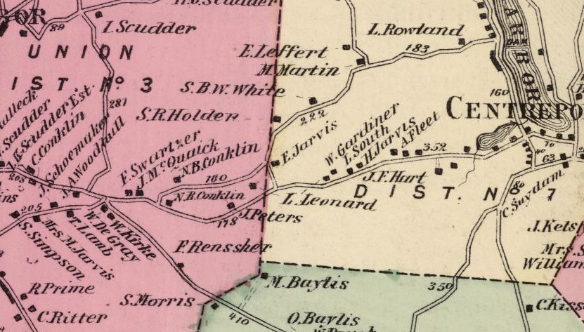
A section of the 1858 map of Huntington showing the road between Huntington and Northport, with a turn at the Jarvis house to the road to Centerport's grist mill.

A section of the 1858 map of Huntington showing the road between Huntington and Northport, with a turn at the Jarvis house to the road to Centerport’s grist mill. Click on the map to see an enlargement.

An 1858 map of Huntington shows a road leading from Huntington east to Centerport and then onto Northport (for the most part today’s 25A).  If you wanted to travel to the grist mill in Centerport, which was located on the west side of the harbor at Mill Dam Road, you could turn left at the bottom of the hill east of the intersection with today’s Washington Drive.  Perhaps because this route involved a climb up a steep hill, which was “very dangerous to travel,”[1]  a new road was built branching off of the road to Northport east of the fork with the road to Greenlawn (about where Woodruff Court is today).

It seems the new upper road became the preferred route to the east.  By 1883, the lower road had been so neglected that it was considered unfit for travel even though it “descends through the valley by an easy grade.”[2]  Using the upper road, which was in good condition, presented a problem for those traveling to the head of Centerport Harbor because of the steep slope down to the old road.  A proposal

A section of the 1873 map of Huntington showing the new road to Centerport's grist mill starting near the house of N.B. Conklin.

A section of the 1873 map of Huntington showing the new road to Centerport’s grist mill starting near the house of N.B. Conklin. Click on the map to see an enlargement.

was made to build a new road between the upper road and the all-but-abandoned lower road.  An eleven man jury met on December 15, 1883 at Merrill’s Hotel in Centerport to consider the proposal.[3]  Despite the fact that the new road would be straighter, shorter and less steep, the jury voted seven to four not to pursue the matter.  Opposition focused on the expense of putting in a new road, even though several neighboring property owners promised to contribute funds for the endeavor.  It was thought better to improve the old lower road.

Fast forward to 1907.  Roy A. Rainey, a millionaire sportsman from Cleveland, purchased Carmandale, the horse farm of Richard F. Carman—now the Crescent Club property.  Mr. Rainey quickly set about to improve his new property.    By 1908 hundreds of workers were busy remodeling the house and building a large addition.  The stables, which were too close to the house, were demolished and new stables were built further away.  Tennis courts were added (one grass, one clay).  A sprinkler system installed. A new well was driven.  In short, no expense was spared to create one of the finest estates on Long Island.[4]

There was one problem though.  The road to the Centerport mill ran too close to Mr. Rainey’s new house.  What’s a millionaire to do?  Ask to have the road relocated, of course.  In November 1908, Mr. Rainey asked the Town Board to consent to move the roadway several hundred feet to the south so that it would be the length of three football fields from his house.  On November 23, a special joint meeting of the Town Board and the Town Highway Commissioners met Mr. Rainey’s superintendent to review the proposed changes.  With some minor changes to civil engineer Frank Asbury’s map, the Town Board gave its consent to relocate the road just two days later.  Mr. Rainey, of course, agreed to bear the expense of the change.

The new road ran through the Jarvis farm, which Mr. Rainey purchased, passing between the Jarvis house and barn.

A section of the 1909 map ofHuntington showing the new road built by Roy Rainey.

A section of the 1909 map ofHuntington showing the new road built by Roy Rainey. Click on the map to see an enlargement.

The new route branched off from the road to Northport east of the turn for the road to the Centerport mill.  It then curved gently to the northeast for a short distance, then took an easterly course to the top of the hill where it turned northeast again to connect with the road to the mill.  A connection was built from the new road, down the hill, to meet up with the road to Northport.  We know this today as the intersection of 25A and Washington Drive.

The entrance to Mr. Rainey’s estate was at the southwest corner of his property.  The allee of trees that flanked Mr. Rainey’s driveway still stands and can be seen just west of the medical building at 205 East Main Street.

The new road was naturally the preferred route.  The old road to the south is identified on the 1941 Hagstrom street map as Lower Huntington Northport Road (who wants to take the low road?).  On the official 1946 Town Highway Map, it is identified by its current name, Old Northport Road.

Mr. Rainey’s 1908 road is, of course, now part of New York State Route 25A and has been since the State got involved with roads.  Route 25A never included Old Northport Road.  Historically, road building was a purely local concern.  Town government was responsible for laying out, maintaining and repairing roads.  This patchwork approach proved unsatisfactory by the end of the nineteenth century when bicycling was becoming ever more popular.  Bicyclist—or wheelmen, as they were called—started agitating for better roadways.  Their efforts were finally successful in 1898 when New York enacted the Good Roads Bill, also known as the “League of American Wheelmen Bill.”  Under the new law, the State would assume 50% of the expense of road construction, the County was responsible for 35% and the Town for the remaining 15%.  In addition to improving things for bicyclists, better roads benefitted farmers who could now get their produce to market more easily.

Suffolk County was quickly urged to seek its fair share of State funds.[5]  But it was not until the State raised $50 million through a bond issue in 1905 that large scale funding was available.  An additional $50 million was raised seven years later.

In Huntington State funding helped improve the Town’s two major east west thoroughfares (Jericho Turnpike and the then nameless northern road that is now known as 25A) and two roads to local train stations (Harbor Road connecting Cold Spring Harbor village with its train station, and New York Avenue).  At first dirt roads were improved by spreading gravel.  When gravel proved too difficult to maintain, macadam was used.  Macadam is a construction method rather than a material.  Developed by John Loudon McAdam in 1820, the method called for using small stones, all of the same size over a slightly convex surface.  Starting in the early twentieth century tar was used to coat the stones both to act as a binding agent and to keep dust down.  A surface so treated is tarmac, short for tar-bound macadam.  In the second decade of the twentieth century, concrete was used to form a long lasting durable road surface.  Asphalt was introduced in the 1920s.

What does any of that have to do with Old Northport Road?  When Huntington began to concrete 25A in 1920, the work started in Cold Spring Harbor and went as far as Rainey’s gate.  Later the work was continued from Rainey’s gate to Northport and on to King’s Park.  In other words, the improvements made on 25A were made on Mr. Rainey’s new road, not on the old road to Northport.  Therefore, from the very beginning, Route 25A incorporated the road Mr. Rainey built and not the historic road to Northport.

This explanation may have been as winding as an old country lane.  But I hope we have reached our destination: an understanding of why one segment of what had been the main route between Huntington and Northport is now the road less traveled by.


[1] The Long-Islander, December 21, 1883

[2] The Long-Islander, September 7, 1883

[3] The Long-Islander, December 14, 1883

[4] The Long-Islander, April 24, 1908

[5] The Long-Islander, February 18, 1899

Read Full Post »

Happy Constitution Day!

That’s not a greeting often heard even though Congress officially designated September 17 as Constitution Day in 2004.  Before then, September 17 was known as Citizenship Day, the designation given to that date by Congress in 1952.  The holiday’s origins are even earlier.  Citizenship Day had been known as “I am an American Day” and was celebrated on the third Sunday in May pursuant to an act of Congress signed in 1940.

But how and when did “I am an American Day” start?  In a letter to the Editor of Broadcasting magazine (June 28, 1948), Martin Pine claimed his brother, Arthur Pine, gets the credit.  According to Mr. Pine, during the New York World Fair, which took place in 1939-40, songwriters brought his brother a song called “I am an American.”  Arthur Pine, who was handling publicity for bandleader Gray Gordon, convinced the bandleader to use the song on the radio and later Arthur Pine arranged for “I am an American Day” at the World’s Fair.  The celebration was picked up by the Hearst newspapers and came to the attention of President Franklin Roosevelt who signed the legislation officially recognizing the day.

Is that really the beginning of the observation?  Not if you consult a granite monument in front of historic house on New York Avenue in South Huntington.  According to the monument, “I am an American Day” was first held in Huntington in May 1938—a year before the World’s Fair.

1947 Monument

1947 Monument

At that time the home was owned by Mr. & Mrs. Paul Seghers and was known as Sunnyhill Farm.  Mrs. Seghers was from Poland.  Her first husband was a professor of Natural Sciences at the University of Petrograd.  According to a 1957 account, she lost her husband, her only child and her fortune at the hands of the communists before fleeing to America.  To show her appreciation for her new country and its ideals, she decided to devout herself to the propagation of Americanism and an appreciation for the country’s founding documents—the Declaration of Independence and the Constitution.  She established The Helios Foundation, which was dedicated to “cultivating American ideals and better understanding among mankind.”

In Huntington the third Sunday continued to be celebrated as “I am an American Day” despite the change to Citizenship Day made by Congress in 1952.

Read Full Post »

Squadron Hill is a 1960 subdivision located about a half mile west of Huntington village.  Most of its inhabitants have been led to believe that the property was used by Theodore Roosevelt to train his Rough Riders prior to fighting in Cuba during the Spanish American war in 1898.  One of the streets in the development is even named Rough Rider Court.  There was once a sign on Main Street welcoming visitors to Huntington, “Home of the Rough Riders.”  In fact, some residents talked about Rough Riders coming back after the houses had been built to view their old training grounds.  But if anyone had stopped to do the math, they would have realized that a veteran of the Spanish American War would have been quite old by the time the houses were built.

The story isn’t true.

In 1898, Theodore Roosevelt was living in Washington, D.C.  After receiving permission to form an all-volunteer cavalry force to fight in the Spanish American War, he went to San Antonio, Texas where the First Volunteer Cavalry trained and was given the nickname the Rough Riders.  The closest Roosevelt’s Rough Riders actually came to Squadron Hill was Camp Wikoff in Montauk, where the unit camped after their tour of duty in Cuba.  Prior to the publicity surrounding Roosevelt’s unit, the term “rough rider” appears to have been a generic reference to cavalry men.

In later years, Theodore Roosevelt did visit Squadron Hill, but in 1898 the land that now comprises Squadron Hill was being farmed by Alfred Rogers, a member of a large and prominent family in the Cold Spring Harbor area (in fact, Turkey Lane was once known as Rogers Avenue).  One hundred years ago Squadron Hill comprised the bulk of the Rogers’ 100 acre homestead, which was made up of two parcels—twenty acres north of Lawrence Hill Road and 82.5 acres south of Lawrence Hill Road, bounded on the west by Peabody Road, on the south by Saw Mill Road and Woodbury Road, and on the east by the land of various neighbors.  The Rogers’ house, a five bay 2.5-story gable roofed house, still stands at 97 Lawrence Hill Road.  The north wing of the house is estimated to have been built in about 1820 and the main house in about 1860.  The house has recently been renovated and enlarged by its present owner.

Alfred Rogers had inherited the farm from his father, Moses Rogers. Moses Rogers’ father, Zebulon Rogers, was a Revolutionary War veteran.  Although the early records are unclear, it appears that Zebulon Rogers owned the homestead when he died intestate in 1820.  An inventory of Zebulon Rogers’ personal property includes among other things, a house (valued at $60), four cows and six sheep.  Moses Rogers appears to have acquired the homestead from his siblings following their father’s death.

Known around town as “Uncle Moses,” he was born on April 25, 1784 in the old homestead.  Moses Rogers, a wealthy but unpretentious man, was a farmer his whole life, working the farm up to within a few months of his death in 1878, just eleven days shy of his 94th birthday.  The Rogers farm was diversified.  According to the 1860 agricultural census, Rogers grew a variety of crops:  wheat, rye, oats, Indian corn, Irish potatoes, barley buckwheat and hay.  They also had 5 milch cows (producing 500 pounds of butter), 12 pigs and 50 sheep (producing 150 pounds of wool).   In addition to farming, Moses Rogers owned several ships, including at the time of his death “an interest in almost every coal schooner that went out of Cold Spring and many of the Northport vessels.”  He also served as the town’s Overseer of the Poor for several years.  On Moses’ death, the homestead passed to his son Alfred, who was born in 1820.

At his death 81 years later, Alfred was eulogized as one of Huntington’s “oldest and most respected residents.”   Two months before his death, Alfred conveyed the farm to his son Franklin P. Rogers for one dollar, reserving a life estate for Alfred and his wife, Phebe Ann.

Frank Rogers was the last of his family to farm the homestead.  In 1905 Frank, his wife Esther, and Frank’s mother Phebe Ann sold the 82.5-acre parcel south of Lawrence Hill Road to a Brooklyn-based National Guard cavalry unit for $15,000 (including two mortgage notes, each in the amount of $5,500; one payable to Frank, the other to Esther).

Frank apparently continued to farm the twenty acres of the homestead north of Lawrence Hill Road until about 1914 when he sold the remaining parcel to Jerome A. Suydam and moved to a house on Woolsey Avenue in Huntington.      Frank and Esther had no children.

TROOP C

The cavalry unit that purchased the farm was formed in 1895 after several unsuccessful efforts to organize a cavalry troop in Brooklyn.  But the 1895 trolley strike in Brooklyn, during which Troop A of neighboring New York City was called in to help control, “demonstrated the value of cavalry for State service, and the need of an organization in Brooklyn.”

In the spring of 1895, authorization was given by the Adjutant-General of the New York National Guard to organize a troop.  On August 27, 1895, the North Portland Avenue Armory in Brooklyn was converted from infantry use to cavalry use.  On December 16, 1895, Troop C was mustered into the service of the National Guard (the letter B was claimed by a troop forming in upstate Geneseo at about the same time).

The troop was composed of well-to-do gentlemen of Brooklyn—businessmen, lawyers, doctors and college students.  By 1898 the troop achieved full membership and when war was declared against Spain, the troop volunteered as a body to join the fight.

In May 1898, the troop trained for three weeks at Camp Black on the Hempstead plains, after which the troop was mustered into federal service as Troop C of the N.Y. Volunteer Cavalry and eventually saw combat duty in Puerto Rico.

By 1909, Troop C had a membership of 150 and a waiting list twice as long.  The troop was expanded into a squadron with the same letter designation under the command of Major Charles I. DeBevoise.  Following reorganizations and re-namings understandable only to the military mind, the Fourth Platoon of Troop C became Troop 6 of Squadron C and eventually Troop K of the First New York Cavalry.

SQUADRON C FARM

Membership in this National Guard unit was not strictly a military matter; There were social and recreational aspects as well.  In 1905, a few of the wealthier members of the unit formed Troop C Armory Auxiliary, Inc. and purchased the 82.5 acres of the Rogers homestead south of Lawrence Hill Road.  The farm was to be used as a riding club for members of the troop.  The troop members also opened a clubhouse across the street from the armory in Brooklyn.  The clubhouse was operated by Squadron C Cavalry Club of Brooklyn, Inc., which was formed in 1915 and was open to members of Troop C of the N.Y. Volunteers, Troop C and Squadron C of the N.Y. National Guard, and the First Cavalry of the N.Y. National Guard who were quartered in Brooklyn.

Squadron C's Sleeping Cabins:  One survives today

Squadron C’s Sleeping Cabins: One survives today

The purpose of the club was “to provide a Club House [in Brooklyn] for their meetings and social intercourse; and to promote their interest in the Cavalry service of the National Guard of the State of New York and preserve the traditions of their own past service.”

In 1929, the club’s charter was amended to include among its purposes the encouragement of recruits to join the cavalry service.  In 1921, members of the squadron formed Squadron C Farm Inc. to manage the squadron’s stock farm in Huntington.  The specific purposes of the corporation were “to breed and raise horses for military purposes and otherwise, and to keep, rent and deal in same, to sell its produce, to own the farm buildings and equipment thereon … and to have the farm used as a place of recreation, athletic exercise and military drills.”

The unit had always raised its own horses because, while the State of New York supplied saddles, bridles and other equipment, it did not provided horses.  The unit would buy and breed horses and sell those they didn’t want on the open market.  They started with only a handful of horses and by 1912 had 300 of the finest quality military horses in the country.  Representatives from the War Department came out to the Farm to inspect the horses and were impressed with their quality.


THE GREAT WAR

The Brooklyn men were mobilized in July 1916 for federal service on the Mexican border chasing Mexican revolutionary Poncho Villa after his attack on Columbus, New Mexico.  In March 1917, the unit was mustered out of federal service but remained as a National Guard unit.  Just four months later, the New York National Guard was called into service to fight in World War I.  By military alchemy, Troop K was transformed into Company A of the 106th Machine Gun Battalion and the cavalrymen were accordingly relieved of their horses.

While the Brooklyn men were preparing to fight in France, where they would be credited with helping to break the Hindenburg Line, the men of the Huntington Rifle Club met to consider forming a Home Defense Reserve, which would train at Squadron C Farm.

At the initial meeting on July 13, 1917 at the Masonic Hall, 24 men enlisted in a Home Defense League.  Sixty more joined at a meeting the next night.  Two volunteers had to be rejected from membership—Eugene Johnson, a veteran of the Civil War, was ten years over the age limit; and Thomas Miranda, an Italian immigrant, was not yet fully naturalized.

The League started drilling eleven days after its inception and made its first public appearance in the Town’s Labor Day parade that year.  A similar unit in Cold Spring Harbor mustered in as a Home Defense Corps under regulations promulgated by the Adjutant General of the National Guard.  The Huntington group intended to do the same, but Major C.S. DeBevoise of Squadron C recommended that they join the National Guard whose ranks had been depleted when its members were federalized.

The National Guard was now unable to perform its traditional duties, such as riot control or suppression of an uprising by the alien population (considered a real threat at the time).  Moreover, a trained force was needed as a back-up to federal forces engaged in Europe.  On September 26, 1917, 52 members of the Huntington group agreed to take the State’s oath of enlistment and became members of Troop K of Squadron C.  Troop K trained through the winter in Huntington village and along its highways.  The following June, horses arrived from the Armory in Brooklyn and cavalry training commenced at the squadron’s farm.  Huntington residents drove out to Squadron C Farm to observe the military preparations.

The local troop reached its greatest number in January 1918 when it had 64 members. The number dwindled as some joined the federal army and others dropped out as their enlistments expired and the Armistice obviated the need for the Guard.  After the war, the National Guard was reorganized and small, isolated units were transferred to armories throughout the state.  On October 30, 1919, Troop K was transferred to Brooklyn. The remaining 18 Huntington members were given Honorable Discharges on February 9, 1920.

A PART OF THE HUNTINGTON COMMUNITY

Despite being based in Brooklyn, the troop became a part of the Huntington community.  Huntington was becoming a popular summer resort for New York’s wealthy.  In 1909, The New York Times noted, ”with the arrival of Squadron C of Brooklyn at its summer camp here there will be a whirl of activity.  This crack military organization makes things hum when it comes here for its summer maneuvers.  Its presence also adds an element of activity to the general air of the resort.”

Squadron C donated a trophy awarded to the winner of the annual bobsled race held on Main Street (from the top of Cold Spring Hill to as far as New York Avenue) between 1907 and 1920.  In 1909, the Troop escorted the first car on the inaugural run of the Huntington-Amityville trolley line and participated in Fourth of July parades.  The troop also entertained local residents with monthly exhibitions and polo matches.  According to legend, the cavalry was once called to quell a riot caused by an armed robbery.  However, they also annoyed local merchants by galloping down Main Street.

It was during the early years of the Farm that Theodore Roosevelt was a visitor.  In August 1908 when he was President, Roosevelt rode an automobile over from his home in Oyster Bay to inspect the troops.  Later visits were unofficial.  According to William Stefurak, who joined the Squadron in 1936, older members mentioned Roosevelt’s visits.  The President would “sit on the porch with the guys and swap lies.”  The memories, records and photographs of some of the members, such as Bill Stefurak, provide a fuller description of the Farm and its activities from the late 1930s onward.

The entrance to the Farm was on Lawrence Hill Road, more or less where Donovan Drive now begins. A sign near the main gate read, “Ladies will please not pass this point.”  Ladies were thus deprived of visiting the race track to the right of the entrance road.  To the left was a practice polo field, followed by two clay tennis courts behind which stood two cement handball courts (which stood until recently in the yard of one of the houses on Donovan Drive).  South of the tennis courts were twenty bungalows, each equipped with six spring beds and with shutters on all sides that could be opened in the warmer weather.
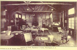
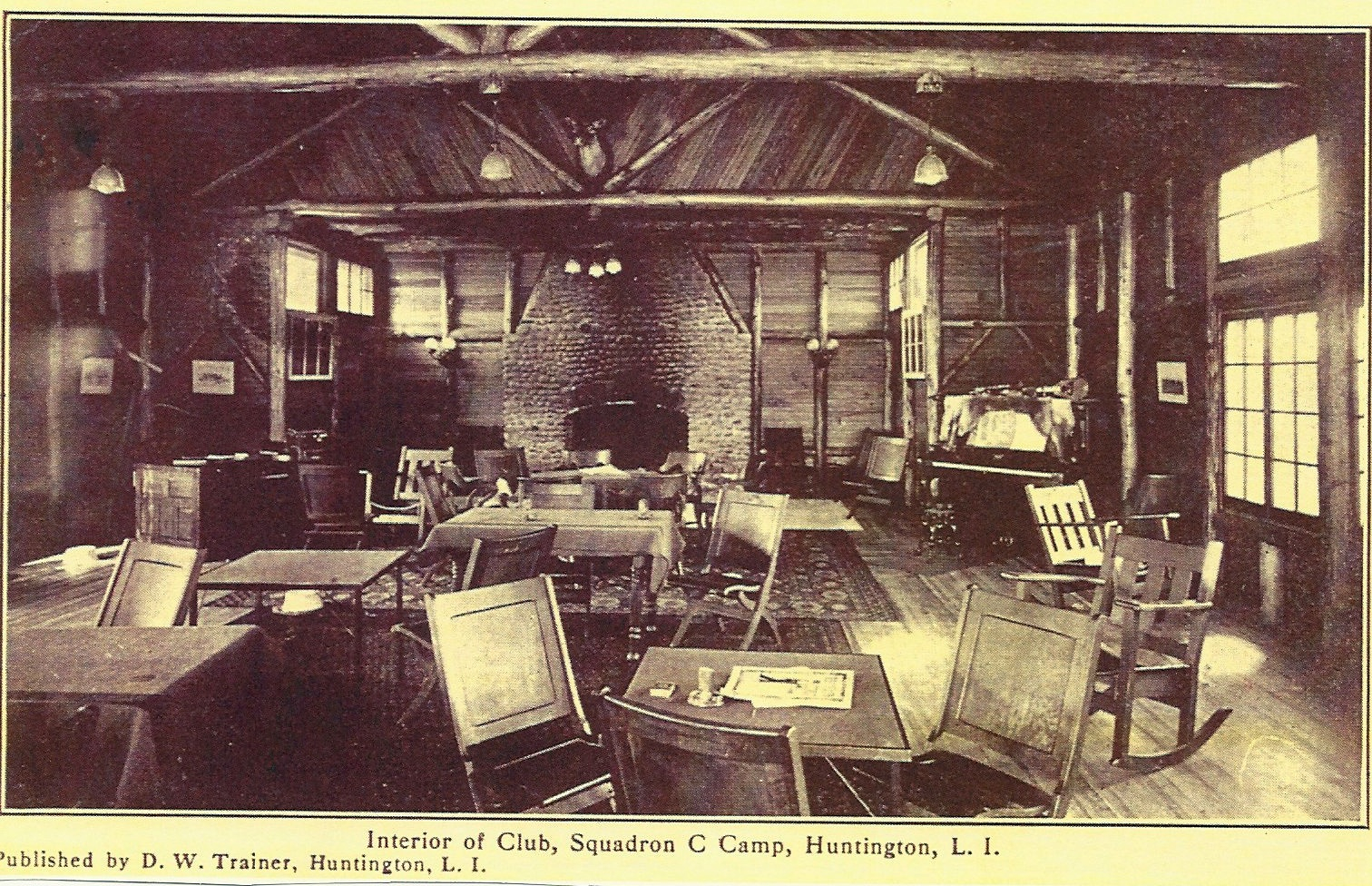
The Club House is gone, but the fireplace still stands

The Club House is gone, but the fireplace still stands

To the east of the bungalows stood the mess hall (which could accommodate 125 to 150 at a sitting) and the clubhouse. The stone fireplace for the clubhouse still stands in the yard of a house on Squadron Court.  The mess hall, which was at a right angle to the club house, stood more or less where Squadron Court is now.  Further south was the wash house or locker room and a water tower.

The road ended in a T intersection.  To the left (east) it led behind the wash house to a parking area.  To the right the road led to the stable complex which stood approximately where Donovan Drive and Rough Riders Court now intersect and consisted of a shed, four stables, a barn, a water tower and pump house.

To the south and west of the stables was the polo field.  The Farm was open from early July to early September.  From September to June the men trained once a week in the armory in Brooklyn.  During the summer months, the horses were stabled at the Farm.  Although the Farm was established for the benefit of the men, the horses seemed to be rejuvenated after two months in the fields eating fresh grass.

Some members lived at the Farm all summer commuting to their jobs in the city.  Most, however, came out just for the weekend.  Although there was no charge to stay in the bungalows, the men were charged for breakfast (50¢) and dinner ($1) whether they ate on the Farm or not.  Lunch was 75¢.  Active members of the squadron, who paid $4.25 a month in dues, were charged 50¢ to ride a horse at the farm.  Veteran members, who paid annual dues of $9, paid $1 to ride a horse.  The dues paid for the upkeep of both the Brooklyn clubhouse and the Farm.

The Mess Hall

The Mess Hall

In the summer, the cooks from the clubhouse and the staff from the armory would come out to tend the horses and maintain the farm.  Members would arrive by car or take the train to Cold Spring Harbor, where they would be met by the farm bus.  Although the farm had tennis courts, handball courts and baseball diamonds, most men spent their time on horseback.  They could ride a trail with jumps through the hilly wooded section of the property along Peabody Road.  This area was known as the “Russian ride.”  The origins of that name are lost, explained Stefurak:  “There was an Italian jump on it.  Figure that out.”

There was also a sabre course in the southwest corner of the Farm where Peabody and Saw Mill Roads intersect.  Some members would organize races on the racetrack near the entrance to the Farm.  The track, which was in a hilly area, “was all up and down, the damnest thing you’d ever want to ride on,” remembers Stefurak.

The men would wear racing silks and odds would be placed, but it was all done for fun.  “You make a couple of bucks here, lose a couple of bucks.  And if you made it, you’d buy beer anyway,” explains William Hurley, who joined the squadron in 1938.

Members would also ride out through the surrounding countryside.  A brochure for the 1937 season boasts of “the diversity of scene found in this charming wooded, rolling country. . . .   The region abounds in bridle paths, so that little or no riding need be done on main highways.”  Destinations included the Otto Kahn estate, Eagle Dock Beach in Cold Spring Harbor, and a German beer garden in Melville.  “We always went up to Melville,” recalls Bill Hurley.  “At that time, the property around the Farm was farms; potato farms and so forth.  You could ride right from the Farm itself right to Melville.”

Polo matches between the squadron’s team and teams from the U S. Army and local polo clubs were held every Sunday.  Spectators would enter through the white gate, which still stands, on Woodbury Road just east of Saw Mill Road.  The members, most of whom were single, rode hard during the day and raised hell at night.

Some went into town on dates with the nurses from Huntington Hospital, but most spent their evenings on the Farm.  While the Farm was run like an exclusive country club, Hurley says, “the men themselves came from all walks of life.  You had attorneys and you had draftsmen and you had bus drivers.  You name it.

“We lived like millionaires.  We were the working class of Brooklyn and we lived very well,” adds Stefurak.

But on the eve of World War II, the Farm was once again used for military training.  Members enlisted in the federal service for one year from January 1941 to January 1942. That one year enlistment was soon extended for the duration of the war.

The Farm fell into disuse and was leased to a local farmer to graze his cows.  Reportedly the turf at the Farm was so good that during the war some of the sod was transplanted to Ebbets Field in Brooklyn, which was three blocks from the Squadron’s armory.  To help commercial farmers work their fields in the face of labor shortages during the war federal and state agricultural agencies proposed using the Farm to house 250 Bahamans, who would work on local farms.  The Huntington Town Board denied the request because it would violate local zoning laws.

World War II also saw the demise of the cavalry.  Horse fighting was deemed incompatible with modern warfare and both the U.S. Army and the New York National Guard abolished their cavalry units.  During the war, there were no active members paying their $50 a year in dues, so “the Board of Governors had to make a choice between the Farm and the clubhouse. Most felt under the circumstances it was better to hold on to the Farm and to sell the clubhouse, which they did,” explains Hurley.

While the men were training at Fort Devens in April 1942, club officials came up and told them to sign their rights to the Farm over to Squadron C Cavalry Club.  In May 1942, Troop C Armory Auxiliary conveyed the farm to the Squadron C Cavalry Club of Brooklyn, Inc. for a nominal sum.  In August 1942, the club’s charter was again amended,

this time to allow the club to hold real property and thus legitimize the purchase of the Farm.  To be sure of good title, the club also received a quitclaim deed from Squadron C Farm, Inc., which had been managing the property for over twenty years.

AFTER WORLD WAR II

In the summer of 1946, after returning from service in the Pacific theatre, Stefurak took his wife Ruth out to see the Farm.  They found the buildings intact but surrounded by four-foot high grass.  Some of the grass was trampled down in a path leading to one of the bungalows.  Inside, Stefurak found three other members of the cavalry club, John Delapina, Arty Campbell and Bill Sloan.  Stefurak asked, “Why don’t we get some of the guys together and get the farm going again?”

And that’s what they did.

They cut the grass, painted the buildings, rebuilt the tennis courts, planted flowers around the clubhouse and maintained the pump house, which according to Stefurak, produced “the sweetest water you ever tasted.”

Still missing were horses.  Since the cavalry unit was disbanded, there were no horses to bring out from Brooklyn.  Squadron A, in Manhattan, did manage to hold onto its horses.  Squadron A loaned the horses for the summer in 1947, but someone let them loose and the privilege was not extended the following year.   Instead, the club entered into a month-to-month lease with John and Francis Rice to operate a horse farm on the site.   In addition to receiving rent from the Rice brothers to pay the property taxes, club members could ride the horses for $2.  Weekends at the Farm were now more do-it-yourself.  There was no staff to cook meals and no set schedule of fees.  Instead those who came out put up five dollars and shopping details were organized.  The shoppers would drive into Huntington village, buy some steaks at Berger’s Butcher Shop on New Street and then stop at Finnegan’s for a drink before driving back up to the Farm.  The steaks, or sometimes lobsters, were barbequed on Saturday night.  “At night we got dolled up and we went out,” remembers Stefurak.

Enjoying the Club House after the war

Enjoying the Club House after the war

In addition to tennis, the men, and now their wives as well, would continue to ride horses out into the countryside.  The Melville beer garden was still a popular destination.  They would also visit the Marshall Field estate to swim in the Long Island Sound (the club members were admitted to the still private estate by the stable hands who knew them from the pre-war period).

Sunday dinner was at Ma Glynn’s on East Main Street or Rothman’s in East Norwich.

Bill and Ruth Stefurak were post-war regulars at the Farm.  “It was a great weekend.  I’d come out here. I’d ride, play tennis, swim, have a good drink, good eatin’.  What more could you ask for?  We had everything for nothing.”  Immediately after the war, 50 to 60 members would regularly gather at the Farm for picnics.  But as time went on and families grew, the number dwindled to about twenty, then to only 10 or 12.

The Rice brothers converted the polo field into a show ring and gave riding lessons and organized horse shows there.  In 1949, the Irish American Club held its first Irish Field Day at the Farm.  Four years later, tens of thousands of visitors took part in the Town’s three day Tercentenary celebration at the Farm.

Starting in 1950, members of the New York Greyhound Owners and Breeders Association transformed the old saber course into a dog racetrack complete with starting gates and an electric rabbit.  Non-betting races were held every Sunday until 1966.

DEVELOPMENT

Almost as soon as the Farm was up and running again after the war, efforts to sell the land began.   Despite the desire of World War I era veterans to sell the Farm, the younger members kept the Farm going for 15 years.  Eventually, club membership, which due to charter restrictions could not be replenished, was dwindling due to deaths.  Furthermore, the club stopped accepting new members from among those who were eligible to join.  Some members quit the club because of this change in policy.  The older members argued that the purpose of the club—to encourage enlistment in the cavalry—was impossible because the cavalry no longer existed.  Moreover, they argued, why keep the place going for the select few “who raised hell” on the weekends.  The younger members, not all of whom used the Farm regularly, disagreed.  They claim that the old-timers got greedy.

“They saw a good plot of land on which they could build and make some money on it.  And they wanted to take advantage of it,” explains Stefurak, who vehemently opposed the sale.  Stefurak didn’t see it as simply a question of the club maintaining a playground for just a few members.  He asked, “What are you going to get out of it?  A few hundred dollars?   Doesn’t it make more sense to donate it to the Town of Huntington and establish an open preserve and maybe have horses there so your grandchildren can see it?  Wouldn’t that be worth a couple of hundred dollars a piece to you?”

Members opposed to the development of the Farm suggested donating the land to the Huntington School District, which was looking for a site for a new high school, or to the boy scouts.  In fact, the Huntington school district in 1955 had a referendum to approve the purchase of 54 acres of the Farm to build a new high school to replace the crowded Main Street school (now Huntington Town Hall).  The voters rejected the proposal by a vote of 1162 to 848.  The new high school was built just a few years later on Oakwood Road.  New York State approached the club about acquiring some of the land for an armory, but was refused.  Another suggestion to re-route the proposed Bethpage State Parkway extension to Caumsett State Park from the shores of Cold Spring Harbor through the farm and Huntington Country Club was also not pursued.

Bill Hurley, who did not visit the Farm much after the war, felt “there was an awful lot of skullduggery going.”  He believed that many of those pushing the sale were also part of the group that sought to purchase the property.  “They didn’t own the property.  They didn’t put a penny down for the purchase price,” Hurley complained.  Moreover, the club could afford to keep the Farm.  In 1960, the annual real estate tax, insurance and maintenance costs for the property amounted to about $4,000.  Dues from 144 members (there were also 22 life members who did not pay dues) netted the club $1,300 and the Rice brothers lease brought in $3,480 a year.

However, if the Rice brothers, who had a month-to-month tenancy, decided to vacate, the club would have an annual deficit of about $2,700, an amount that could quickly deplete the club’s liquid assets of $10,500.  The club’s Board of Governors, which considered the land underutilized and thought the club could benefit more from the money than from continued use of the land, approved the sale to Rough Riders Farm, Inc., the president of which was George R. Tollefsen, a member of the cavalry club.  The purchase price was $290,000.

Although not required, the sale was also voted upon by the membership at large which also approved of the sale by a vote of 79 to 33. Considerably more than the handful of members who used the farm regularly voted against the sale. The opponents of the sale were extremely bitter. “It kind of broke our hearts,” Stefurak recalls.

Proceeds of the sale were divided among the club members, each receiving $1,800 (about $13,500 in 2012 dollars) in two or three installments as the mortgages were paid off.  A fund was set up to establish an endowment to be given to the Brooklyn Historical Society to preserve materials and artifacts that the club had donated to the society.  Each member was asked to give $100.  Hurley gladly gave to the fund: “I felt this is for a good cause.  It’s good for the artifacts which I was part of for so many years and I’m getting the eighteen hundred dollars gratis, so why not give a hundred to this fund.”  The members raised $10,000 which “at that time seemed a tidy sum.”

In 1962, a proposal to develop the property with luxury apartments went nowhere.  The clubhouse burned to the ground in a spectacular fire in October 1962 with flames reaching 50 feet in the air.  Rough Riders Farm, Inc filed a subdivision map with the county on June 4, 1964.  The map depicted three new streets.  The names of two of the streets recall the land’s cavalry past—Rough Riders Court and Squadron Court.  The principal street, Donovan Drive, was named after Rough Riders Farm, Inc.’s lawyer and principal, James B. Donovan.  Donovan, a partner in the firm of Watters and Donovan, served as general counsel to the Office of Strategic Services during World War II and as an associate prosecutor at the principal Nuremberg War Trial.  He gained notoriety in 1957 when he was appointed to represent accused Soviet spy Rudolf Ivanovich Abel, who was exchanged for U-2 pilot Francis Gary Powers.  He later negotiated the ransom of prisoners taken by Cuba in the failed Bay of Pigs invasion.

In December 1964 Rough Riders Farm, Inc. conveyed the property to Laurel Estates Corp., which built and sold houses of Squadron Hill.  Later that month, the last horse show was held at the Farm.

The first residents of Squadron Hill’s new incarnation arrived in 1966.  Today, Squadron Hill consists of 40 houses on 1.5 to 2 acre lots, three ground water recharge basins and a 3.9-acre town park.  Almost half a century of suburban landscaping and natural forest succession mask the area’s prior use as a farm, military training camp and summer retreat for the rough riders of Brooklyn’ Squadron C.  All that remains are the old stone fireplace, an old barn, one of the sleeping bungalows, and the white gate on Woodbury Road.

Read Full Post »

While the welfare state is considered a modern development, caring for the less fortunate among us is not a new concern.  And while today it is considered a federal and state responsibility, until the last quarter of the nineteenth century it was a local concern.  In Huntington, the first record of aid to the poor is dated 1729.  The Town continued to care for the poor until 1872, when the responsibility was passed onto the County.

Caring for the less fortunate is an ancient practice.  Ancient Babylonian, Greek, and Roman societies imposed a duty to provide for the poor.  The Bible also imposes such an obligation.  The Old Testament speaks of the duty to aid the sick, the old, the handicapped and the poor.  The injunction is repeated in the gospel of Matthew:  “whatever you did for one of these least brothers of mine, you did for me.”

In medieval England, the responsibility to provide for the poor fell to the church through its extensive system of monasteries.  But with the abolishment of monasteries under Henry VIII, the obligation fell to secular authorities at first supported by voluntary contributions and then after 1572 by a compulsory assessment (i.e. taxes).  Further amendments led to the enactment of the Elizabethan Poor Law of 1601, which was based on the principle of local relief supported by local taxes.  Under the direction of a town’s Overseers of the Poor, the unemployable were given direct aid, the young were given apprenticeships and the able bodied were given work relief.

This system was brought to the New World by the English settlers.  The obligation to provide for the poor led to restrictions as to who could settle in a town lest they become indigent and in need of relief.  In thirteenth century London, “No ‘stranger’ was allowed to spend more than one day and a night in a citizen’s house, and no one might be harboured within a ward ‘unless he be of good repute.’”[1]  Four centuries later the selectmen of Boston “prohibited citizens from entertaining strangers for more than two weeks without first securing official permission; if the visitors seemed likely to stay longer and become a public burden, such permission was denied.”[2]  Likewise, in 1662, the townsmen of Huntington ordered that no resident of Huntington shall sell or rent his house or lands to anyone who has not been approved by a committee appointed for the purpose of approving such transactions.  Failure to secure such approval would incur a fine of £10—a substantial sum to be sure.[3]

Due to its small population and approval of new inhabitants, Huntington probably did not have to worry about poor relief in its first three quarters of a century.  In 1729, the Town paid Eliphalet Hill £8 for “keeping Sarah Scudder the Last Year.”  This charge accounted for 80% of the Town’s expenses for that year.[4]  Over the next 23 years, others received support from the Town, but the need must have been limited because the Town did not formally appoint Overseers of the Poor until 1752.  For ten years, the Town’s Board of Trustees acted as Overseers of the Poor.  Beginning in 1763, a separate group was appointed.

The early records of the Overseers include payments to local doctors for tending to the poor and bonds posted by individuals to guarantee payment for the support of children born out of wedlock.  In many of these cases, the bonds are posted by the reputed father to secure payment for the education and upbringing of the child.  For example, in 1776, Nathaniel Youdal and Philip Youdal (presumably Nathaniel’s father) posted a bond in the amount of £200 to guarantee that the male child of Mary Jarvis, a single woman, would not become the responsibility of the Town. Nathaniel Youdal was reputed to be the father.  In many other cases, the bond was posted by the father of the newborn’s mother.  For example in another case from 1776, Hezekiah Smith posted a bond to guarantee the support of the child of Susanah Smith, his daughter.  The baby’s father was William Buchanan of Smithtown, which placed him beyond the jurisdiction of Huntington’s Overseers.

The main duty of the Overseers was to provide for the care of the poor.  This was done in a variety of ways.  Children could be placed in an apprenticeship.  Such was the case for five-year-old Samuel Hand in 1777.  He was bound to Sarah Bunce for a period of eleven years.  Young Samuel was obligated to faithfully, honestly, and obediently serve “as a good and faith[ful] apprentice ought to do.”  For her part Sarah Bunce was to provide sufficient meat, drink, apparel, washing, and lodging.

Older poor residents, such as widows, the disabled and the mentally ill, were placed with local families who would be paid by the Overseers to provide “them meat, drink, washing, lodging, mending & nursing Suitable and find all their Clothing that is necessary for one year from the date, and return them as well clothed as they took them.”  In these cases, care of the indigent was “auctioned off” to the lowest bidder.   Prices varied from person to person.  Without knowing the particulars of each person’s situation, it is impossible to determine why.  In 1806, John Conkling was paid $51 to take in Ruth Lewis.  Silas Plat was paid almost twice as much ($95) to take in Mary Williams and her daughter.  Meanwhile, Micah Bedell was paid the same amount ($95) to take in Henry Chadeayn.  Timothy Bennett received $19 for taking care of Elizabeth Price, who is identified as a child.  Other similar amounts must also be for children.  From this small sample, we can deduce that it was less expensive to feed, clothe and house children than women, who in turn were less expensive to take care of than men.

At the Town’s annual meeting on April 3, 1821, it was resolved that “the Poor of Sd   Town be put out in bulk and that one person be hired to keep them all together provided the Trustees of Sd    Town approve of the price asked and if not for them to be put out in the Usual manner.”  It appears that this new arrangement was not carried out in 1821 or in the subsequent two years.  In 1824, the Trustees were given authority “to dispose of the Poor of the Town in the most comfortable and economical manner.”  Likewise the Overseers records for that year refer to the possibility of providing a central house for the care of the poor.  Eventually, the Overseers and Trustees decided to buy a farm on the west side of the Green for use as a poor house.  Rather then being sent to various private homes throughout the town, the poor would be sent to this farm.  Within the poor house, the races were segregated.  According to the records, several people refused to go to the poor house.  The Trustees in 1825 ordered that all paupers were to be provided for at the poor house.  “Those who refuse to conform are to have no assistance except extraordinary cases at the discretion of the Overseers of the poor.”  That year nearly two dozen residents lived at the poor house.

In this respect, Huntington would be in the vanguard.  Throughout the state, resentment over the system of providing outdoor relief, that is, outside of a poor house, was growing.  Many felt that the poor were not thankful enough for the relief they received, and that aid destroyed the incentive to work.  In 1823, the New York State legislature commissioned Secretary of State J.V.N. Yates to conduct a study of poor relief throughout the state.  Yates sent questionnaires to Overseers of the Poor and presented his findings in February 1824.  He found that the auction system through which the poor were farmed out to private homes was inefficient; and that the poor were often treated cruelly.  “Moreover, the education and the morals of children were almost wholly neglected.”  Children “grow up in filth, idleness, and disease, becoming early candidates for the prison or the grave.”  Moreover, “the able bodied poor were rarely employed; home relief encouraged idleness, and ‘vice, dissipation, disease and crime’ resulted.”[5]  [According to the Yates Report, Huntington had 51 paupers in 1823 (22 males, 29 females), ten of whom were children and the Town spent $1,316.12 to support them.  “The paupers are placed in various families by contracts for the year, until the ensuing town meeting.”  There is no reference to Huntington experiencing the deplorable condition cited elsewhere in the report.]

Yates recommended that the poor be cared for in an institutional setting, which it was felt would be more efficient.  The legislature enacted the County Poorhouse Act, which directed each county to purchase land “and thereon build and erect, for the accommodation, employment and use of the said county, one or more suitable buildings, to be denominated the poor house of the county.”  Suffolk County did not purchase land for a poor house until 1870, however, so the relief continued to be given at the town level.

By mid-century, Huntington’s Town expenses totaled $3,000, of which about $2,100 went to care of the poor.  The number of poor helped by the Town averaged about 15.   Dissatisfaction with the expense of the program and the perceived mismanagement of the poor house led to a meeting at the hotel of Ezra Smith in Long Swamp to discuss the matter. Despite the stormy weather, the meeting was well attended.  Some argued that the poor house should be done away with.  Others argued that better care of the poor was possible with a woman in charge of the poor house—a woman could also be paid less than a man.   A committee was appointed to confer with the Overseers of the Poor to present a solution.  Three weeks later the committee presented its report recommending that those who could be placed with relatives at less cost than keeping them at the poor house should be so accommodated.  However, some of the poor had no relatives in town; others were inflicted by disease that would render such placement impossible.  The committee suggested that a suitable manager be found who could work the farm for the support of the poor and that the residents (inmates as they were then called) should assist with the farm work when able.  The Overseers were to make weekly inspections of the farm to ensure its efficient operation.

The next month, the Overseers engaged Nathan Wiggins to manage the farm and poor house.  He was provided with equipment to work the farm, the produce of which was used to support his family as well as the residents of the poor house.  Wiggins was also entitled to sell pine wood from the farm.  In addition, he was paid 98¢ per week.

The poor house approach was continued for many years thereafter.  However, in 1868, the farm on the Green was exchanged for the 70-acre Elias Smith place in Long Swamp.  The move was welcomed because it was felt that having the poor house in the middle of the village was a nuisance.  “A congregation of men and women so near the main road sunning themselves on pleasant days, and using all sorts of profane and obscene language, is not very pleasant for passers by, or those that reside in the vicinity.”  It should be remembered that some residents of the poor house were there due to mental illness.  The new location had the added advantage of being over two miles from town, which would dissuade ”the inebriates” from “the habit of having their bottle filled.”[6]

The new poor house was also used as a venue for Town meetings.  But it didn’t last long.  In 1871, a County poor house was established in Yaphank.  By May of that year, there was talk of selling the poor house.  On December 5, 1871,  at a Special Town Meeting, it was resolved to remove the poor to the County alms house and sell the Town House, as it was known. The Overseers of the Poor them met at the Town House to make arrangements for the relocation of the residents to Yaphank.  A fire was lit in an unfrequented room.  Due to a defect in the chimney, the fire escaped the chimney and spread to the attic.  The building was a complete loss.  “The inmates of the house were immediately carried to the Railroad station and sent to the County House the same afternoon.”  (The Long-Islander, December 15, 1871).

The poor house or alms house remained the means of providing relief in New York State until 1929 when the Public Welfare Law was enacted


[1] London, The Biography, by Peter Ackroyd (London: Vintage Books, 2001), page 61

[2] From Poor Law to Welfare State, A History of Social Welfare in America, Sixth Edition, by Walter I. Trattner (New York:  The Free Press, 1999), page 19

[3] Huntington Town Records, Volume I, page 40-41

[4] Records of the Overseers of the Poor Addendum 1729-1843 (Town of Huntington 1992), page 1

[5] Trattner, page 58.  Thanks to David Weinstein for locating an online copy of the Yates Report.

[6] The Long-Islander, April 3, 1868

Read Full Post »

When Frederick MacMonnies 13′ tall statue of Nathan Hale was dedicated in New York’s City Hall Park in 1893, it was suggested that a suitable memorial should also be placed on the shores of Huntington Bay where Nathan Hale began and perhaps ended his spying mission in September 1776.  A committee of local citizens was formed.  Originally, the committee planned to place a granite boulder from Connecticut, Hale’s home state, on the shore of Huntington Bay.  It was thought that a bronze statue on Main Street in Huntington village would also be appropriate. [Huntington does have a copy of the New York City statue–but much smaller.  It is in safekeeping in the Town Clerk’s archives.]

Nathan Hale 1

The 1894 Memorial on Main Street

As it turns out, the Main Street memorial—a marble shaft, rather than a statue—was ready first.  The shaft was erected in front of the library, which at that time was located in the Soldiers & Sailors Memorial Building, and was dedicated on July 4, 1894.  The committee did not realize its goal of placing a Connecticut boulder on the shores of Huntington Bay.  But the same year the Main Street memorial was dedicated, George Taylor, the president of a prominent Manhattan dry goods store, purchased a large tract of land in Huntington Bay.  Taylor soon became enthralled with the Nathan Hale story—no doubt because he now owned the land where Hale landed.  Taylor named his estate “Hale-Site,” a name that was soon applied to the entire section on the east side of Huntington Harbor.  Taylor, at his own expense, also completed the second part of the memorial committee’s plan.  He arranged for local contractor Oscar “Dynamite” Kissam to move a large boulder from near Taylor’s house to the beach.  Perhaps unwittingly realizing the committee’s original intent, the boulder did, in fact, come from Connecticut, courtesy of the last glacier.  Taylor also had three bronze plaques affixed to the boulder, telling Hale’s story.

For three quarters of a century the boulder stood on the beach at the end of Vineyard Road, where, unfortunately, it was subject to the effects of erosion and vandalism.  Ownership remained in the Taylor family.  At one point Taylor’s grandson, Balmor Taylor, removed the bronze plaques for safekeeping.  As early as 1962, he also explored transferring ownership to the Town of Huntington.  It appeared that an agreement had been reached and in 1974, town workers removed the 45-ton boulder from the beach and transported it to a new home at the intersection of New York Avenue and Mill Dam Road.  Mr. Taylor, however, did not think he and the Town had reached an agreement.  Over the next two years, differences were resolved and an agreement was reached.  The boulder was rededicated at its new location on September 19, 1976, two hundred years after Hale’s mission.

Nathan Hale Rock

The Nathan Hale Rock before its latest move

But that was not the last stop for Huntington peripatetic monument.  As part of the current road improvement project along New York Avenue, the New York Department of Transportation constructed a roundabout at the intersection where the boulder stood.  The rock would be in one of the travel lanes around the new traffic circle.  So last September (2012), the monument was moved once again.  This time the move was only about 50 feet to the southwest corner of the intersection.  When the roadwork is done, the area around the rock will be landscaped.

The Town of Huntington continues to celebrate its most famous visitor.  Just be careful when you read an earlier description that says the rock marks the spot where Nathan Hale landed.  He did not land at Mill Dam Road.

Read Full Post »

Until it was developed in the 1920s, the area between Depot Road and Lenox Road from Ninth Street south to a point south of Vondran Street was home to a one-mile horse racing track featuring a 1500 seat grandstand, a club house, large barns and open fields.

Horses had been raced at this site since as early as the 1840s.  The Suffolk Racing or Driving Course was a half-mile track that reportedly was the scene of some the first races run by the legendary horse “Lady Suffolk.”  These early races featured trotters pulling a driver in a sulky.  The track sat on a 47-acre parcel and endured an uneven history with different owners and operators.  Races were held sporadically.  For example, in 1874, the summer meeting lasted just three days with only two or three races each day.  Nonetheless, the meet was popular enough to attract visitors from Brooklyn by way the Long Island Rail Road.

After the Civil War, concerns were raised about the future of the track.  In 1878, it was suggested that a fair be held at the course—so long as it didn’t detract from the county fair in Riverhead.  But it took another decade for the idea to be realized.  In 1886, Henry C. Brown, proprietor of the Long Island Brewery in Brooklyn and a recent resident of Northport (his home is now the Indian Hills County Club), organized the Huntington Live Stock Fair Association.  Despite the Association’s best efforts, the grounds were not ready for the hoped for opening in 1887.  The Association had purchased additional land around the track and had made extensive alterations to the grounds and the track itself.

The track and fair grounds were formally opened on the Fourth of July the following year.  The track was hard and pebbly; the grand stand was missing some final details and needed a coat of paint.  Nonetheless, attendance was excellent.  The wealthy summer residents of East Neck and from miles around came.  So did local farmers and their families dressed in their Sunday best.  Several races were run—but there was no betting.  Between heats, a brass band played.  Visitors enjoyed the scene from the wide balconies of the club house; and enjoyed meals in the lunch rooms.  The grounds were surrounded by open meadows and fields of grain with forests on the distant horizon.  It was a “picture so full of beauty and variety” that it “calms the mind when agitated by conflicting thoughts.”  Further improvements were made in time for the September races, erasing all memory of the “unsavory Mecca of the horsemen of olden times.”

Fair Grounds

By September–when the Association’s first annual fair was held—every pebble had been removed from the track, but racing was not part of the program.  The event featured livestock shows, displays of local produce and flowers, samples of bread, cakes, pies and jellies, as well as quilts and paintings.  Wagons and carriages, and farm equipment were displayed.  Visitors could ride the merry-go-round, have their photograph taken, or watch a baseball game between the Suffolks and the Norwalks.

It was a welcome diversion for a town that had experienced a terrible blizzard the previous March and a devastating fire that had destroyed the block of stores known as the Brush Block, a carriage factory, blacksmith shop and the Central Presbyterian Church just a week before the fair opened.  But the first day of the fair also featured rain, which turned out to be an omen of things to come.  In succeeding years, rain would be a constant problem for the fair’s organizers.   Even though the Long Island Rail Road ran extra trains to get visitors to the fair, which was only a few minutes walk from the train depot, rain kept them away.

By 1893, the Live Stock Association had defaulted on its debts.  A new company, known as the Long Island Fair Grounds Association, was formed to take over.  The group intended to resume the fairs, but it seems the only activity was horse racing.  In 1905, an effort was made to incorporate a new organization—The Huntington Fair and Exhibition Company—to purchase the property and resume the fairs.    The grounds were instead purchased by Singleton Van Schaick, son of one of the founders of the Huntington Live Stock Fair Association.  In 1921, the old fair grounds were purchased by Addison Sammis, who turned the land over to the Huntington Station developers, Koster & Cornehlsen, who subdivided the land into 20 foot wide lots and began building houses where the horses had once raced.

Perhaps the only tangible reminder of the old race track, other than horse shoes found buried in the area, are the cement pillars that flank the south entrance to East Park Drive.  According to neighborhood lore, the pillars were a part of the stable area and were where the jockeys dismounted from their horses.

Although the annual fairs did not last, they did give rise to a new name for the surrounding community—Fair Grounds.  But that too turned out to be a temporary appellation.  In 1911, the name was changed to Huntington Station.

Read Full Post »

Paved with Good Intentions

Roads in Huntington today are mostly paved in asphalt.  There are a few concrete roads—especially in Northport—and maybe even a dirt road or two.  But a hundred years ago, Huntington’s Main Street was a wood road.

In 1911, the Town Board decided to pave Main Street with wood blocks.  At the time the road was basically a dirt road with a covering of Peekskill gravel.  It tended to get muddy in wet weather and dusty in dry weather.  For many years around the turn of the twentieth century, Samuel Shadbolt would ride up and down Main Street in a wagon equipped with a water tank in an effort to keep the dust down during the summer months.  In 1907, George Taylor circulated a petition asking that oil be used instead of water because it would last longer.  Those who favored water circulated their own petition.  They say oil and water don’t mix, but that didn’t keep several storeowners from signing both petitions.

The decision was made to use oil.  But oiling the dirt road was not good enough.  For one thing, it did nothing about the mud after a rainstorm.  For another thing, the advent of automobiles took their toll.  In 1907, The Long-Islander predicted that with the arrival of William K. Vanderbilt’s Long Island Motor Parkway, Huntington would became “an Arcadia for Autoists.”  One Sunday afternoon that summer, Mrs. Thomas Aitken counted 250 automobiles pass along Main Street in just three hours.

Four years after the oil was introduced to Huntington’s streets, the Town Board decided it was time for a more permanent solution.  This time salvation from mud and dust came in the form of wood

Image

blocks measuring 8” x 3” and 3” deep (the block pictured here measures 7¾” x 2¾’”and 2½“ deep).  The work began in September 1911.  The blocks were laid on a concrete foundation from New York Avenue to Green Street (the wood paving was extended to Prospect Street two years later).   Private companies wishing to lay water, electric, telephone, or gas lines were warned to do their work before the wood blocks were laid because they would not be allowed to dig up the blocks once they had been installed.

There was some discussion as to the effect the new surface would have on the annual bobsled races down Cold Spring Hill into the village.  Would sleds go faster and further; or slower and less far?  The blocks also inspired a weekly newspaper column, “Along the Wood Blocks.”  The column was inaugurated soon after the blocks were laid and ran for five years.  The witty observations exposing the foibles, idiosyncrasies, and charm of the local population and extolling the beauty of their town were signed, appropriately enough, with the name  “Creosote.”  The writer was, in fact, Harry R. Fleet, a Huntingtonian who had enjoyed a long career in newspapers.

The wood blocks lasted until 1927.  Despite the warning to the utility companies, over the course of a decade and a half, so many holes were dug into the blocks—and improperly filled—that it was almost impossible to keep the street in decent shape.  Out with the wood blocks, in with concrete.

Blocks were salvaged by local residents.  Some were burned to heat houses.  The one pictured here—along with a few thousand others—was used to pave the new cow barn at the Park Avenue Dairy.

Read Full Post »

Over the last half-century, the Town of Huntington and the County of Suffolk have assembled an impressive collection of open space totaling some 520 acres in the Crab Meadow section of Huntington.  But a small portion of that land was acquired by the Town more than 350 years ago.

Under the Town’s colonial patents issued by various royal governors, the Trustees of the Town were granted all lands that constitute the town.  Over the years, the Trustees sold almost all of the land.  The few remaining trustee lands include the beach at Crab Meadow.  As early as 1901, several residents had erected shacks on this beach.[1]  In 1907, residents of the area sent a petition to the Town Board requesting the Town to remove the houses; “thereby giving all citizens of the Town the use of said property in common.”[2]  The Huntington Board of Trustees retained attorney Willard Baylis to render an opinion on the legal status of these shacks.  After examining records at the County Clerks’ Office as well as the Town Clerk’s Office, Baylis concluded that the Board of Trustees had never conveyed the lands at Crab Meadow beach.  As a result, none of the persons who erected the structures on the beach “has any right in or title to such beach, and certainly their possession has not been long enough in time or of such character as to give any of them adverse rights against the Town, or its Trustees.”[3]

The beach in question extended from the highway leading south from the Sound (what we know as Waterside Avenue) east to the Gut or creek that flows out of the meadows south of the beach.  Prior to 1890, the road jogged to the east and separated the Trustees’ land, which was on the east side of the road, from private land on the west side of the road.  In about 1890, the road had been straightened, and as a result 196.7 feet of the private property along the Sound was now on the east side of the road.

That parcel was part of the land acquired by Willis B. Burt from William Chesebrough in 1900.  Burt developed the land on the west side of the road as Waterside Park.  On the beach on the east side of the road, Burt operated a private beach pavilion.

After Baylis confirmed the Town’s ownership of the beach property east of Burt’s pavilion, residents petitioned the Town Board to maintain the beach as a public park and to appropriate $5,000 to equip and maintain the park.  Proponents pointed out that most of the town’s waterfront was owned by private parties and was, therefore, inaccessible to the public.  In fact, the Town’s only waterfront park at the time was Halesite Park, which had opened a dozen years earlier and had only 200 feet of shoreline along Huntington Harbor.  The proposal was the subject of a special town wide referendum held in October 1919 at the Centerport firehouse.  The two resolutions passed by a 4 to 1 ratio.[4]  Once the park was established, Burt served as the manager of the park on behalf of the Town, in addition to operating his concession stand.

Unfortunately, swimming at Crab meadow was not without risk.  Northeast storms had built up a peninsula from the east side of the Crab Meadow Creek across the outlet of the creek, which diverted the flow of the creek westward directly in front of the town beach.  The swift current created hazardous swimming conditions, especially for children.  The dangers presented by this situation were brought to the Town’s attention as early as 1920,[5] but it would take decades before the problem was resolved.

An attempt in 1920 to cut a channel through the peninsula so that the creek would flow north into the Sound rather than along the beach was met with a letter from one of the owners of the adjoining land on the east side of the creek.  Edwin H. Brown asserted that he and his partner Frank Lambert owned the peninsula.   Lambert and Brown had purchased land on the east side of the creek in 1903.[6]  They claimed ownership of the peninsula as an accretion of their property.[7]  Brown warned the Town, “I hereby forbid the work above mentioned and give notice that if, as I believe, we can establish title to said land I shall claim and endeavor to collect damages if the work is continued.”[8]

Despite Brown’s warning, the Town hired Burt to proceed with the work in 1923.  Brown made good on his threat and sued. The case dragged on for the next twenty years during which time attorneys became ill, interested parties died, and settlement talks fell apart.  All the while, the current caused by the peninsula continued to pose a threat to swimmers.

In the meantime, thousands of residents visited the beach each summer.  Five years after voters approved a resolution to create a park at Crab Meadow, they approved another resolution to spend $20,000 to acquire Burt’s property on which he operated his pavilion.[9]

But the park’s popularity was not without its downside.  Residents of Waterside Park complained about late night partying at the beach.  Members of the Waterside Park Association, many of whom were Brooklynites with summer homes at Waterside Park, reported that young people would arrive at the beach late in the evening after the town’s beach pavilion had closed and they would stay until as late as 3:00 in the morning and sometimes until dawn.  They asserted that “the hilarity and boisterousness that occasionally ensue not only cause serious discomfort, annoyance and disturbance, but are a distinct menace to the good name of the place.”[10]  The problems of late night use of the beach continued—especially when there was a high tide after midnight.  In 1926, the Town Board placed a police officer at the beach to help avoid the problems presented to nearby residents.[11]

There was also another private pavilion nearby.  As early as 1929, Walter Post had opened Post’s Pavilion on Waterside Avenue just south of the town beach.  Having a somewhat unsavory reputation in later years, Post’s Pavilion remained open until the late 1950s.  It then was known as the Soundview Inn and burned to the ground in the early morning hours of June 7, 1963.[12]

Burt’s old wooden pavilion was showing its age and as early as 1927 voters were asked to approve expenditures to replace it.  The measure was defeated each time it was presented.  But the need to create jobs during the Great Depression fit nicely with the need to improve the facilities at Crab Meadow beach.  In 1937, the old pavilion was finally replaced with a Mediterranean style brick and concrete building designed by Huntington architect David Dusenberry that featured men’s and women’s locker rooms, showers and lavatories.  The locker rooms would be in the two wings of the building that were joined by an open-air court.  On the roof of the center portion was a sun deck.  The cost of the building, which was a WPA project, was split between the State and the Town.[13]  The new building also included food concessions.  In front of the building, the Town built an 18 foot wide boardwalk extending 700 feet east and west of the pavilion.[14]  The new building was ready for the opening of the 1938 season.  As part of the dedication ceremony on May 28, 1938, a time capsule was placed in the cornerstone of the building.[15]

The building was a hit, a perfect compliment to the always-popular beach.  However, the dangerous current created by the outflow from the creek continued to be a concern.  Moreover, the erosion occasioned by the current threatened the new pavilion.  In light of the failure of earlier efforts to reach a settlement in the matter, the Town Board voted to seize the offending sand bar by eminent domain.  The action was, of course, challenged by the Brown and Lambert interests.  By this time Edwin Brown and Frank Lambert had both died, but their estates continued to fight the Town.  In 1942, the Town finally prevailed and paid Brown & Lambert $9,258.64 for the disputed sandbar.

After a hurricane in 1944, the Town constructed a breakwater along the creek, which resulted in the accumulation of so much additional land that the Town was able to add parking for 120 to 150 additional cars.[16]  The continued popularity of the beach—one neighbor compared it to Coney Island on a hot summer weekend—led the Town to acquire an additional eight acres south of the parking area for additional parking.[17]  At the time private homes continued to stand on the south side of Waterview Street West, which now runs just past the entrance gate to the beach, but at one time extended as far as the creek.

But Brown & Lambert (or more accurately their estates) continued to own hundreds of acres of the meadow and uplands.  On the higher ground to the south of the meadows, a golf course, known as the Northport Country Club, was laid out in 1923.[18]  The club lasted only about twenty years and the abandoned clubhouse burned to the ground in 1949.[19]

In 1956, a private company with a public sounding name—Empire State Development Company, Inc.—acquired Brown’s interest.  Justine Lambert, Frank Lambert’s widow and heir to the bulk of his estate continued as the co-owner.   In all the years this tract was privately owned, it was never developed.  Of course, the meadows were too wet to be easily developed, but the uplands where the Northport Country Club had been located could have been developed.

By the early 1960s, the Brown & Lambert holdings in Crab Meadow were one of the largest undeveloped lands in a fast growing town.  In June 1961 the Town held a special election to vote on a proposed $2,500,000 park and recreation plan that would involve the acquisition of nine sites for parkland, including the Brown & Lambert holdings.[20]  Town Supervisor Robert J. Flynn explained. “We are trying to solve our desperate need for space while the area is still available.  If we wait much longer, we will have to take what the speculators leave us at costs that would be frightful.”  The referendum failed by 548 votes out of 7,224 votes cast.[21]

At the same time, the Empire State Development Company instituted legal proceedings to clarify title to the property so that it could proceed with development plans.[22]  In 1962, Justine Lambert and Empire State Development engaged in a bidding war at Town Hall.  Bids were made for individual parcels and then the referee asked for bids for the entire tract.  Lambert started at $705,000; Empire responded, only to be outbid by Lambert.  The parties raised their bids by a thousand dollars a bid, sometimes four or five thousand dollars at a time.  Until, finally, Lambert bid one million dollars. There was no response from Empire. [23]

Lambert said she intended to develop the property with luxury homes on lots of two to three acres—and no “split levels”—even though the Town had already announced plans for a re-vote on the parks referendum.

In September of that year, the parks referendum was put before the voters again and passed by an overwhelming majority, 5,272 to 1,815.  The referendum covered only the cost of acquisition; it was estimated that it would cost another $3.8 million to develop the parks.  The proposal for the Crab Meadow parcel included plans to dredge the meadow to create fresh water fishing lakes, restoration of the golf course, bridle paths, a salt-water marina and a wildlife refuge.[24]

Of course, Lambert’s plans to develop the property were rendered moot by the passage of the referendum.  Subsequent condemnation proceedings to establish the fair market value of the land did not commence until 1966.  The case also involved title issues arising from the Town’s Colonial grants.  The Town’s Board of Trustees claimed ownership of the waterways through the meadow under these patents arguing that their ownership had never been transferred.  The Town prevailed and began making payments for the land in 1967.[25]  The Town had hoped to acquire all the land between the Sound and a right of way established by the Long Island Lighting Company for its transmission lines, but there were not enough funds.  However, in 1970, Suffolk County was persuaded to purchase the 140 acres along Makamah Road from the LILCO right of way to the meadows that the Town had not purchased earlier.[26]

The old Northport Country Club golf course was renovated and a new clubhouse was built overlooking the meadow.

In the 1980s, the town undertook an extensive renovation of the Crab Meadow beach pavilion.  What had been a snack bar was expanded to a full service restaurant with the addition of greenhouse enclosures on the west side of the building.  The boardwalk and gazebos were rebuilt, shuffleboard courts were added and lights were installed.  When the work was done, the Town Supervisor and Town Board sent invitation to a 50-year “Golden Anniversary Celebration and Rededication of Crabmeadow Beach.”  Cocktails and hors d’oeuvers were served.  It is doubtful that anyone pointed out that the building was in fact only 48 years old.

By 2009, the WPA pavilion was showing its age.  An engineering report indicated that the breezeway between the two wings was structurally unsound, perhaps because salt water was used to mix the cement when it was built.  The Town replaced the breezeway with an exact replica.  The bricks have not been painted so the building appears as it did when it was originally built.  Another benefit is that the rooftop sundeck is once again open to the public.

In recent years, the Town has added additional parcels to its open space. The Ingraham Nature Preserve, which includes the Crab Meadow Burying Ground and which lies across Waterside Avenue, was added in 1998 with partial funding coming from the Iroquois Pipeline Operating Company.  The Fuchs property was purchased with Suffolk County in 2003.

But a question remains.  Who were Brown and Lambert?

Francois Lambert was born in Lyons, France on June 13, 1851.  He arrived in the United States in 1876.  He was an inventor, eventually holding 60 patents.  His first patent, secured in 1878, was for a striking mechanism for clocks.  He also invented an early recording device, which appears to have been intended to be used for a talking clock.  A recording of his voice announcing the hours of the day made in 1879 is the oldest surviving recording in the world.

Lambert’s most financially successful invention was of a water meter.  He shared that 1887 patent with John Thomson.  The Thomson Water Meter Company was based in Brooklyn.  The company was sold to Neptune Water Meter Co. in 1925, netting Lambert $800,000 (the equivalent of about $10 million dollars in 2012).  Later that year Lambert’s wife died.

The following June, the 74 year old Lambert married 30 year old Jennette Justine Lawson Ebbets, who had sold sheet music in Lambert’s son-in-law’s office.  After a yearlong honeymoon in Europe, the couple moved from Brooklyn to the 22nd floor of the Savoy Plaza Hotel in Manhattan and later moved to the Waldorf-Astoria Hotel.  A profile of Lambert notes that in his retirement “he owned several rental properties in Brooklyn, and some undeveloped land on Long Island.”[27]

Lambert died in 1937 and left the bulk of his estate to his young widow.  Justine Lambert was apparently a successful investor and when she died in 1975, the fortune had grown to an estimated $15 million (or about $64 million in 2012 dollars).  That explains why the widow of a man who had first purchased land in 1903 was still around in the 1960s and was able to coolly bid one million dollars to gain complete control over the hundreds of acres her husband had purchased so long ago.

Edwin H. Brown was Lambert’s patent attorney.  Born in Brooklyn to English parents the same year as Lambert was born in France, Brown graduated from Columbia University Law School in 1874.  He became one of the most well regarded patent attorneys of his day.  He retired in 1902 and traveled extensively, living in London for two years.  When he returned in 1912 he focused his attention on his extensive real estate holdings, which he had acquired previously.  He developed Addisleigh Park in St. Albans, Queens in 1892.  Based on English garden suburb designs, the neighborhood features homes built in the Colonial Revival, English Tudor Revival and Arts and Crafts styles popular in the period from 1910 to 1930.  Starting in the 1940s, the neighborhood became a popular place for jazz musicians.  The Addisleigh Park Historic District was created by the New York City Landmarks Preservation Commission in 2011.[28]

Brown died in 1930.


[1] The Brooklyn Eagle, June 9, 1901, page 36

[2] Petition dated December 21, 1907 in the files of the Huntington Town Historian

[3] Report of Willard N. Baylis to the Huntington Board of Trustees as reported in The Long-Islander, May 30, 1919

[4] The Long-Islander, October 31, 1919

[5] The Long-Islander, September 17, 1920

[6] The Long-Islander, July 31, 1903

[7] The Long-Islander, December 7, 1923

[8] The Long-Islander, October 29, 1920

[9] The Long-Islander, May 9, 1924

[10] The Long-Islander, August 21, 1925

[11] The Long-Islander, April 29, 1927

[12] The Long-Islander, June 13, 1962

[13] The Long-Islander, February 5, 1937

[14] The Long-Islander, May 27, 1938

[15] The Long-Islander, June 3, 1938

[16] The Long-Islander, February 13, 1958

[17] The Long-Islander, December 18, 1958

[18] The Long-Islander, June 8, 1923

[19] The Long-Islander, March 24, 1949

[20] New York Times, June 4, 1961

[21] New York Times, September 9, 1962

[22] The Long-Islander, August 2, 1962

[23] The Long-Islander, August 9, 1962

[24] New York Times, September 30, 1962

[25] The Long-Islander, May 4, 1967

[26] The Long-Islander, April 16 & May 7, 1970

[27] Information on Frank Lambert can be found at http://www.nipperhead.com/old/aaron/lambert_article.htm

[28] Information on Edwin H. Brown can be found at http://www.konvalinka.com

Read Full Post »

« Newer Posts - Older Posts »